 Saxton 1579

|

|
|

|
back to object record | |
| MAP FEATURES | ||
|
|
||
|
title cartouche
strapwork cartouche map maker engraver |
Printed upper left is a strapwork cartouche decorated
with apples and ?pears, hanging foliage, and two
snails:-
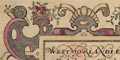
WESTMORLANDIAE et Cumberlandiae Comit~ nova Vera et Elaborata descriptio. Ano. Dn~i. 1576. Printed lower left:- CHRISTOPHORUS SAXTON DESCRIPSIT Printed under the scale line, lower left:- AUGUSTINUS RYTHER ANGLUS SCULPSIT ANo DN~I 1576 |
|
|
|
||
| coat of arms |
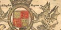
Printed upper right is the royal coat of arms of Elizabeth Regina quarterly 1 and 4 azure three fleur de lys or 2 and 3 gules three lions passant guardant or The supporters are a lion and a dragon, the latter for the welsh house of tudor. There is a crown above and below the motto:- DIEU ET MON DROYT Around the shield is the garter with its motto:- HONY SOIT QUI MAL Y PENSE Printed lower right is the coat of arms of Thomas Seckford with his motto:- Industria Naturam Ornat ie:- hard work improves on nature |
|
|
|
||
|
orientation
labelled borders up is N |
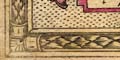
The map has a picture frame border in which there are panels labelling directions, in Latin:- 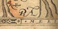
SEPTENTRIO ORIENS MERIDIES OCCIDENS ie North, East, South, West. The map is printed with North at the top of the sheet. |
|
|
|
||
|
scale line
dividers scale |
Printed lower left is a:-
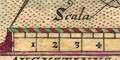
Scala Miliarium marked and labelled in miles with half mile subdivisions. The 10 miles = 65.4 mm gives a scale 1 to 246077 wrongly assuming a statute mile. Using an Old English Mile = 1.25 statute miles, the map scale is about:- 1 to 300000 5 miles to 1 inch Above the scale line is a pair of dividers with a pretty tudor rose at the pivot. The pernickety might notice that the lines of the dividers' inner edges do not go through its pivot, and the dividers would not close properly to a zero measurement. |
|
|
|
||
|
sea area
sea pecked sea monsters ships fishermen |
The sea area is pecked, and tinted with a blue wash, and
simply labelled:-
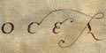
OCEANUS 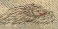
In the sea are a couple of monstrous fishes and a number of sailing ships. The ships include three, two and one masted square rigged sailing vessels. 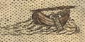
There are also two fishing boats with their single sail furled on its yard which is laid along the boat from stem to stern posts. Over the side of each boat is a fishing net being handled by two fishermen.
Detail notes by Ian Friel
|
|
|
|
||
|
coast line
coast shaded headlands harbours foreshore |
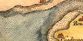
The coast line is shaded for emphasis, and tinted blue. The foreshore in the Solway Firth, and in what parts of the sands to the south which happen to be shown, are drawn in outline, the area pecked. The river channels are drawn boldly through these sands. On headland is labelled:- Sct bees head (There may be a colon for the abbreviation, but the dots might just be pecking.) And one harbour is labelled:- Derwenfoot haven at Workington. |
|
|
|
||
|
rivers
bridges |
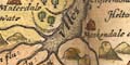
Rivers are drawn from the coast in a tapering double line with form lines, some rivers are labelled, eg:- Eden flu: Lune flu: Cauda flu: and some tributaries are drawn. Notice the tributaries of the River Lyne, Christopher Saxton's 'Leven', in the north of the county. The tributaries are the White Lyne and Black Lyne; Christopher Saxton calls them the Black Leven and White Leven respectively. One theory of black white pairs of this sort is that they simply imply the one and the other, so which way round is unimportant! 
Roads are not shown in the map, but a number of bridges are marked by a double line crossing and interrupting the stream. For example, over the Eamont and Lowther south of Penrith. A few bridges are labelled, eg:- New Bridge [Newby Bridge] Levens Bridge |
|
|
|
||
|
lakes
islands |
Lakes are drawn in outline, the area pecked, and shore
shaded. The larger lakes are labelled, some as if they were
just broad parts of a river, eg:-
Ulles flu: Loweswater Thurlemyer Brode Water Darwen flu: Wynandermere flu: An island in Derwent Water is labelled:- 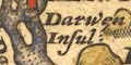
Darwen Insul: It is not always easy to identify other lakes, their connectivity and positions are confused (or my local knowledge is still weak?) See, for example, the four lakes in the Buttermere area. |
|
|
|
||
|
relief
hillocks |
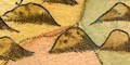
Relief is shown by hillocks, shaded on the east, tinted brown. Compared with the hillocks used in more southerly counties, the hillocks here are mountainous, giant size ugly lumps. A generous eye will see a concentration of mountains in the central lakes area and another along the Pennines, but the overall impression is not seriously informative. Some hills are labelled, eg:- Skiddow hill Fournes fells Helvillon hill Farleton knot hill Morton pike A group of hills on the Northumberland border are labelled:- Cristonbury cragg The gele crag The horse head The spy cragg |
|
|
|
||
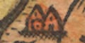
| beacons |
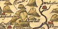
A hillock NNE of Penrith with a small ?tower on top is
perhaps Beacon Hill.
A hillock NE of Orton has a small ?tower on top, with ?flames. SW of Ireby is:- 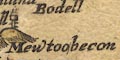
Mewtoobecon and on the hillock is a post with three rungs for climbing to the fire basket on top. |
|
|
|
||
|
woods
forests trees |
Tree symbols, tinted green, decorate some parks, but are
also used in groups to indicate woodland. Most woods are
unnamed, but notice:-
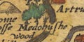
Medohushe wood Barren wood p~k [NW of Kirkoswald] Forest areas may not have tree symbols (forest does not imply trees) but might be labelled, eg:- 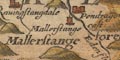
Mallerstange forest Inglewood forest Copeland forest Whinfeld forest |
|
|
|
||
| parks |
Parks are drawn in outline by a ring of fence palings,
the interior usually with some trees and perhaps a building.
Some parks are labelled, eg:-
Camswick p~k using the letter p with a bar on its descender, abbreviation for par. Or the park might be named by its house, eg:- 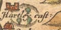
Hartley cast: Notice the large park west of Penrith, including two villages and a castle:- Lamonbye Johnbye Graystock cast: and a splendid stag in the woods. Ussay p~k [NW of Broughton in Furness] is labelled, but has no fence etc. |
|
|
|
||
|
county
swash lettering country boundary stones |
County boundaries are a dotted line, continued alongside a feature like a river where this happens. The inner side of each county boundary has a tint for the county: Westmorland pink, Cumberland green, Lancashire pink, Yorkshire yellow, Durham green, Northumberland pink. The colours are faded; in particular the pinks for Westmorland and Lancashire, which adjoin, look almost the same, but maybe not. The two county areas of the map are labelled:- WESTMORELANDIA CUMBERLANDIA The adjacent counties are labelled in fine swash lettering, eg:- LANCASTRIAE PARS EBORACENSIS PARS NORTHUMBRIAE PARS DUNELMENSIS EPISCOPATUS Notice that the map colouring is wrong on the eastern border. The Tees flu: is the boundary of Yorkshire and Durham, and has been missed, making the contact between Durham and the Cumbrian counties much longer than it should be. The northern boundary is a country border, to the north being:- 
SCOTIAE PARS A large hillock at the meet of Westmorland, Cumberland and Lancashire is labelled:- 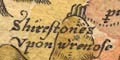
Shirestones upon wrenose and at the meet of Westmorland, Lancashire and Yorkshire, NE of Kirkby Lonsdale, is a hillock with a large stone on top labelled:- 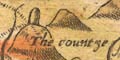
The countye stone Some settlements, hills and rivers are shown outside the two counties of the map. In particular the Pennines are continued down the eastern borders, and the fells continued into Lancashire north of the sands. |
|
|
|
||
| settlements |
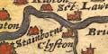
Settlements are marked by a dot and circle with buildings
and/or towers, tinted red which hides some detail, further
differentiated by style of labelling. Allocating settlement
classes to the symbols is not certain.
|
|
|
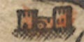
cities
towns |
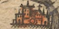
dot and circle, group of buildings, towers; labelled in italic block caps, eg:- 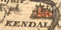
KENDAL CARLISLE BRAMPTON |
|
| villages |
dot and circle, building with tower, ie a church; labelled in italic lowercase text, eg:- 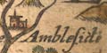
Ambleside Shapp Paterdale |
|
| hamlets |
dot and circle, building; labelled in italic lowercase text, eg:- 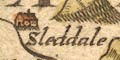
Sleddale [Longsleddale] Barnside [Burneside] Mylnthorpe |
|
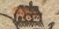
| houses |
dot and circle, tower; labelled in italic lowercase text, eg:- 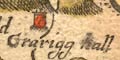
Grarigg hall Dalemain Sizerghe Arneside toure A great house at this period might be the centre of a cluster of dwellings, what looks like a hamlet today. |
|
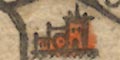
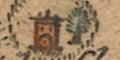
| castles |
dot and circle, pair of towers; labelled in italic lowercase text, eg:- 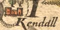
Kendall cast: Brougham cast: Pendragon cast: |
|
|
|
||
| miscellaneous | ||
|
|
||
| peat mosses |
On the Solway Firth an area north of Milnehill between
the Sark and Esk rivers is labelled:-
Sollome mosse presumably a peat moss. |
|
|
|
||
| mines |
On the hills north of Mosedale there are several black
diamond shapes, labelled:-
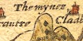
The mynes |
|
|
|
||
|
antiquities
roman sites roman wall |
A dashed line runs across the map from Boulnesse, past
Glason, Drumburgh castle, Burgh [by Sands], Kirkanders,
Grinsdale, Carlisle, up the Bruscarth river, then by
Waleton, Burdoswold, Wall towne, and eastwards. It is
labelled:-
THE WALL OF THE PICTES ie Hadrian's Wall. |
|
|
|
||
| stones |
A drawing of two or three stones standing on the
Westmorland Cumberland border in the pass between Grasmere
and Thirlmere is labelled:-
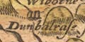
Dunbalrase stones ie Dunmail Raise. Boundary stones are noted under 'county'. |
|
|
|
||
| crosses |
Crosses are drawn on two hilltops. One on a hill east of
the spittle on stainmore. The other labelled:-
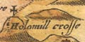
Holomill crosse NE of Pendragon Castle. |
|
Lakes Guides menu.