 Saxton 1579

|

|
|
|
item:- private collection (2) image:- © see bottom of page |
click to enlarge |
|

|
menu with map squares and placename index | |
|
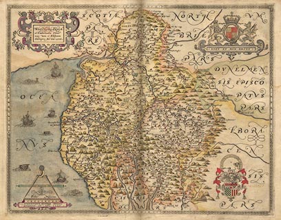
Map, hand coloured engraving, Westmorlandiae et
Cumberlandiae Comitatus ie Westmorland and Cumberland, scale
about 5 miles to 1 inch, by Christopher Saxton, London,
engraved by Augustinus Ryther, 1576, published 1579-1645.
Published in An Atlas of England and Wales by Christopher Saxton. London. 1579. The 1576 map carries the royal arms, of Elizabeth I, and the coat of arms of Thomas Seckford with his motto 'Industria Naturam Ornat' -- 'hard work improves on nature'; there are no roads. |
||
|
|
Saxton 1579 | |
| map feature:- | picture frame border & coat of arms (royal and family) & strapwork cartouche & labelled borders & scale line & dividers & sea monsters & galleons & sea stippled & coast shaded & rivers & relief & hillocks (some large) & parks & county & settlements | |
| inscription:- |
printed lower left
CHRISTOPHORUS SAXTON DESCRIPSIT |
|
| inscription:- |
printed strapwork title cartouche, upper left
WESTMORLANDIAE et Cumberlandiae Comit~ nova Vera et Elaborata descriptio. Ano. Dn~i. 1576. |
|
| inscription:- |
printed under scale line, lower left
AUGUSTINUS RYTHER ANGLUS SCULPSIT ANo DN~I 1576 |
|
| inscription:- |
printed
Industria Naturam Ornat coat of arms, Thomas Seckford |
|
| scale line:- | 10 miles = 65.4 mm | |
| scale:- | 1 to 246000 ? (1 to 246077 from scale line, wrongly assuming a statute mile) | |
|
|
notes | |