 Speed 1611

|

|
|
|
item:- Kendal Library : Map 1 image:- © see bottom of page |
click to enlarge |
|
|
Map, uncoloured engraving, The Countie Westmorland and
Kendale the Cheif Towne, scale about 2.5 miles to 1 inch, by
John Speed, 1610, published by Thomas Bassett, Fleet Street
and Richard Chiswell, St Paul's Churchyard, London, 1676.
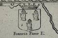
One of the county maps in the Theatre of the Empire of Great Britain, by John Speed. The map of Kendal is an inset map, a bird's eye view, at a larger scale, with a gazetteer of places. The reverse of the map is in English. The map is framed , all that may be read of the back is in English, and seems to include 'An [Alp ]l TABLE of [all the] Towns, Rivers, and /...' This edition of the map has an added coat of arms, upper left of centre, Francis Fane E. This and the other coats of arms are tricked to indicate colours. |
||

|
Speed 1611 | |
| map feature:- | picture frame border & swash lettering & strapwork cartouche & coat of arms & heraldic border & descriptive text & compass rose & labelled borders (English) & scale line (with dividers) & sea moire effect & coast shaded & rivers & lakes & relief & hillocks & woods & parks & county & settlements & inset map | |
| inscription:- |
printed title cartouche, upper right
THE / COUNTIE / WESTMORLAND / AND KENDALE THE / CHEIF TOWNE DE- / SCRIBED / With the Armes of such Nobles as have / bene Earles of / either of them. |
|
| inscription:- |
printed below the scale line, lower right
Performed John Speede, and are to be sold by Thomas / Bassett in Fleet street, and Ric : Chiswell in St. Pauls Churchyard. |
|
| inscription:- |
printed above the scale line
THE SCALE OF MILES |
|
| scale line:- | 9 miles = 91.5 mm (?) | |
| wxh, sheet:- | 57x44cm (?) | |
| wxh, map:- | 511x384mm (?) | |
| scale:- | 1 to 160000 ? (1 to 158296 from scale line wrongly assuming a statute mile) | |