 Garnett 1850s-60s J

|

|
|
|
item:- JandMN (235_1) image:- © see bottom of page |
click to enlarge |
|
|
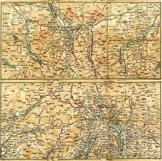
Map, colour lithograph, Lake District, scale about 2
miles to 1 inch, by J Bartholomew, Edinburgh, published by
John Garnett, Windermere, Westmorland, and by Simpkin,
Marshall and Co, London, 1865.
Taken from the pocket in the front cover of the guide book, Ascents and Passes in the Lake District of England, by Herman Prior. The map is two sided; it is torn from being folded and unfolded. An owner has marked itineraries in red ink. |
||

|
Garnett 1850s-60s J | |
| map feature:- | folded (3x) & up is N & scale line & rivers & lakes & relief & hill hachuring & woods & forests & parks & settlements & roads & railways | |
| inscription:- |
printed bottom left, right
Windermere; J. Garnett. / J. Bartholomew, Edinr. |
|
| inscription:- |
printed with scale line
Miles |
|
| scale line:- | 4 miles = 51.0 mm | |
| wxh, folded:- | 11x8cm | |
| wxh, sheet:- | 32.5x16cm | |
| wxh, map:- | 318x153mm | |
| scale:- | 1 to 130000 ? (1 to 126223 to from scale line) | |