 Collins 1849-52

|

|
|
|
item:- JandMN (234) image:- © see bottom of page |
click to enlarge |
|
|
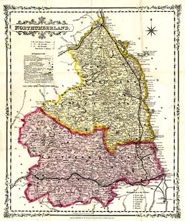
Railway map, coloured lithograph, Northumberland with its
Railways, scale about 4.5 miles to 1 inch, published by H G
Collins, 22 Paternoster Row, London, about 1849-52.
|
||

|
Collins 1849-52 | |
| map feature:- | card cover & folded (4x3) & wreath cartouche (!?) & table of symbols & compass rose & up is N & scale line & lat and long scales & rivers & relief & hill hachuring & parks & county & wards & table of wards & settlements & roads & turnpike roads & railways & canals & electoral data | |
| inscription:- |
printed cover
NORTHUMBERLAND / WITH ITS RAILWAYS. / SIXPENCE. / PUBLISHED BY / H. G. COLLINS, PATERNOSTER ROW, / LONDON, / AND SOLD AT / ALL THE RAILWAY STATIONS. |
|
| inscription:- |
printed title cartouche, upper left
NORTHUMBERLAND. |
|
| scale line:- | 10+1 miles = 63.9 mm | |
| wxh, folded:- | 10.5x16cm | |
| wxh, sheet:- | 37.5x45cm | |
| wxh, map:- | 341x418mm | |
| scale:- | 1 to 280000 ? (1 to 277039 from scale line) | |