 Stanford 1907

|

|
|
|
item:- JandMN (193_2) image:- © see bottom of page |
click to enlarge |
|
|
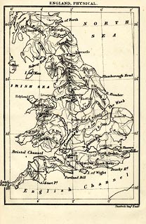
Map, uncoloured lithograph, England, Physical, including
Wales, scale about 77 miles to 1 inch, by Stanford's
Geographical Establishment, London, edn 1930.
Tipped in at the end of The Counties of England, Ambleside Geography Books series, by Charlotte M Mason. |
||

|
Stanford 1907 | |
| map feature:- | up is N & lat and long scales (trapezoidal projection) & lat and long grid (2 degree intervals) & sea plain & coast line & rivers & relief & hill hachuring & settlements | |
| inscription:- |
printed top
ENGLAND, PHYSICAL |
|
| inscription:- |
printed bottom right
Stanford's Geogl. Estabt. |
|
| wxh, sheet:- | 12x18.5cm | |
| wxh, map:- | 95x140mm | |