 Pinnock 1833-34

|

|
|
|
item:- Armitt Library : ALMC2008.14.126 image:- © see bottom of page |
click to enlarge |
|
|
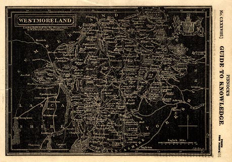
Map, reversed out white on black, Westmoreland ie
Westmorland, scale about 6 miles to 1 inch, engraved by J
Archer, published by William Edwards, 12 Ave Maria Lane,
London, 1834.
Included in Pinnock's Guide to Knowledge, no.138, 1834. |
||

|
Pinnock 1833-34 | |
| map feature:- | plain cartouche & coat of arms & north point & up is N & scale line & lat and long scales & sea shaded & coast line & rivers & lakes & relief & hill hachuring & county & settlements & roads | |
| inscription:- |
upper left
WESTMORELAND |
|
| inscription:- |
printed
head of page, right of map |
|
| inscription:- |
below title cartouche
London. Published for the Proprietors, / by W. Edwards, 12 Ave Maria Lane. |
|
| inscription:- |
printed lower right
J. Archer sc. |
|
| inscription:- |
printed above scale line
English Miles |
|
| scale line:- | 10 miles = 42.8 mm | |
| wxh, sheet:- | 27x19.5cm | |
| wxh, map:- | 231x166mm | |
| scale:- | 1 to 380000 ? (1 to 376015 from scale line assuming a statute mile) | |