 Hondius 1607

|

|
|
|
item:- Armitt Library : ALMC2008.14.13 image:- © see bottom of page |
click to enlarge |
|
|
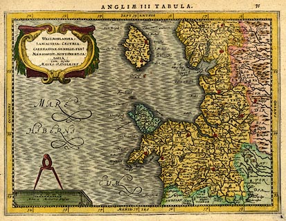
Map, hand coloured engraving, Westmorlandia, Lancastria,
Cestria ... ie Westmorland, Lancashire, Cheshire ..., which
is England plate 3, scale about 21.5 miles to 1 inch,
probably engraved by Peter Keer, published by John
Cloppenburg, Amsterdam, Netherlands, 1630, edition 1632.
The text on the reverse, p.76, is in Latin, the map on page 75, which identies it as coming from Gerardi Mercatoris Atlas, 1632. The map is a new engraving, probably by Pieter van den Keere, from the small map by Jodocus Hondius 1607, derived from Mercator's larger map 1595, for a new edition of Gerard Mercator's Atlas Minor. |
||

|
Hondius 1607 | |
| map feature:- | scroll cartouche & swash lettering & scale line (and dividers) & labelled borders (Latin) & up is N & lat and long scales (rectangular projection? longitude E from some in the Atlantic) & sea moire effect & coast shaded & rivers & lakes & relief & hillocks & county & settlements | |
| inscription:- |
printed title cartouche, upper left
WESTMORLANDIA / LANCASTRIA, CESTRIA / CAERNARVAN, DENBIGH, FLINt, / MERIONIDH, MONTGoMERY, SA : / LOPIA / Cum insulis / MANIA et ANGLESEY spelling mistakes are corrected with small letters t and o inserted |
|
| inscription:- |
printed top right
75 page/plate number |
|
| inscription:- |
printed top
ANGLIAE III TABULA. |
|
| inscription:- |
printed below scale line, lower left
Miliaria Mediocria Angliae |
|
| scale line:- | 20 miles = 23.7 mm | |
| wxh, sheet:- | 28x22cm | |
| wxh, plate:- | 255x187mm | |
| wxh, map:- | 253x184mm | |
| scale:- | 1 to 1400000 ? (1 to 1358096 from scale line wrongly assuming a statute mile) | |