 Crosthwaite 1783-94

|

|
|
|
item:- Armitt Library : 1959.191.7 image:- © see bottom of page |
click to enlarge |
|

|
menu with map squares and placename index | |
|
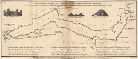
Map, uncoloured engraving, Accurate Map of the Beautiful
Lake of Ullswater, scale about 3 inches to 1 mile, by Peter
Crosthwaite, Keswick, Cumberland, 1783, version published
1800.
|
||
|
|
Crosthwaite 1783-94 | |
| map feature:- | vignettes & compass rose & up is SE & scale line & lat and long data & rivers & lakes & depth soundings & settlements & roads | |
| inscription:- |
printed upper centre
An Accurate MAP of the beautiful Lake of ULLES-WATER, situate in CUMBERLAND and WESTMORLAND. / P. CROSTHWAITE, ... Surveyed Ulls-water in April 1783, & constructed this MAP accordingly. |
|
| inscription:- |
printed bottom centre and right
London Published as the Act directs, June 16th. 1783. Republished with additions as the Act directs, 1. Decr. 1788. Republished again with other additions May the 1st. 1794. - and Sold by Peter Crosthwaite, at his Museum Keswick. Republished with further additions June 20th. 1800. / Engrav'd by H. Ashby. |
|
| scale line:- | 1 mile = 71.9 mm | |
| wxh, sheet (badly trimmed):- | 51x22cm | |
| wxh, map:- | 509x212mm | |
| scale:- | 1 to 22000 ? (1 to 22383 from scale line assuming a statute mile) | |
|
|
notes | |