 Otley 1818

|

|
|
|
item:- JandMN (48_1) image:- © see bottom of page |
click to enlarge |
|

|
menu with map squares and placename index | |
|
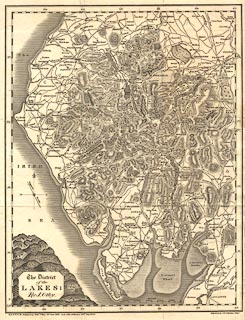
Map, uncoloured engraving, The District of the Lakes,
Cumberland, Westmorland, and Lancashire, scale about 4 miles
to 1 inch, by Jonathan Otley, 1818, engraved by J and G
Menzies, Edinburgh, Scotland, published by Jonathan Otley,
Keswick, Cumberland, et al, 1833.
Included in A Concise description of the English Lakes, by Jonathan Otley, 5th edition, 1834. The map dates from 1817-18. |
||
|
|
Otley 1818 | |
| map feature:- | plain cartouche & north point & magnetic deviation & scale line & lat and long scales & sea plain & coast shaded & rivers & lakes & relief & hill hachuring & table of heights & settlements & roads & canals | |
| inscription:- |
printed title cartouche, lower left
The District / of the / LAKES; / By J. Otley |
|
| inscription:- |
printed bottom
KESWICK Published by Jona. Otley 21st June 1827. And, with additions, 20th. July 1833. |
|
| scale line:- | 10 miles = 63.4 mm | |
| scale:- | 1 to 250000 ? (1 to 253840 from scale line) | |
| wxh, sheet:- | 28x37.5cm | |
| wxh, map:- | 262x338mm | |
|
|
notes | |