 Otley 1818

|

|
|

|
back to object record | |
| MAP FEATURES | ||
|
|
||
|
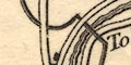
title cartouche
plain cartouche map maker publisher engraver |
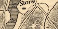
Printed in a plain cartouche, lower left:-
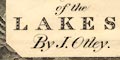
The District of the LAKES; By J. Otley The cartouche is embedded in a pile of hills, with heights, described below. Printed at the bottom:- KESWICK Published by Jona. Otley 21st June 1827. And, with additions, 20th. July 1833. / Engraved by J. & G. Menzies, Edinr. |
|
|
|
||
|
orientation
north point magnetic deviation up is N |
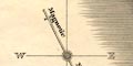
Printed upper left is a north point; N-S line, North marked by a spear point/fleur de lys, E-W line labelled W E. A line is engraved across the north point, 28d West ie anticlockwise from North, labelled:- Magnetic Needle The map is printed with North at the top of the sheet. |
|
|
|
||
|
scale line
scale |
Printed lower centre is a scale of:-
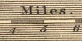
Miles. chequered and labelled in miles. The 10 miles = 63.4 mm gives a scale 1 to 253840. The map scale is about:- 1 to 250000 4 miles to 1 inch |
|
|
|
||
|
lat and long
lat and long scales |
Printed in the map borders are scales of latitude and longitude for a trapezoidal projection? just not rectangular; chequered in minutes, labelled at 10 minute intervals. The map includes from 2d 40m to 3d 38m West, from 54d 2m to 54d 47m North; the central Lake District, Lancashire to just north of Sebergham, from the coast as far east as Shap. |
|
|
|
||
|
sea area
sea plain |
The sea area is plain, labelled:-
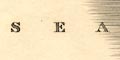
The IRISH SEA |
|
|
|
||
|
coast line
coast shaded foreshore sands |
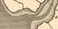
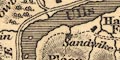
The coast line is heavily shaded for emphasis. Foreshore shallows are pecked, in particular the areas of sands are shown, and labelled:- Cartmel Wharf Lancaster Sands Rocks might be shown by crosses, as off the shore of the Isle of Walney. One island is labelled:- ISLE of WALNEY but a couple of others can be recognised, eg:- Piel Island Chapel Island |
|
|
|
||
|
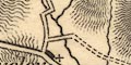
rivers
bridges ferries waterfalls |
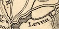
Rivers are drawn by wiggly line tapering upstream. A wider river might be drawn by double line, with form lines, for example the Lune near Lancaster. Some rivers are labelled, eg:- Leven R. Duddon River River Kent Cockley Beck Where the flo of a river is not clear there might be an arrow, as on the Eden at the north of the map area. Bridges are implied where a road crosses and interrupts a stream. A few are labelled, though it is not always clear whether a bridge or settlement is labelled, eg:- 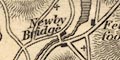
Newby Bridge Pooley Bridge Santon Bridge The last is labelled alongside a village labelled Pooley. There are bridges shown by a double line across a stream, without any nearby road, for example over the Kent north of Burneside. By Windermere there is a label:- Ferry 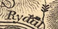
A waterfall might be indicated, for example see the three down arrows across the stream line above Rydal. Less clear are the arrows under the label:- Scale Force by Crummock Water. |
|
|
|
||
| lakes |
Lakes are drawn in outline, shaded. Some larger lakes are
labelled:-
Ulls Water DERWENT BASSENTHWAITE Crummock Thirlmere Hawes Water Burnmoor Tarn Elter Water Blea Tarn WINDER MERE Esthwaite Water Blelham Devoke Water Over Water I might not have found all; and many others can be recognised, including a number of small tarns, for example:- Loweswater Buttermere Ennerdale Water Wast Water Grasmere Rydal Water Brothers Water Hayeswater Blea Water Small Water Kentmere Tarn Skeggles Water Coniston Water Urswick Tarn etc etc. Islands are drawn in several lakes and a number might be recognised. None are labelled. |
|
|
|
||
|
relief
hill hachuring |
Relief is indicated by attractive hill hachuring which
clearly shows where is hilly, though not in any quantitative
way. Many hills are labelled, eg:-
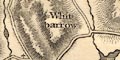
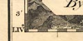
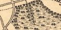
White barrow SKIDDAW Ill Bell Place Fell Screes Stickle Pikes Valleys might be labelled, eg:- ESKDALE LANGDALE Although not called a pass, there are labels:- Kirkstone Wrynose Printed lower right, overlaid by the title cartouche, is a diagram of the heights of hills. The picture is a pile of summits at their relative heights, each labelled:- 
Pikes / 3160 Scawfell / 3100 Hevellyn / 3070 Skiddaw / 3022 Gable / 2925 Bowfell / 2911 Pillar / 2893 Grasmoor / 2756 Old Man / 2577 Grisedale Pike / 2580 Stickle or Langdale Pikes / 2400 Carrock / 2110 Causey / 2030 Black Combe / 1919 Lord's Seat / 1728 Wansfell / 1590 Cat Bell / 1448 Latrigg / 1160 Scilly Bank / 500 St Bees Heads 222 Feet above the Sea |
|
|
|
||
|
woods
trees |
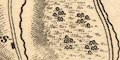
A few areas of woodland are indicated by groups of tree symbols. Although not delimited by a paling fence these are in parks at Greystoke, Gowbarrow, and Lowther. In the wooded area a tussock symbol is used to show the whole area, and this symbol alone shows the ?forest area of the fell between Threlkeld and Matterdale. At laest one forest area is labelled:- Naddle Forest |
|
|
|
||
| parks |
Parks are generally ignored but notice that the groups of tree symbols show the extent of Greystoke, which has a dotted outline and avenues of trees on its boundaries, and of Lowther parks and there are trees and label:- Gowbarrow Parks by Ullswater. |
|
|
|
||
| county |
The county boundaries are a dotted line, but this does not show where it lies with another feature. The county areas are labelled:- CUMBERLAND WESTMORLAND LANCASHIRE Not all of each county is included. |
|
|
|
||
| settlements |
Settlements are marked by blocks or small groups of
blocks, perhaps with a cross (+) for a church,
differentiated by style of lettering.
|
|
| towns |
group of blocks; labelled in upright block caps, eg:-
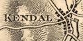
KENDAL RAVENGLASS MARYPORT |
|
| villages |
group of blocks and/or a cross; labelled in italic block
caps, eg:-
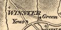
WINSTER BUTTERMERE DACRE |
|
| hamlets |
block and/or a cross; labelled in italic lowercase text,
eg:-
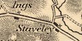
Ings Staveley Ullock |
|
|
But: various sizes of italic and upright lowercase text
are used for other features on the map, and block caps for
dales.
The distinction of town, village, hamlet is not very helpful, or reliable! |
||
|
|
||
| roads |
Roads and tracks are drawn by a double line, solid or dotted. Broader roads have the lines light bold, described as shaded by some, which suggests turnpiking. A network of routes covers the area. Destinations at road ends are given, eg:- The sands roads are shown:- To Appleby 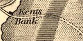
from Hest Bank, across Lancaster Sands and the Kent Estuary, to Kents Bank. from west Holker, across Ulverston Sands and the Leven Estuary, to the foot of Ulverston Canal. from the coast near Ireleth, across the Duddon Estuary, to the coast near Millom. ?across the tip of the Esk Estuary, south of Ravenglass. |
|
|
|
||
| canals |
Canals are drawn by a double line; light very bold. The
two canals are labelled:-
|
|
| Lancaster Canal | ||
from the south, through Lancaster to Kendal, labelled:- The Lancaster Canal The Lune Aqueduct is clearly recognisable; and notice the canal basin in Kendal. |
||
| Ulverston Canal | ||
|
from a building west of Ulverston to the coast,
labelled:-
Canal |
||
|
|
||
| miscellaneous | ||
|
|
||
| lighthouses |
On St Bees Head is a tower labelled:-
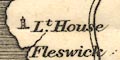
Lt. House |
|
|
|
||
| spas |
Just off the edge of the map, south of Shap, is a circle
labelled:-
spaw which is Shap Wells. |
|
|
|
||
|
water mills
mills |
A water mill is drawn by a starred wheel near Kellet,
labelled:-
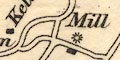
Mill though no river is shown. |
|
|
|
||
| inns |
An inn might be shown, for example at the north end and
to the west of Bassenthwaite Lake are:-
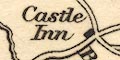
Castle Inn Wheatsheaf |
|
|
William Green thanks Jonathan Otley for his help, in the
preface to his Tourist's New Guide, published 1819:-
|
||
|
Mr. Otley ... has studied, with much industry, the natural
history of the district. Watch repairing, is a part of Mr.
Otley's employment, and his general turn for mechanics, has
qualified him to construct various portable mathematical
instruments. To a pocket compass, he has adapted a graduated
circle, which being placed when wanted, on the top of his
walking stick, he observes the relative direction of
surrounding hills, and by a barometer, he calculates their
heights. He constructed the map accompanying this work, and
his travels, and observations, have enabled him to correct
some of the errors of former maps. The altitude of mountains
are chiefly taken from the trigonometrical survey, published
by order of the board of ordnance, but from which, though
little, he has in a few instances presumed to vary; these
are added to the heights of other hills not before
published.
|
||
Lakes Guides menu.