 Jefferys 1770 NY30SE

|

|
|
|
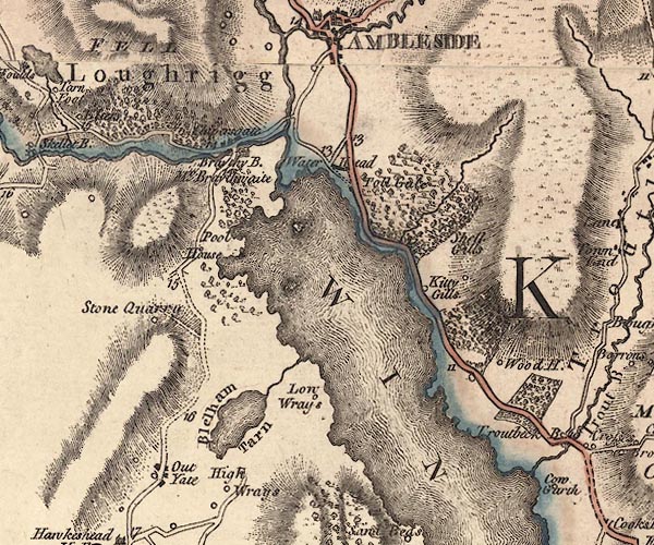
gazetteer links places may or may not be labelled on the map |
||

|
-- Blelham Beck |
|
|
|
-- Blelham Tarn -- "Blelham Tarn" |
|
|
|
-- Brathay Bridge -- "Brathay B." |
|
|
|
-- Brathay, River |
|
|
|
-- Clappersgate -- "Clapersgate" |
|
|
|
-- High Skelghyll -- "Shell Gills" |
|
|
|
-- High Wray -- "High Wrays" |
|
|
|
-- Hol Beck |
|
|
|
-- Kittygills -- "Kitty Gills" |
|
|
|
-- Loughrigg -- "Loughrigg" |
|
|
|
-- Low Skelghyll -- "Shell Gills" |
|
|
|
-- Low Wray -- "Low Wrays" |
|
|
|
-- Newclose Wood |
|
|
|
-- Old Brathay -- "Mr. Braythwaite" |
|
|
|
-- Outgate -- "Out Yate" |
|
|
|
-- Pull Woods |
|
|
|
-- Pull Wyke House -- "Pool House" |
|
|
|
-- quarry, Hawkshead -- "Stone Quarry" |
|
|
|
-- Ambleside to Coniston |
|
|
|
-- Ambleside to Hawkshead |
|
|
|
-- Skelwith Bridge to Ravenglass -- "From White
Haven" |
|
|
|
-- Windermere to Ambleside |
|
|
|
-- Rothay, River |
|
|
|
-- Skelghyll Wood |
|
|
|
-- toll gate, Waterhead -- "Toll Gate" |
|
|
|
-- Wansfell |
|
|
|
-- Waterhead -- "Water Head" |
|
|
|
-- Windermere lake -- "WINANDERMERE" |
|
|
|
-- Wood Farm -- "Wood H." |
|
|
civil parishes The area roughly includes parts of parishes:- Lakes Skelwith Hawkshead Claife Windermere |
||
|
|
||
|
|
Lakes Guides menu. | |