Old Cumbria Gazetteer
 |
 |
|
|||||||||||||||||||||||||||
| included in:- |
 road, Kendal to Cockermouth road, Kendal to Cockermouth |
||||||||||||||||||||||||||||
| road, Windermere to Ambleside | |||||||||||||||||||||||||||||
| Windermere to Ambleside | |||||||||||||||||||||||||||||
| Ambleside to Windermere | |||||||||||||||||||||||||||||
| A591 | |||||||||||||||||||||||||||||
| civil parish:- | Windermere (formerly Westmorland) | ||||||||||||||||||||||||||||
| civil parish:- | Lakes (formerly Westmorland) | ||||||||||||||||||||||||||||
| county:- | Cumbria | ||||||||||||||||||||||||||||
| locality type:- | road route | ||||||||||||||||||||||||||||
| 10Km square:- | SD49 | ||||||||||||||||||||||||||||
| 10Km square:- | NY40 | ||||||||||||||||||||||||||||
| 10Km square:- | NY30 | ||||||||||||||||||||||||||||
|
|
|||||||||||||||||||||||||||||
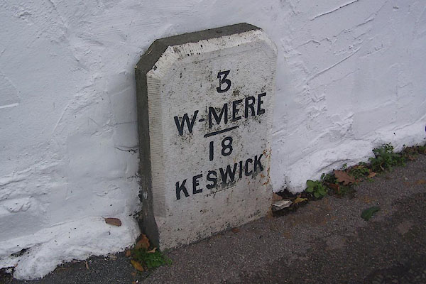
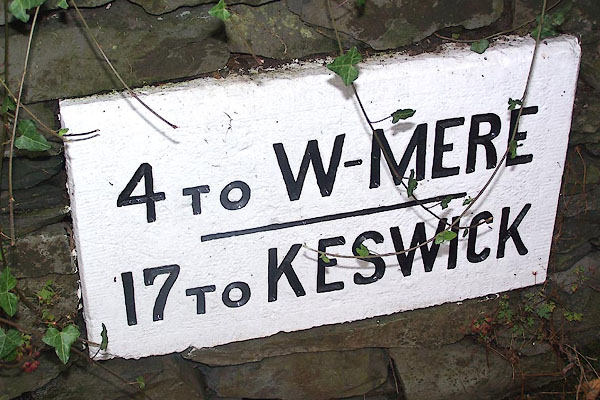
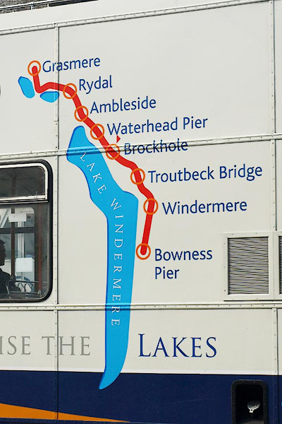 BPB72.jpg Map on the side of a bus, at Ambleside bus stance. (taken 21.4.2008) 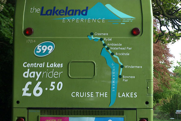 BUM76.jpg Map on the back of a bus, near Lowwood. (taken 3.5.2011) |
|||||||||||||||||||||||||||||
|
|
|||||||||||||||||||||||||||||
| evidence:- | old map:- Ogilby 1675 |
||||||||||||||||||||||||||||
| source data:- | Road strip map, hand coloured engraving, the Road from Kendal to
Cockermouth, and the Road from Egremond to Carlisle, scale about
1 inch to 1 mile, by John Ogilby, London, 1675.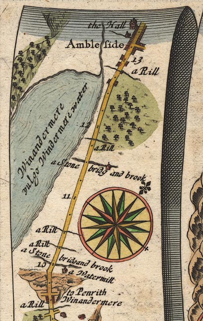 OG96WtoA.jpg item:- JandMN : 22 Image © see bottom of page |
||||||||||||||||||||||||||||
|
|
|||||||||||||||||||||||||||||
| evidence:- | descriptive text:- Fiennes 1698 |
||||||||||||||||||||||||||||
| source data:- | Travel book, manuscript record of Journeys through England
including parts of the Lake District, by Celia Fiennes, 1698. "Thence [Bowness] I rode almost all the waye in sight of this great water [Windermere]; some tymes I lost it by reason of the great hills interposeing and so a continu'd up hill and down hill and that pretty steep even when I was in that they called bottoms, which are very rich good grounds," |
||||||||||||||||||||||||||||
|
|
|||||||||||||||||||||||||||||
| evidence:- | old map:- Bowen 1720 (plate 260) |
||||||||||||||||||||||||||||
| source data:- | Road strip map, uncoloured engraving, pl.260, The Road from
Kendal to Cockermouth, scale about 2 miles to 1 inch, with
sections in Westmorland and Cumberland, published by Emanuel
Bowen, St Katherines, London, 1720.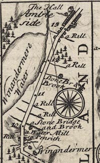 B260WtoA.jpg The Road from Kendal to Cockermouth - from Kendal on past Keswick, Cumberland. Places labelled are:- ... 10 ... Winandermere Water on the left ... 13 / Ambleside, The Hall / 14 ... item:- private collection : 1.260 Image © see bottom of page |
||||||||||||||||||||||||||||
|
|
|||||||||||||||||||||||||||||
| evidence:- | old map:- Bowen 1720 (plate 259) |
||||||||||||||||||||||||||||
| source data:- | Road book, Britannia Depicta Or Ogilby Improv'd, including road
strip maps with sections in Westmorland and Cumberland, scale
about 2 miles to 1 inch, derived from maps by Ogilby, 1675, also
a county map of Westmorland, scale about 8 miles to 1 inch, and
of Cumberland, scale about 16.5 miles to 1 inch, each with text,
by John Owen, published by Emanuel Bowen, London, 1720;
published 1720-64. Plate 259 has the title cartouche for:- "The Roads from KENDAL to COCKERMOUTH, &c. Containing 32 Comp. and 43'7 measd. Miles &c." and a table of distances, computed and measured miles in miles'furlongs, which includes, from Kendal:- "..." "Ambleside 10 / 13'3" "..." |
||||||||||||||||||||||||||||
|
|
|||||||||||||||||||||||||||||
| evidence:- | old map:- Badeslade 1742 placename:- |
||||||||||||||||||||||||||||
| source data:- | Map, uncoloured engraving, A Map of Westmorland North from
London, scale about 10 miles to 1 inch, with descriptive text,
by Thomas Badeslade, London, engraved and published by William
Henry Toms, Union Court, Holborn, London, 1742. click to enlarge click to enlargeBD12.jpg "" double line item:- Dove Cottage : 2007.38.62 Image © see bottom of page |
||||||||||||||||||||||||||||
|
|
|||||||||||||||||||||||||||||
| evidence:- | old map:- Bowen and Kitchin 1760 |
||||||||||||||||||||||||||||
| source data:- | Map, hand coloured engraving, A New Map of the Counties of
Cumberland and Westmoreland Divided into their Respective Wards,
scale about 4 miles to 1 inch, by Emanuel Bowen and Thomas
Kitchin et al, published by T Bowles, Robert Sayer, and John
Bowles, London, 1760.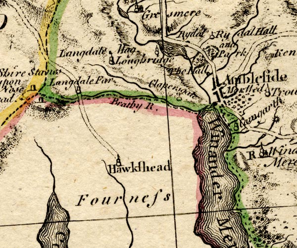 BO18SD29.jpg double line, solid, road distance 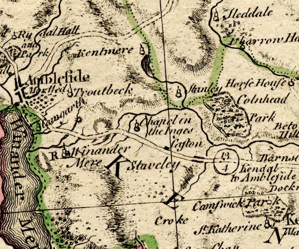 BO18SD39.jpg double line, solid, road distance item:- Armitt Library : 2008.14.10 Image © see bottom of page |
||||||||||||||||||||||||||||
|
|
|||||||||||||||||||||||||||||
| evidence:- | old map:- Kitchin 1767 (plate 84) |
||||||||||||||||||||||||||||
| source data:- | Road strip map, uncoloured engraving, The Road from Kendal to
Cockermouth, and The Road from Egremont to Carlisle, in
Kitchin's Post Chaise Companion, by Thomas Kitchin, published by
Robert Sayer, 53 Fleet Street, John Bowles, Cornhill, and
Carington Bowles, St Paul's Church Yard, London, 1767.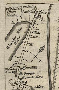 K084WtoA.jpg item:- Hampshire Museums : FA1999.138.84 Image © see bottom of page |
||||||||||||||||||||||||||||
|
|
|||||||||||||||||||||||||||||
| evidence:- | old map:- Jefferys 1770 (Wmd) |
||||||||||||||||||||||||||||
| source data:- | Map, 4 sheets, The County of Westmoreland, scale 1 inch to 1
mile, surveyed 1768, and engraved and published by Thomas
Jefferys, London, 1770. J5NY30SE.jpg  J5SD49NW.jpg double line; road, bold, main road, with mile numbers item:- National Library of Scotland : EME.s.47 Images © National Library of Scotland |
||||||||||||||||||||||||||||
|
|
|||||||||||||||||||||||||||||
| evidence:- | descriptive text:- West 1778 (11th edn 1821) |
||||||||||||||||||||||||||||
| source data:- | Guide book, A Guide to the Lakes, by Thomas West, published by
William Pennington, Kendal, Cumbria once Westmorland, and in
London, 1778 to 1821. goto source Page 73:- "From Bowness to Ambleside is six miles, along the side of the lake [2]. On the top of" "[2] The Low-Wood Inn, ..." goto sourcePage 74:- "an eminence, a little behind Rayrig, there is a fine view of the northern extremity of the lake. As you proceed along the banks, every step has importance, and the prospect becomes more and more august, exhibiting much variety of Appenine grandeur. Langdale-pikes, that guard the pass into Borrowdale on this side of the Yoak, and spiral Hill-bell; the overhanging crags of lofty Rainsbarrow; the broken ridge of Redscrees, Fairfield, and Scrubby-crag (on whose precipitous front the eagle builds his nest, secure from the envious shepherds of the vale) with a chaos of other nameless mountains, are all in sight." goto sourceAddendum; Mr Gray's Journal, 1769 Page 212:- "..." "[from Ambleside to Windermere]... The road in general fine turnpike, but some parts (about three miles in all) not made, yet without danger." "For this determination I was unexpectedly well rewarded; for the afternoon was fine, and the road for the space of full five miles, ran along the side of Windermere, with delicious views across it, and almost from one end to the other. ..." goto sourcePage 213:- "... The way rises continually, till a place called Orrest-head where it turns south-east, losing sight of the water. ..." |
||||||||||||||||||||||||||||
|
|
|||||||||||||||||||||||||||||
| evidence:- | old map:- Crosthwaite 1783-94 (Win/Ble) |
||||||||||||||||||||||||||||
| source data:- | Map, uncoloured engraving, An Accurate Map of the Grand Lake of
Windermere, scale about 2 inches to 1 mile, by Peter
Crosthwaite, Keswick, Cumberland, 1783, version published 1819. CT9NY30S.jpg double line 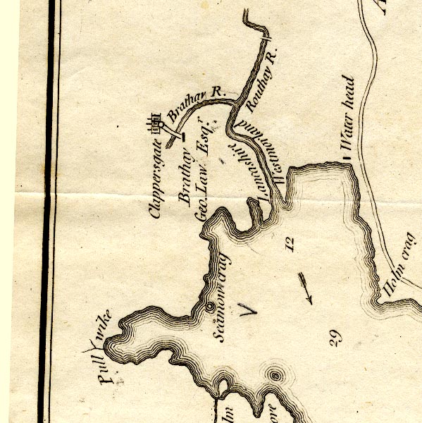 CT9NY30R.jpg double line 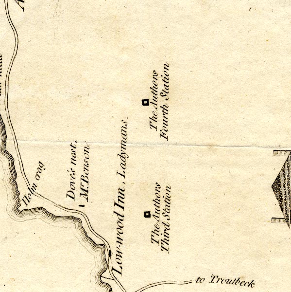 CT9NY30W.jpg double line 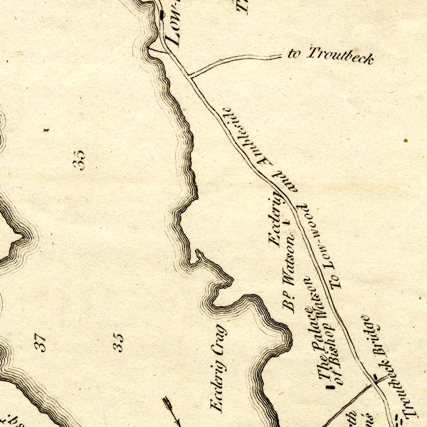 CT9NY30V.jpg "To Low-wood and Ambleside" double line, and turning "to Troutbeck" 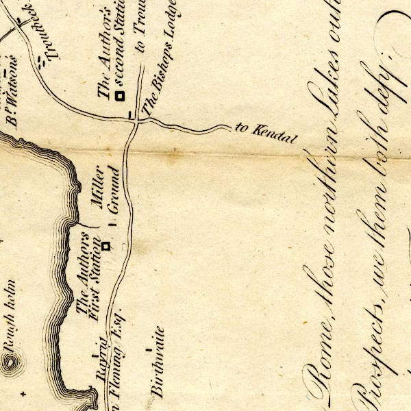 CT9SD49E.jpg double line, turnings labelled "to Troutbeck" "to Kendal" 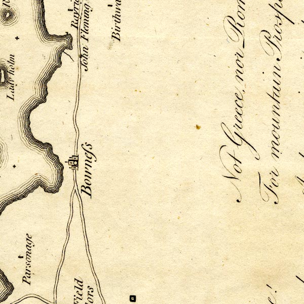 CT9SD49D.jpg double line, turning lakeside south of Bowness 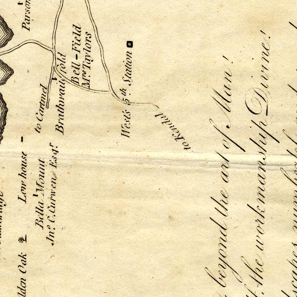 CT9SD49C.jpg "to Kendal" double line, and other roads to Ferry Nab, and to the lakeside road, which is labelled "to Cartmel" item:- Armitt Library : 2008.14.102 Image © see bottom of page |
||||||||||||||||||||||||||||
|
|
|||||||||||||||||||||||||||||
| evidence:- | old print:- Middiman 1784-92 |
||||||||||||||||||||||||||||
| source data:- | Print, uncoloured engraving, View of Winandermere Lake, Westmorland, drawn by F Wheatly,
engraved and published by Samuel Middiman, 3 Grafton Street, Tottenham Court Road,
London, 1786.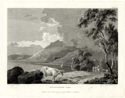 click to enlarge click to enlargeMM0601.jpg "Drawn by F. Wheatly. / Engrav'd by S. Middiman. / WINANDERMERE LAKE. / Publish'd as the Act directs, May 25. 1786, by S. Middiman, London." "Plate 2nd." item:- Armitt Library : A6863.1 Image © see bottom of page |
||||||||||||||||||||||||||||
|
|
|||||||||||||||||||||||||||||
| evidence:- | old print:- Middiman 1784-92 |
||||||||||||||||||||||||||||
| source data:- | Print, uncoloured engraving, View at Ambleside, Westmorland, drawn by C Powel, engraved
and published by Samuel Middiman, 3 Grafton Street, Tottenham Court Road, London,
1786.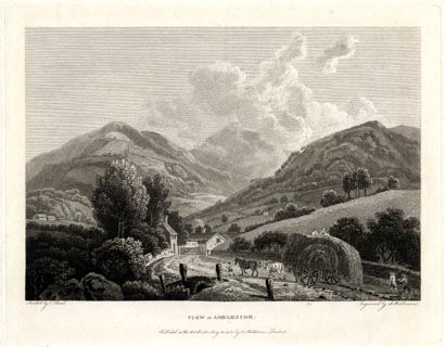 click to enlarge click to enlargeMM0602.jpg "Drawn by C. Powel. / Engrav'd by S. Middiman. / VIEW at AMBLESIDE. / Publish'd as the Act directs, May 25. 1786, by S. Middiman, London." Accompanying text:- "PLATE XXII." "VIEW at AMBLESIDE," "WESTMORELAND." "THE annexed View is taken on the Road from Winandermere, within a few Yards of Ambleside Turnpike, and not far distant from that represented on the preceding Plate." "From Ambleside to Keswick is about Sixteen Miles of excellent road; the Hills through which it leads are not difficult of Ascent, being mostly fine Sheep Walks, and well turfed. A Variety of Mountain Prospects present themselves in this Tour; and the Waterfalls that appear successively, either trickling down the gray Rocks, or pouring from the Mountains in foaming Torrents, are not to be equalled in so small a Tract of Country." item:- Armitt Library : A6863.2 Image © see bottom of page |
||||||||||||||||||||||||||||
|
|
|||||||||||||||||||||||||||||
| evidence:- | old print:- Middiman 1784-92 |
||||||||||||||||||||||||||||
| source data:- | Print, uncoloured engraving, View at Ambleside, Westmorland, painted by C Powel, engraved
and published by Samuel Middiman, London, 1786.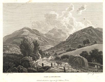 click to enlarge click to enlargeBNF32.jpg There is accompanying text in English and French:- "PLATE XXII. / VIEW at AMBLESIDE, WESTMORELAND. / THE annexed View is taken on the road from Winandermere, within a few Yards of Ambleside Turnpike, and not far distant from that represented in the preceding Plate. / From Ambleside to Keswick, is about Sixteen Miles of excellent Road; the Hills through which it leads are not difficult of Ascent, being mostly fine Sheep Walks, and well turfed. A variety of Mountain Prospects present themselves in this Tour; and the Waterfalls that appear successively, either trickling down the gray Rocks, or pouring from the Mountains in foaming Torrents, are not to be equalled in so small a Tract of Country." item:- Dove Cottage : 2007.38.125 Image © see bottom of page |
||||||||||||||||||||||||||||
|
|
|||||||||||||||||||||||||||||
| evidence:- | old text:- Gilpin 1786 |
||||||||||||||||||||||||||||
| source data:- | Book, Observations, Relative Chiefly to Picturesque Beauty, Made
in the Year 1772, on Several Parts of England, Particularly the
Mountains, and Lakes of Cumberland Westmoreland, by Rev William
Gilpin, 1772-74; published 1786-1808. goto source vol.1 p.134 "..." "... From Ambleside we set out for Bowness, to take a view of the lake. Part of the road we had traversed, the day before, from Kendal; and were a second time amused by the woody landscape it afforded: and it's sudden, interrupted openings to the lake, before the whole burst of that magnificent scene was presented. ..." |
||||||||||||||||||||||||||||
|
|
|||||||||||||||||||||||||||||
| evidence:- | old map:- Clarke 1787 map (Windermere N) |
||||||||||||||||||||||||||||
| source data:- | Map, A Map of the Northern Part of the Lake Winandermere and its
Environs, scale about 6.5 ins to 1 mile, by James Clarke,
engraved by Samuel John Neele, 352 Strand, published by James
Clarke, Penrith, Cumberland and in London etc, 1787.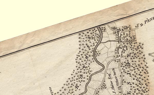 CLANY30S.jpg 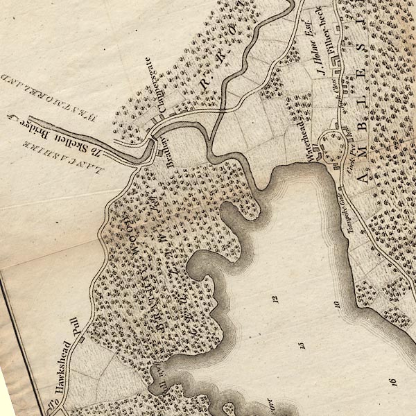 CLANY30R.jpg 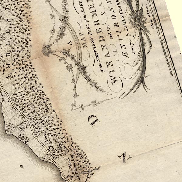 CLANY30W.jpg 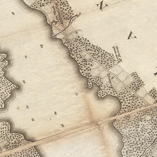 CLANY30V.jpg 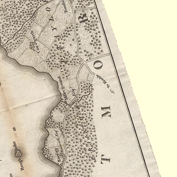 CLASD49E.jpg "To Kendale" item:- private collection : 10.10 Image © see bottom of page |
||||||||||||||||||||||||||||
|
|
|||||||||||||||||||||||||||||
| evidence:- | old map:- Cary 1789 (edn 1805) |
||||||||||||||||||||||||||||
| source data:- | Map, uncoloured engraving, Westmoreland, scale about 2.5 miles
to 1 inch, by John Cary, London, 1789; edition 1805. CY24NY30.jpg double line, bold light, numbered miles; main road item:- JandMN : 129 Image © see bottom of page |
||||||||||||||||||||||||||||
|
|
|||||||||||||||||||||||||||||
| evidence:- | road map:- Cary 1790 (Wmd/edn 1792) |
||||||||||||||||||||||||||||
| source data:- | Road map, hand coloured engraving, Westmoreland, scale about
11.5 miles to 1 inch, by John Cary, 181 Strand, London, 1790,
edn 1792. click to enlarge click to enlargeCY16.jpg no Windermere shown double line, with road distances from Kendal item:- JandMN : 44 Image © see bottom of page |
||||||||||||||||||||||||||||
|
|
|||||||||||||||||||||||||||||
| evidence:- | road book:- Cary 1798 (2nd edn 1802) |
||||||||||||||||||||||||||||
| source data:- | Road book, itineraries, Cary's New Itinerary, by John Cary, 181
Strand, London, 2nd edn 1802. goto source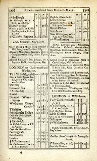 click to enlarge click to enlargeC38317.jpg page 317-318 "LONDON to Cockermouth and Workington" part of item:- JandMN : 228.1 Image © see bottom of page |
||||||||||||||||||||||||||||
|
|
|||||||||||||||||||||||||||||
| evidence:- | old map:- Cooke 1802 |
||||||||||||||||||||||||||||
| source data:- | Map, Westmoreland ie Westmorland, scale about 12 miles to 1
inch, by George Cooke, 1802, published by Sherwood, Jones and
Co, Paternoster Road, London, 1824. click to enlarge click to enlargeGRA1Wd.jpg though no Windermere, double line, light dark solid; road item:- Hampshire Museums : FA2000.62.4 Image © see bottom of page |
||||||||||||||||||||||||||||
|
|
|||||||||||||||||||||||||||||
| evidence:- | old map:- Laurie and Whittle 1806 |
||||||||||||||||||||||||||||
| source data:- | Road map, Completion of the Roads to the Lakes, scale about 10
miles to 1 inch, by Nathaniel Coltman? 1806, published by Robert
H Laurie, 53 Fleet Street, London, 1834. click to enlarge click to enlargeLw18.jpg bold line; 'Principal Travelling Roads' item:- private collection : 18.18 Image © see bottom of page |
||||||||||||||||||||||||||||
|
|
|||||||||||||||||||||||||||||
| evidence:- | old map:- Wallis 1810 (Wmd) |
||||||||||||||||||||||||||||
| source data:- | Road map, Westmoreland, scale about 19 miles to 1 inch, by James
Wallis, 77 Berwick Street, Soho, 1810, published by W Lewis,
Finch Lane, London, 1835? click to enlarge click to enlargeWAL5.jpg double line, light bold; 'Turnpike Road' item:- JandMN : 63 Image © see bottom of page |
||||||||||||||||||||||||||||
|
|
|||||||||||||||||||||||||||||
| evidence:- | old map:- Hall 1820 (Wmd) |
||||||||||||||||||||||||||||
| source data:- | Map, hand coloured engraving, Westmoreland ie Westmorland, scale
about 14.5 miles to 1 inch, by Sidney Hall, London, 1820,
published by Samuel Leigh, 18 Strand, London, 1820-31. click to enlarge click to enlargeHA18.jpg single line, solid; minor road; Applethwaite, Ambleside item:- Armitt Library : 2008.14.58 Image © see bottom of page |
||||||||||||||||||||||||||||
|
|
|||||||||||||||||||||||||||||
| evidence:- | old print:- Green 1822 (plate 1) |
||||||||||||||||||||||||||||
| source data:- | Print, uncoloured soft ground etching, Entrance from the South into Ambleside, Westmorland,
by William Green, Ambleside, Westmorland, 1822.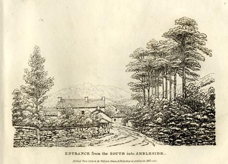 click to enlarge click to enlargeGN0801.jpg Plate 1 in Forty Etchings from Nature. printed at bottom:- "ENTRANCE from the SOUTH into AMBLESIDE. / Etched from Nature by William Green, &Published at Ambleside, Feby. 1, 1822." item:- Armitt Library : A6644.1 Image © see bottom of page |
||||||||||||||||||||||||||||
|
|
|||||||||||||||||||||||||||||
| evidence:- | descriptive text:- Otley 1823 (5th edn 1834) |
||||||||||||||||||||||||||||
| source data:- | Guide book, A Concise Description of the English Lakes, the
mountains in their vicinity, and the roads by which they may be
visited, with remarks on the mineralogy and geology of the
district, by Jonathan Otley, published by the author, Keswick,
Cumberland now Cumbria, by J Richardson, London, and by Arthur
Foster, Kirkby Lonsdale, Cumbria, 1823; published 1823-49,
latterly as the Descriptive Guide to the English Lakes. goto source Page 5:- "... All the way, ... to the head of the lake, the views are excellent; and every rising ground affords something new in the combination. ..." |
||||||||||||||||||||||||||||
|
|
|||||||||||||||||||||||||||||
| evidence:- | old print:- Westall 1830s |
||||||||||||||||||||||||||||
| source data:- | Print, aquatint panorama, Lake Windermere, from Low Wood Inn, Westmorland, drawn and
engraved by William Westall, published by Ackermann and Co, 96 Strand, London, 1830s.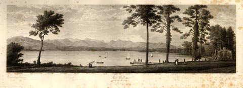 click to enlarge click to enlargeWTL307.jpg item:- Armitt Library : A6658.7 Image © see bottom of page |
||||||||||||||||||||||||||||
|
|
|||||||||||||||||||||||||||||
| evidence:- | descriptive text:- Ford 1839 (3rd edn 1843) |
||||||||||||||||||||||||||||
| source data:- | Guide book, A Description of Scenery in the Lake District, by
Rev William Ford, published by Charles Thurnam, Carlisle, by W
Edwards, 12 Ave Maria Lane, Charles Tilt, Fleet Street, William
Smith, 113 Fleet Street, London, by Currie and Bowman,
Newcastle, by Bancks and Co, Manchester, by Oliver and Boyd,
Edinburgh, and by Sinclair, Dumfries, 1839. goto source Page 160:- "..." "VII. KENDAL TO AMBLESIDE.- 13½M."
|
||||||||||||||||||||||||||||
|
|
|||||||||||||||||||||||||||||
| evidence:- | old map:- Ford 1839 map |
||||||||||||||||||||||||||||
| source data:- | Map, uncoloured engraving, Map of the Lake District of
Cumberland, Westmoreland and Lancashire, scale about 3.5 miles
to 1 inch, published by Charles Thurnam, Carlisle, and by R
Groombridge, 5 Paternoster Row, London, 3rd edn 1843. FD02SD49.jpg "A to K 13½Ms."  FD02NY30.jpg Distance Kendal to Ambleside; the old road ignores Windermere, which didn't much exist. item:- JandMN : 100.1 Image © see bottom of page |
||||||||||||||||||||||||||||
|
|
|||||||||||||||||||||||||||||
| evidence:- | possibly old drawing:- Aspland 1840s-60s |
||||||||||||||||||||||||||||
| source data:- | Drawing, pencil, road between Bowness and Low Wood, Westmorland, by Theophilus Lindsey
Aspland, 13 September 1849.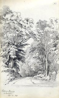 click to enlarge click to enlargeAS0141.jpg "Between Bowness / & Low Wood. / Septr. 13. 1849." item:- Armitt Library : 1958.487.41 Image © see bottom of page |
||||||||||||||||||||||||||||
|
|
|||||||||||||||||||||||||||||
| evidence:- | old map:- Garnett 1850s-60s H |
||||||||||||||||||||||||||||
| source data:- | Map of the English Lakes, in Cumberland, Westmorland and
Lancashire, scale about 3.5 miles to 1 inch, published by John
Garnett, Windermere, Westmorland, 1850s-60s. GAR2NY30.jpg double line, bold light, major road item:- JandMN : 82.1 Image © see bottom of page |
||||||||||||||||||||||||||||
|
|
|||||||||||||||||||||||||||||
| evidence:- | old map:- Prior 1874 map 1 |
||||||||||||||||||||||||||||
| source data:- | Map, uncoloured engraving or lithograph? Winander Mere, scale
about 2.5 miles to 1 inch, published by John Garnett,
Windermere, Westmorland, 1874. click to enlarge click to enlargePI03M1.jpg double line; road item:- private collection : 133.1 Image © see bottom of page |
||||||||||||||||||||||||||||
|
|
|||||||||||||||||||||||||||||
| evidence:- | gradient diagram:- Gall and Inglis 1890s-1900s (Roads) |
||||||||||||||||||||||||||||
| source data:- | Contour Road Book of England, Northern Division, by Harry R G Inglis, published by
Gall and Inglis, 25 Paternoster Square, London and Edinburgh, 1898.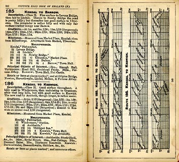 click to enlarge click to enlargeIG5185.jpg Itinerary, with gradient diagram, route 185, Kendal to Barrow, and route 187, Kendal to Keswick, Westmorland and Lancashire, 1898. item:- JandMN : 763.18 Image © see bottom of page |
||||||||||||||||||||||||||||
|
|
|||||||||||||||||||||||||||||
| evidence:- | gradient diagram:- Gall and Inglis 1890s-1900s (Roads) |
||||||||||||||||||||||||||||
| source data:- | Contour Road Book of England, Northern Division, by Harry R G Inglis, published by
Gall and Inglis, 25 Paternoster Square, London and Edinburgh, 1898.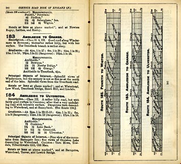 click to enlarge click to enlargeIG5183.jpg Itinerary, with gradient diagram, route 183, Ambleside to Grange, and route184, Ambleside to Ulverston, Westmorland and Lancashire, 1898. item:- JandMN : 763.17 Image © see bottom of page |
||||||||||||||||||||||||||||
|
|
|||||||||||||||||||||||||||||
| evidence:- | old text:- Gents Mag |
||||||||||||||||||||||||||||
| source data:- | Magazine, The Gentleman's Magazine or Monthly Intelligencer or
Historical Chronicle, published by Edward Cave under the
pseudonym Sylvanus Urban, and by other publishers, London,
monthly from 1731 to 1922. goto source Gentleman's Magazine 1900 part 2 p.356 "NIGHTS IN LAKELAND." "... If you are not likely to be nervous, and are not afraid of loneliness, cross the width of the district, say by the coach road from Windermere to Keswick, under cover of night, and you will fully understand the beauty of darkness. It was at one o'clock on a semi-dark June morning when I walked through Windermere village on this trip. Once clear of the houses, the rustle of the rabbits as they plunged deeper into the woods, the endless craik-craik-craik of the landrail, the occasional deep whistle of an otter from the beck or the lake, were the only sounds to break the silence. The lake was without a ripple as I passed along its shores at Lowwood, the night-glow reflected on its steel-like bosom; a charfisher sat in a motionless boat towards the middle of the lake, a disturbed white-throat scolded from the reed beds. I felt inclined to go no further - to sit down on the low wall here and wait for daybreak. Surely it would be a noble sight to watch the early sunbeams stream over Kentmere fells and light up this beautiful lake. Not a soul was astir as I passed through the market-place at Ambleside, but a man walked stealthily from a side street a little further on, and set off towards Rydal. ..." |
||||||||||||||||||||||||||||
|
|
|||||||||||||||||||||||||||||
| evidence:- | old strip map:- CTC 1911 (Roads) |
||||||||||||||||||||||||||||
| source data:- | Page 57 of Cyclists' Touring Club British Road Book new series vol.6, edited by F
B Sandford, published by Thomas Nelson and Sons, London etc, 1911.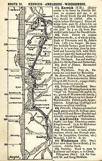 click to enlarge click to enlargeCTC257.jpg Strip road map, route 21, Keswick Ambleside Windermere, and Kendal, part of Silloth to Kendal, scale roughly 5 miles to 1 inch. Together with an itinerary and gradient diagram. item:- JandMN : 491.57 Image © see bottom of page |
||||||||||||||||||||||||||||
|
|
|||||||||||||||||||||||||||||
| evidence:- | gradient diagram:- Watson 1912 |
||||||||||||||||||||||||||||
| source data:- | Gradient diagram, black and white halftone, roads from Keswick, Cumberland, in a guide
book, Keswick on Derwentwater, published by George Watson, after 1913.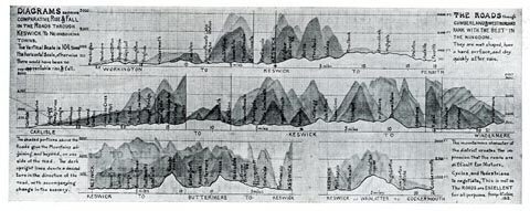 click to enlarge click to enlargeWT4Gd.jpg item:- Keswick Museum : 2145.5 Image © see bottom of page |
||||||||||||||||||||||||||||
|
|
|||||||||||||||||||||||||||||
| evidence:- | old map:- Burrow 1920s |
||||||||||||||||||||||||||||
| source data:- | Road book, On the Road, Dunlop Pictorial Road Plans, volume V,
strip maps with parts in Westmorland, Cumberland etc, irregular
scale about 1.5 miles to 1 inch, by E J Burrow and Co,
Cheltenham, Gloucestershire, 1920s. EJB3WtoA.jpg item:- private collection : 17 Image © see bottom of page |
||||||||||||||||||||||||||||
|
|
|||||||||||||||||||||||||||||
| evidence:- | old text:- Burrow 1920s placename:- |
||||||||||||||||||||||||||||
| source data:- | Road book, strip maps with parts in Westmorland, Cumberland etc,
irregular scales about 1.5 miles to 1 inch, by E J Burrow and
Co, Cheltenham, Gloucestershire, 1920s. "[from Windermere] ... The road runs close beside the lake to its northern end at Ambleside, with Langdale Pikes, showing up as the outstanding element in the glorious mountain country ahead. Across the lake to the left rise such famous peaks as Coniston Old Man (2,633 feet); farther away and more to the north the loftier forms of Scafell Pike (3,210 feet) and Scafell (3,162 feet). But closer at hand, right upon our course, is the beauty spot of Low Wood, on the shore of the lake, where steamers embark passengers for trips down the long narrow lake. ..." |
||||||||||||||||||||||||||||
|
|
|||||||||||||||||||||||||||||
 Act of Parliament Act of Parliament |
|||||||||||||||||||||||||||||
|
|
|||||||||||||||||||||||||||||
| evidence:- | old strip map:- Rumney 1899 |
||||||||||||||||||||||||||||
| source data:- | Road map, strip map, gradient diagram, and itinerary for Route I, Kendal to Keswick,
Westmorland and Cumberland, scale about 2 miles to 1 inch, by A W Rumney, published
by George Philip and Son, 32 Fleet Street, London, and Liverpool, 1899.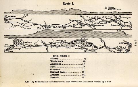 click to enlarge click to enlargeRUM103.jpg On p.14 of the Cyclist's Guide to the English Lake District, by A W Rumney. printed at top:- "Route I." item:- JandMN : 147.4 Image © see bottom of page |
||||||||||||||||||||||||||||
|
|
|||||||||||||||||||||||||||||
| evidence:- | old strip map:- Rumney 1899 |
||||||||||||||||||||||||||||
| source data:- | Road map, strip map, gradient diagram, and itinerary for Route II, Levens Bridge to
Ambleside via Lindale, Westmorland and Lancashire, scale about 2 miles to 1 inch,
by A W Rumney, published by George Philip and Son, 32 Fleet Street, London, and Liverpool,
1899.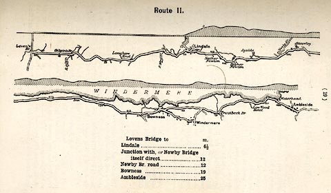 click to enlarge click to enlargeRUM104.jpg On p.19 of the Cyclist's Guide to the English Lake District, by A W Rumney. printed at top:- "Route II." item:- JandMN : 147.5 Image © see bottom of page |
||||||||||||||||||||||||||||
|
|
|||||||||||||||||||||||||||||
| evidence:- | old photograph:- Bell 1880s-1940s |
||||||||||||||||||||||||||||
| source data:- | Photograph, near Waterhead, Ambleside, by Herbert Bell, Ambleside, Westmorland, 1890s?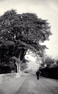 click to enlarge click to enlargeHB0255.jpg item:- Armitt Library : ALPS29 Image © see bottom of page |
||||||||||||||||||||||||||||
|
|
|||||||||||||||||||||||||||||
| places:- | Windermere Troutbeck Bridge, Windermere Low Wood Hotel, Lakes Ambleside |
||||||||||||||||||||||||||||
|
|
|||||||||||||||||||||||||||||
| places:- |
|
||||||||||||||||||||||||||||
|
|||||||||||||||||||||||||||||
|
|||||||||||||||||||||||||||||
|
|||||||||||||||||||||||||||||
|
|||||||||||||||||||||||||||||
|
|||||||||||||||||||||||||||||
Lakes Guides menu.