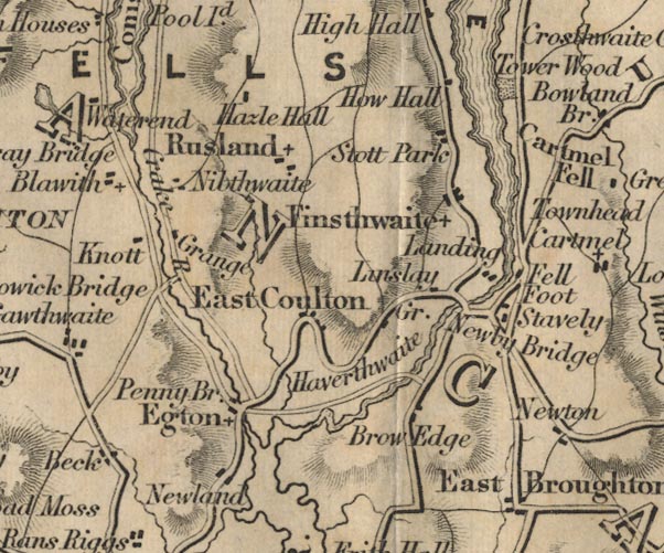
 Ford 1839 map SD38


|

|
|
|
gazetteer links places may or may not be labelled on the map |
||

|
-- Bouth -- "East Coulton" |
|
|
|
-- Crake, River -- "Crake R." |
|
|
|
-- Fell Foot -- "Fell Foot" |
|
|
|
-- Finsthwaite -- "Finsthwaite" |
|
|
|
-- Furness Fells -- "FURNESS FELLS" |
|
|
|
-- Graythwaite Old Hall -- "How Hall" |
|
|
|
-- Great Knott -- "Knott" |
|
|
|
-- Greenodd -- "Egton" |
|
|
|
-- Haverthwaite -- "Haverthwaite" |
|
|
|
-- Hazel Hall -- "Hazle Hall" |
|
|
|
-- High Brow Edge -- "Brow Edge" |
|
|
|
-- High Stott Park -- "Stott Park" |
|
|
|
-- Landing How -- "Landing" |
|
|
|
-- Linsty Green -- "Linslay Gr." |
|
|
|
-- Low Nibthwaite -- "Nibthwaite" |
|
|
|
-- Lowick Bridge -- "Lowick Bridge" |
|
|
|
-- Newby Bridge -- "Newby Bridge" |
|
|
|
-- Newland -- "Newland" |
|
|
|
-- Nibthwaite Grange -- "Grange" |
|
|
|
-- Penny Bridge -- "Penny Bridge" |
|
|
|
-- Newby Bridge to Ulverston |
|
|
|
-- Rusland -- "Rusland" |
|
|
|
-- Staveley-in-Cartmel -- "Stavely" |
|
|
|
-- Town Head -- "Townhead" |
|
|
|
-- Windermere lake -- "Tower Wood"-- Windermere lake |
|
|
civil parishes The area roughly includes parts of parishes:- Cartmel Fell Lower Allithwaite Broughton East Haverthwaite Colton Lowick Hawkshead Egton with Newland Staveley-in-Cartmel Upper Allithwaite Windermere Satterthwaite |
||
|
|
||
|
|
Lakes Guides menu. | |