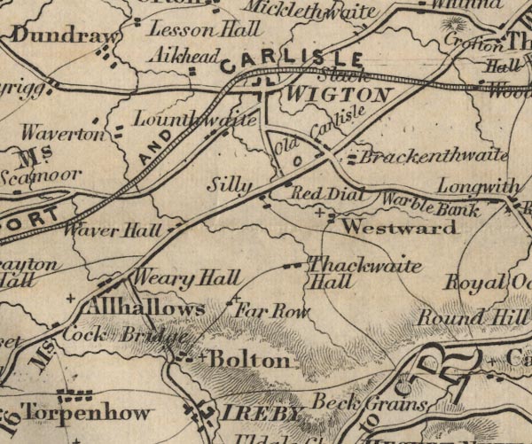
 Ford 1839 map NY24


|

|
|
|
gazetteer links places may or may not be labelled on the map |
||

|
-- Aikhead -- "Aikhead" |
|
|
|
-- Allhallows -- "Allhallows" |
|
|
|
-- Boltongate -- "Bolton" |
|
|
|
-- Brackenthwaite -- "Brackenthwaite" |
|
|
|
-- Dundraw -- "Dundraw" |
|
|
|
-- Far Row -- "Far Row" |
|
|
|
-- Low Longthwaite -- "Lounthwaite" |
|
|
|
-- Maryport and Carlisle Railway -- "MARYPORT AND CARLISLE
RAILWAY" |
|
|
|
-- Old Carlisle -- "Old Carlisle" |
|
|
|
-- Red Dial -- "Red Dial" |
|
|
|
-- Cockermouth to Carlisle -- "C to W 16 Ms." --
"W to C 11" |
|
|
|
-- Keswick to Wigton -- "K to W 22 Ms." |
|
|
|
-- Penrith to Wigton -- "W to P 21 Ms." |
|
|
|
-- Silly -- "Silly" |
|
|
|
-- Slack -- "Slack" |
|
|
|
-- Thackthwaite Hall -- "Thackthwaite Hall" |
|
|
|
-- Warblebank -- "Warble Bank" |
|
|
|
-- Waver Bank -- "Waver Hall" |
|
|
|
-- Weary Hall -- "Weary Hall" |
|
|
|
-- Westward -- "Westward" |
|
|
|
-- Wigton -- "WIGTON" |
|
|
civil parishes The area roughly includes parts of parishes:- Blennerhasset and Torpenhow Westward Boltons Waverton Wigton Woodside Thursby Caldbeck Ireby Bromfield Allhallows Dundraw |
||
|
|
||
|
|
Lakes Guides menu. | |