 Speed 1611
 |
 |
|
|
Places Identified
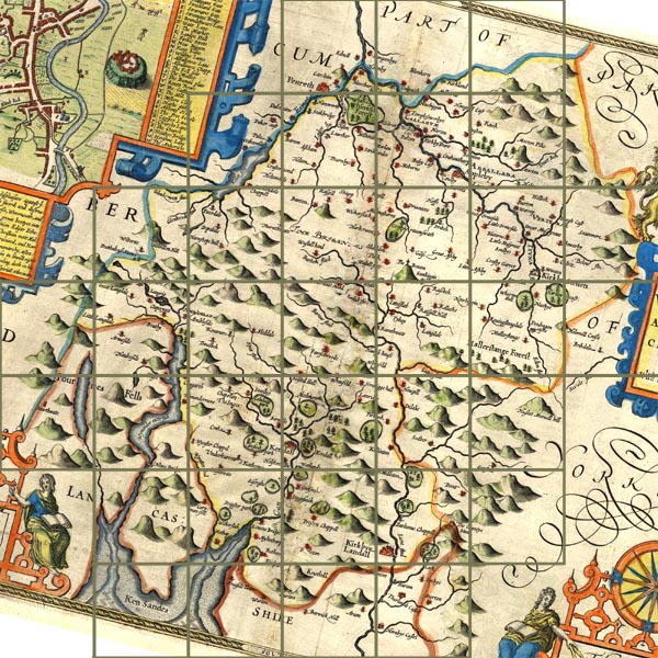
Map, hand coloured engraving, The Countie Westmorland and Kendale the Cheif Towne, scale about 2.5 miles to 1 inch, by John Speed, 1610, published by George Humble, Popes Head Alley, London, 1611-12. NB: each image includes an overlap, places in the overlap are not listed. The images are roughly equivalent to ngr 10Km squares and are listed from top left to bottom right. | ||
 ScSP14x.jpg
 | ||
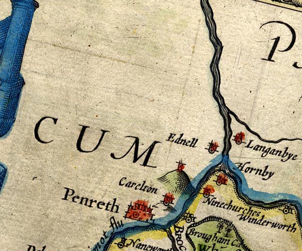 SP14NY53.jpg
 |
Brougham Castle -- castle -- NY537290
-- 'Brougham Ca' -- circle, buildings and tower
Carleton -- building/s -- NY5329 -- 'Carelton' -- circle, towers Eamont, River -- river -- NY469243 (from) ? ? -- 'Eimot flu' -- running into the Eden -- double line with stream lines; county boundary Edenhall -- building/s -- NY565324 -- 'Ednell' -- circle, towers Hornby Hall -- building/s -- NY56952995 ? ? -- 'Hornby' -- circle, towers Langwathby -- building/s -- NY5633 -- 'Langanbye' -- circle, building and tower Penrith Beacon -- hill -- beacon -- NY52123138 -- tower on a hillock Penrith -- building/s etc -- NY513304 -- 'Penreth' -- buildings and towers Robberby Water -- river -- NY561359 -- stream running into the Eden probably St Ninian's Church -- church -- NY55932995 -- 'Ninechurches' -- circle, tower | |
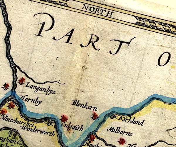 SP14NY63.jpg
 |
Blencarn -- building/s -- NY6331
-- 'Blenkern' -- circle, building and tower
Culgaith -- building/s -- NY6129 -- 'Culgaith' -- circle, building and tower Kirkland -- building/s -- NY646325 -- 'Kirkland' -- circle, building and tower Winderwath -- locality -- NY6510 (?) -- 'Winderworth' -- circle, building and tower | |
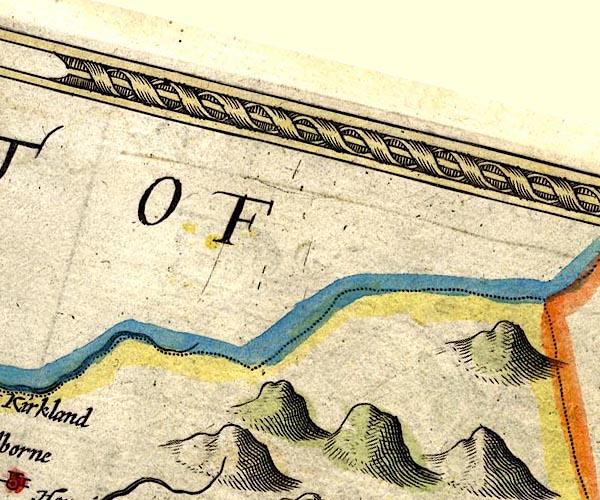 SP14NY73.jpg
 |
Pennines, The -- hill -- NY55
-- hillocks -- hillocks -- hillocks
| |
 SP14NY42.jpg
 |
Aira Beck -- river -- NY40001974
-- double line, into Ullswater
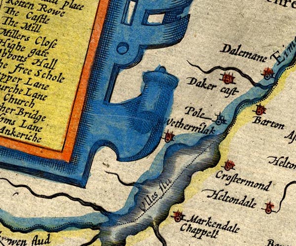
Cross Dormont -- building/s -- NY46182250 -- 'Crostermond' -- circle, building and tower Dacre Castle -- castle -- haunted house -- NY46052650 -- 'Daker cast' -- circle, towers Parkhouse Gill -- river -- NY42592068 ? ? -- double line, into Ullswater probably Pooley Bridge -- building/s etc -- NY472244 -- 'Pole' -- circle, building and tower St Martin's Church -- church -- NY43421840 -- 'Markendale Chappell' -- circle, building and tower Ullswater -- lake -- NY422202 (etc) ? -- 'Ulles flu' -- outline, shore shaded; county boundary through lake Watermillock -- building/s -- NY445224 -- 'Wetherm'lak' -- circle, towers | |
 SP14NY52.jpg
 |
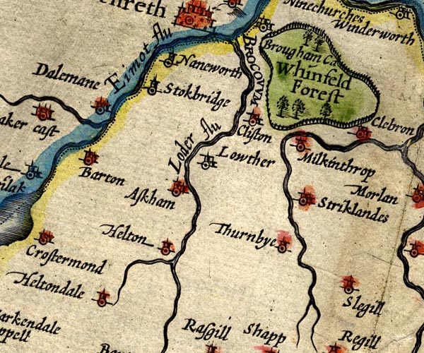
Askham -- building/s -- NY513237
-- 'Askham' -- circle, building and tower
Barton -- building/s -- NY486264 -- 'Barton' -- circle, building and tower Clifton -- building/s -- NY534266 -- 'Clifton' -- circle, building and tower Dacre Beck -- river -- NY4626 -- double line tapering to wiggly line, running into the Eamont Dalemain -- park -- building/s -- museum -- garden -- NY479269 -- 'Dalemane' -- circle, towers Eamont, River -- river -- NY469243 (from) ? ? -- 'Eimot flu' -- running into the Eden -- double line with stream lines; county boundary Great Strickland -- building/s -- NY5522 ? -- 'Striklandes' -- circle, building and tower Helton -- building/s -- NY510220 -- 'Helton' -- circle, tower Heltondale Beck -- river -- NY51522025 -- double line tapering to wiggly line, running into the Lowther Heltondale -- building/s -- NY501208 -- 'Heltondale' -- circle, tower Little Strickland -- building/s -- NY563197 ? -- 'Striklandes' -- circle, building and tower Lowther -- building/s -- NY536236 -- 'Lowther' -- circle, building and tower Lowther, River -- river etc -- NY5124 (etc) -- 'Loder flu' -- double line with stream lines Melkinthorpe -- building/s -- NY55562522 -- 'Milkinthrop' -- circle, tower Brocavum -- roman fort -- NY5328 ? -- 'BROCOVUM' -- no symbol Sleagill -- building/s -- NY595191 -- 'Slegill' -- circle, tower Sockbridge -- building/s -- NY500267 -- 'Stokbridge' -- circle, tower Thrimby -- building/s -- NY5520 -- 'Thurnbye' -- circle, tower Whinfell Forest -- forest -- wood -- NY5727 (etc) -- 'Whinfeld Forest' -- circle of fence palings, trees Yanwath -- building/s -- NY5127 -- 'Naneworth' -- circle, tower | |
 SP14NY62.jpg
 |
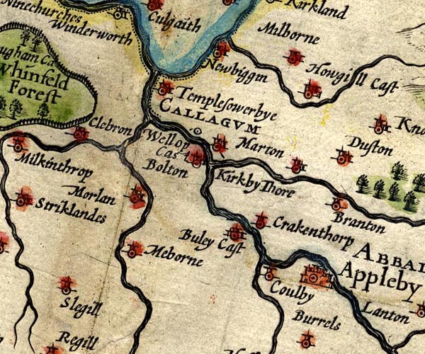
Appleby-in-Westmorland -- building/s etc -- NY684204
-- 'Appleby / ABBALLABA' -- circle, buildings and towers
Bewley Castle -- castle (remains) -- pele tower (?) -- NY64822115 -- 'Buley Cast' -- circle, buildings, tower Bolton -- building/s -- NY638232 -- 'Bolton' -- circle, tower Brampton -- building/s -- NY680233 -- 'Branton' -- circle, tower Cliburn -- building/s -- NY5824 -- 'Clebron' -- circle, building and tower Colby -- building/s -- NY666204 -- 'Coulby' -- circle, tower Crackenthorpe -- building/s -- NY661221 ? -- 'Crakenthorp' -- circle, tower Crowdundle Beck -- river -- boundary -- parish boundary -- county boundary (once) -- NY6228 (etc) -- double line, running into the Eden Dufton -- building/s -- NY689251 -- 'Dufton' -- circle, building and tower Eden, River -- river -- NY3658 (etc) -- 'ITUNA flu' -- 'Eden flud' -- double line -- double line -- double line Hoff Beck -- river -- NY6717 (etc) -- double line, running into the Eden Howgill Castle -- building/s -- NY66562927 -- 'Howgill Cast' -- circle, towers King's Meaburn -- building/s -- NY620212 ? -- 'Meborne' -- circle, tower Kirkby Thore -- building/s -- NY638256 -- 'Kirkby Thore' -- circle, building and tower; noice the line indicating the label Leith, River -- river -- NY5523 -- double line, running into the Lyvennet Long Marton -- building/s -- NY666246 ? -- 'Marton' -- circle, building and tower Lyvennet, River -- river -- NY6121 (etc) -- double line, running into the Eden Milburn Beck -- river -- NY6528 (etc) -- double line, running into the Crowdundle Beck Milburn -- building/s -- NY655293 -- 'Milborne' -- circle, building and tower Morland -- building/s etc -- NY598225 -- 'Morlan' -- circle, building and tower Newbiggin -- building/s -- NY628285 -- 'Newbiggin' -- circle, building and tower Gallatum (?) -- roman fort -- NY63802560 -- 'CALLAGUM / Wellop Cas' -- circle Temple Sowerby -- building/s -- NY611271 -- 'Templesowerbye' -- circle, building and tower Trout Beck -- river -- boundary -- NY6624 (etc) -- double line, running into the Eden Whelp Castle -- castle (site) -- NY637256 -- 'CALLAGUM / Wellop Cas' -- circle; notice the line towards the label | |
 SP14NY72.jpg
 |
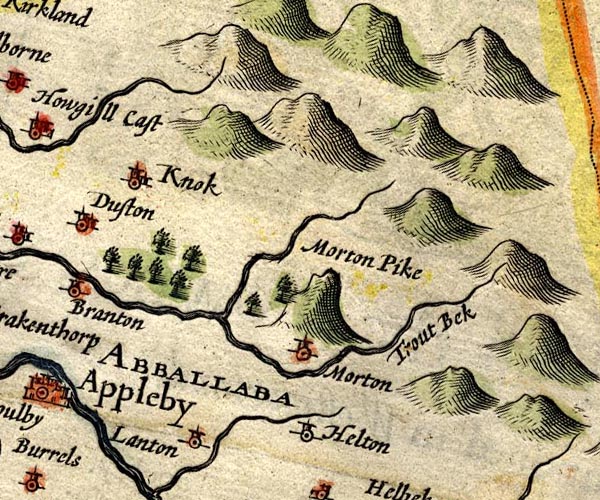
forest, Dufton -- wood -- forest -- NY6825 (approx)
-- group of trees
High Cupgill Beck -- river -- boundary -- parish boundary -- NY7325 (etc etc) -- double line, running into the Trout Beck Hilton -- building/s -- NY734207 -- 'Helton' -- circle, tower Knock -- building/s -- NY680270 -- 'Knok' -- circle, building and tower Langton -- building/s -- NY709201 -- 'Lanton' -- circle, tower Murton Beck -- river -- NY7221 -- 'Trout Bek' -- double line, running into the Trout Beck Murton Pike -- hill -- NY73392312 -- 'Morton Pike' -- tall hillock Murton -- building/s -- NY7221 -- 'Morton' -- circle, tower Pennines, The -- hill -- NY55 -- hillocks -- hillocks -- hillocks | |
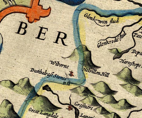 SP14NY31.jpg
 |
Dunmail Raise Stones -- cairn -- NY32721167
-- 'Dunbalrase Stones' -- two standing stones; on county
boundary
Easedale Beck -- river -- NY336081 -- double line, from tarn to Grasmere Easedale Tarn -- lake -- NY307087 (etc) -- outline, shaded Glencoyne Beck -- river -- boundary -- county boundary -- NY38751881 ? -- 'Glank[ ]wen flud' -- double line, into Ullswater; county boundary -- double line, into Ullswater Glenridding Beck -- river -- NY35971603 ? -- 'Glenkrode flud' -- double line -- double line, into Ullswater Helvellyn -- hill -- NY34261508 -- 'Helvillon Hill' -- large hillock Raise Beck -- river -- NY3211 -- double line, into Easedale Beck Wythburn -- locality -- NY322130 (etc) -- 'Wiborne' -- circle, tower | |
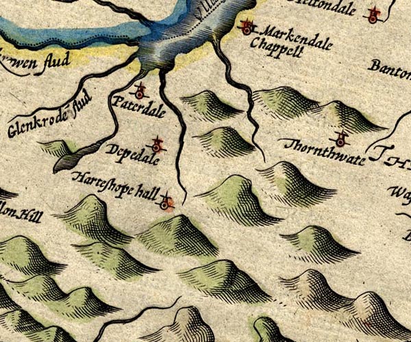 SP14NY41.jpg
 |
Deepdale -- valley -- NY390132
-- 'Deepdale' -- circle, tower
Glencoyne Beck -- river -- boundary -- county boundary -- NY38751881 ? -- 'Glank[ ]wen flud' -- double line, into Ullswater; county boundary -- double line, into Ullswater Glenridding Beck -- river -- NY35971603 ? -- 'Glenkrode flud' -- double line -- double line, into Ullswater Goldrill Beck -- river -- NY393166 -- double line, into Ullswater Grisedale Beck -- river -- NY36451437 ? -- double line, from tarn to Ullswater Hartsop Hall (?) -- building/s -- NY39861202 -- 'Harteshope hall' -- circle, tower Howegrain Beck -- river -- NY44321990 ? -- double line, into Ullswater Patterdale -- building/s -- NY394160 -- 'Paterdale' -- circle, tower Thornthwaite Hall -- building/s -- park (?) -- NY51281630 -- 'Thornthwaite' -- circle, tower | |
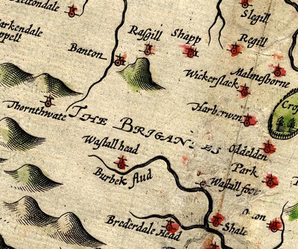 SP14NY51.jpg
 |
Bampton Grange -- building/s -- NY521180 ?
-- 'Banton' -- circle, building and tower
Birk Beck -- river -- NY5808 -- 'Burbek flud' -- double line -- double line, into the Lune Bretherdale Beck -- river -- NY5804 (etc) -- double line, into the Birk Beck Harberwain -- building/s -- NY60731504 -- 'Harberwen' -- circle, tower High Scales -- building/s -- NY597068 ? -- 'Shale' -- circle, tower probably Low Scales -- building/s -- NY600055 ? -- 'Shale' -- circle, tower probably Reagill -- building/s -- NY603176 -- 'Regill' -- circle, tower Rosgill -- building/s -- NY537167 -- 'Rasgill' -- circle, tower Shap -- building/s etc -- NY562153 -- 'Shapp' -- circle, building and tower Wasdale Foot (?) -- building/s (gone?) -- NY5709 (?) -- 'Wastall foot' -- circle, tower Wasdale Head -- building/s -- NY55010817 -- 'Wastall head' -- circle, tower Wickerslack -- building/s -- NY608156 -- 'Wickerslack' -- circle, tower | |
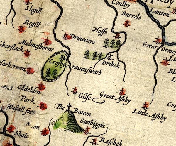 SP14NY61.jpg
 |
Burrells -- building/s -- locality -- NY680182
-- 'Burrels' -- circle, tower
Crosby Ravensworth -- building/s -- NY622148 -- 'Crosbyeravenswath' -- circle, building and tower Dry Beck -- river -- NY4269 (etc) ? -- wiggly line, into the Hoff Beck Drybeck -- building/s -- NY665153 -- 'Dribek' -- circle, tower Dryevers -- building/s -- NY64531744 -- 'Drivevers' -- circle, tower Gilts -- building/s -- NY62661184 ? -- 'Gilse' -- circle, tower Great Asby -- building/s -- NY680131 -- 'Great Ashby' -- circle, tower Hoff -- building/s -- NY675176 -- 'Hoffe' -- circle, tower Little Asby -- building/s -- NY698096 -- 'Little Ashby' -- circle,tower Maulds Meaburn -- building/s -- NY624168 -- 'Malmesborne' -- circle, tower Oddendale -- building/s -- locality -- NY594134 -- 'Oddelden' -- circle, tower Orton Beacon -- beacon -- NY63300997 ? -- 'The Beacon' -- post and cresset? on a hillock park, Crosby Ravensworth -- park -- NY6214 -- ring of fance palings, trees, a park Park -- building/s -- NY61250892 -- 'Park' -- circle, tower | |
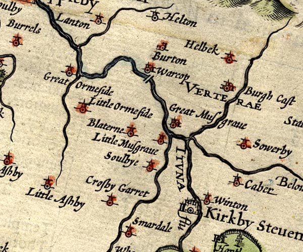 SP14NY71.jpg
 |
Belah, River -- river -- boundary etc -- NY7912 (etc)
?
-- 'Below flu' -- double line, into the Eden -- wiggly line
Bleatarn -- building/s -- NY732138 -- 'Blaterne' -- circle, tower Brough Castle -- castle -- NY791141 -- 'Burgh Cast' -- circle, buildings and tower Brough Sowerby -- building/s -- NY793128 -- 'Sowerby' -- circle, tower Burton -- locality -- building/s (once) -- NY744185 -- 'Burton' -- circle, building and tower Crosby Garrett -- building/s -- NY728094 (etc) -- 'Crosby Garret' -- circle, tower Eden, River -- river -- NY3658 (etc) -- 'ITUNA flu' -- 'Eden flud' -- double line -- double line -- double line Great Ormside -- building/s -- NY701173 -- 'Great Ormeside' -- circle, tower Helbeck -- building/s -- NY794155 -- 'Helbek' -- circle, tower Helm Beck -- river -- NY7015 (etc) -- double line, into the Eden Hilton Beck -- river -- NY7220 (etc) -- double line, into the Eden Kaber -- building/s -- NY797115 -- 'Caber' -- circle, tower Kirkby Stephen -- building/s etc -- NY775086 -- 'Kirkby Steven' -- circle, buildings and towers Little Musgrave -- building/s -- NY759131 ? -- 'Little Musgrave' -- circle, tower Little Ormside -- building/s -- NY708167 ? -- 'Little Ormeside' -- circle, tower Scandal Beck -- river -- boundary -- NY7207 (etc) -- double line, into the Eden Soulby -- building/s -- NY749111 -- 'Soulbye' -- circle, tower Swindale Beck -- river -- boundary -- NY6928 (etc) -- double line, into the Eden Warcop -- building/s -- NY749155 -- 'Warcop' -- circle, building and tower Winton -- building/s -- NY784106 -- 'Winton' -- circle, tower | |
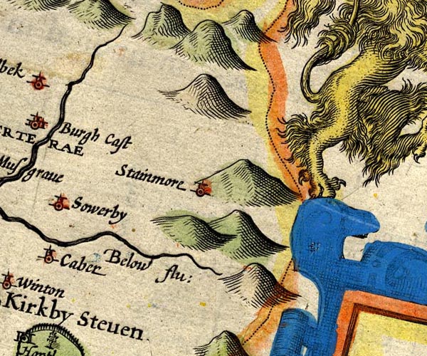 SP14NY81.jpg
 |
Belah, River -- river -- boundary etc -- NY7912 (etc)
?
-- 'Below flu' -- double line, into the Eden -- wiggly line
Pennines, The -- hill -- NY55 -- hillocks -- hillocks -- hillocks Stainmore -- locality -- valley -- NY81 -- 'Stainmore' -- circle, tower | |
 SP14NY20.jpg
 |
Furness Fells -- hill -- fell -- SD3389 (etc)
-- 'Fournes Fells' -- hillocks
| |
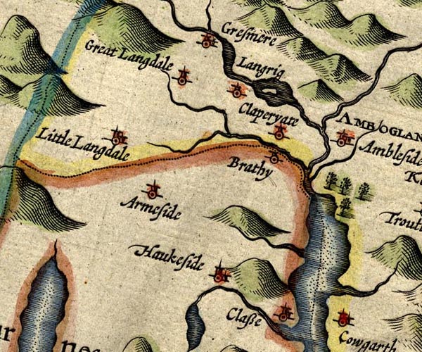 SP14NY30.jpg
 |
Ambleside -- building/s etc -- NY376045 ?
-- 'Ambleside / AMBOGLAN' -- circle, building and tower
Blelham Beck -- river -- NY370018 -- double line, into Windermere Brathay, River -- river -- NY3503 -- double line, into Windermere; county boundary Clappersgate -- building/s -- NY366033 -- 'Claperyate' -- circle, tower Grasmere -- building/s -- NY336075 ? -- 'Gresmere' -- circle, building and tower Great Langdale Beck -- river -- NY3105 -- wiggly line, into the Brathay Great Langdale -- building/s -- valley -- NY313055 (etc) -- 'Great Langdale' -- circle, tower Hawkshead -- building/s etc -- SD351980 -- 'Haukeside' -- circle, building and tower High Arnside -- building/s -- NY33230170 ? ? -- 'Armeside' -- circle, tower possibly Little Langdale -- building/s -- locality -- NY315034 -- 'Little Langdale' -- circle, building and tower Loughrigg -- locality -- NY3405 (?) ? -- 'Langrig' -- circle, tower Low Arnside -- building/s -- NY33360190 ? ? -- 'Armeside' -- circle, tower possibly Old Brathay -- building/s -- locality -- NY366033 -- 'Brathy' -- circle, tower Rothay, River -- river -- NY3308 (etct) -- double line, from Rydal Water into Grasmere, from thence into Windermere Scandale Beck -- river -- NY3707 -- double line, into the Rothay Stock Ghyll -- river -- NY3905 -- wiggly line, into the Rothay Strawberry Wood -- wood -- NY382035 ? -- group of trees perhaps Trout Beck -- river -- NY4104 (etc) ? -- double line, into Windermere Windermere lake -- lake -- SD392950 ? -- 'Wynander mere flud' -- outline, shore shaded, interior pecked; county boundary through the middle | |
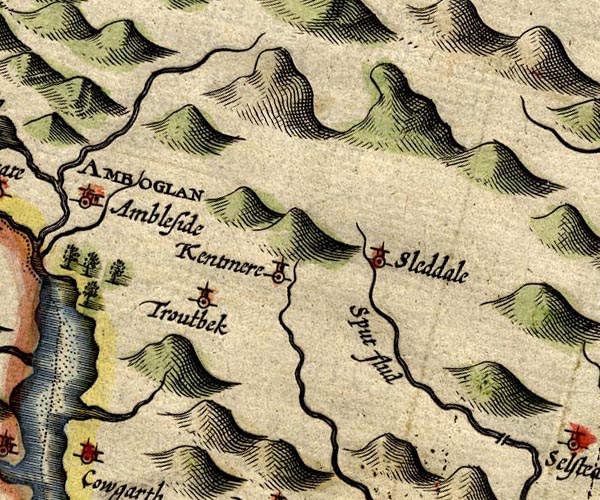 SP14NY40.jpg
 |
Kentmere -- valley -- NY457040 (etc)
-- 'Kentmere' -- circle, tower
Longsleddale -- valley -- NY4904 (etc) -- 'Sleddale' -- circle, tower Sprint, River -- river -- NY4806 (etc) -- 'Sput flud' -- double line -- double line, into the Kent Troutbeck -- building/s -- locality -- valley -- NY4103 -- 'Troutbek' -- circle, tower | |
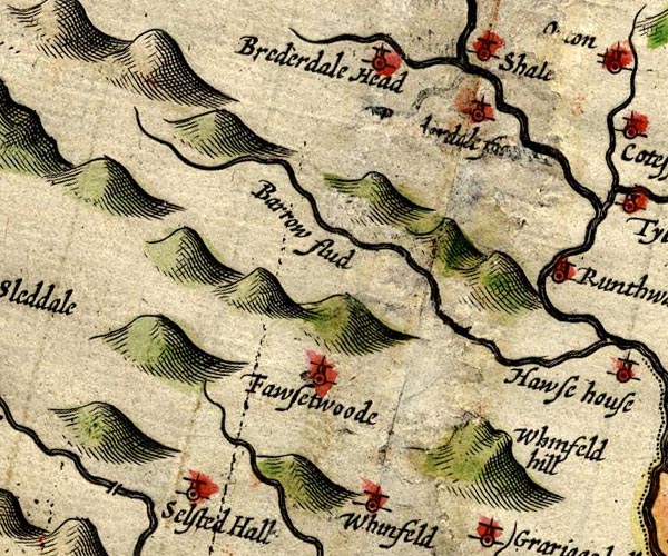 SP14NY50.jpg
 |
Borrow Beck -- river -- NY5503
-- 'Barrow flud' -- double line -- double line, into the
Lune
Bretherdale Foot -- building/s -- NY596043 -- '[Brederdale foot]' -- circle, tower Bretherdale Head -- building/s -- NY5705 -- 'Brederdale Head' -- circle, tower Fawcett Forest -- locality -- NY5303 (etc) -- 'Fawsetwoode' -- circle, tower Garnett Bridge -- bridge -- SD52369927 ? -- double line across the Sprint, bridge probably Selside Hall -- building/s -- haunted house -- SD53459904 ? -- 'Selsted Hall' -- circle, tower Whinfell Beacon -- hill -- beacon -- NY57350029 -- 'Whinfeld hill' -- hillock | |
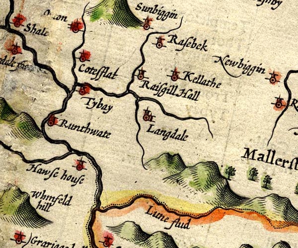 SP14NY60.jpg
 |
Birk Beck -- river -- NY5808
-- 'Burbek flud' -- double line -- double line, into the
Lune
Borrow Beck -- river -- NY5503 -- 'Barrow flud' -- double line -- double line, into the Lune Carlin Gill -- river -- valley -- SD6399 (etc) -- 'Lune flud' -- double line, into the Lune; county boundary Chapel Beck -- river -- NY2331 -- double line, into the Lune Coatsforth -- locality -- township -- NY695124 (etc, roughly) -- 'Cotesflat' -- circle, tower Hawse House (?) -- building/s -- NY608006 -- 'Hawse house' -- circle, tower Kelleth -- building/s -- NY661052 -- 'Kellathe' -- circle, tower Langdale Beck -- river -- NY6402 (etc) -- double line, into the Lune Longdale -- building/s -- NY644041 -- 'Langdale' -- circle, building and tower Orton -- building/s etc -- NY621083 -- 'Orton' -- circle, building and tower Rais Beck -- river -- NY6407 (etc) -- double line, into the Lune Raisbeck -- building/s -- NY645075 -- 'Rasebeck' -- circle, tower Raisgill Hall -- building/s -- NY635058 -- 'Raisgill Hall' -- circle, tower Roundthwaite -- building/s -- NY608023 -- 'Runthwate' -- circle, tower Sunbiggin -- building/s -- NY658086 -- 'Sunbiggin' -- circle, tower Tebay -- building/s -- NY616045 -- 'Tybay' -- circle, tower | |
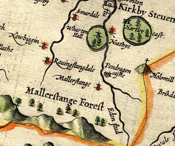 SP14NY70.jpg
 |
Eden, River -- river -- NY3658 (etc)
-- 'ITUNA flu' -- 'Eden flud' -- double line -- double line
-- double line
Gale Sike -- river -- NY7902 (etc) -- double line, into the Eden perhaps Hartley Castle -- castle -- park (?) -- NY78250820 -- 'Hartley cast.' -- circle, towers, and tree symbols in a ring of fence palings for the park Mallerstang Forest -- forest -- NY70 (?) & SD79 (?) -- 'Mallerstang Forest' -- group of tree symbols, north of a range of hillocks Mallerstang -- locality -- NY7801 (etc) -- 'Mallerstange' -- circle, tower Nateby -- building/s -- NY775068 -- 'Neathye' -- circle, tower Newbiggin-on-Lune -- building/s -- NY705051 -- 'Newbiggin' -- circle, tower Pendragon Castle -- castle -- NY78180263 -- 'Pendragon castle' -- circle, towers Ravenstonedale -- building/s etc -- NY723039 -- 'Ravingstangdale' -- circle, tower Smardale -- building/s -- NY739080 (etc) -- 'Smardale' -- circle, tower Wharton Hall -- building/s -- park -- NY77090616 -- 'Wharton Hall' -- circle, tower, and tree symbols in a ring of fence palings for the park | |
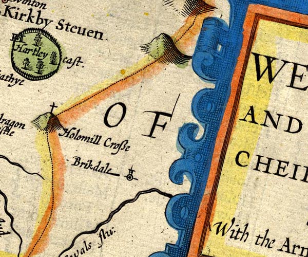 SP14NY80.jpg
 |
Birkdale -- building/s -- NY8501
-- 'Brikdale' -- circle, tower
Hollow Mill Cross -- boundary stone -- NY81180405 -- 'Holomill Crosse' -- cross on a hilloc; on the county boundary Swale, River -- river -- NY80 (etc) -- 'Swals flu:' -- double line, flowing east | |
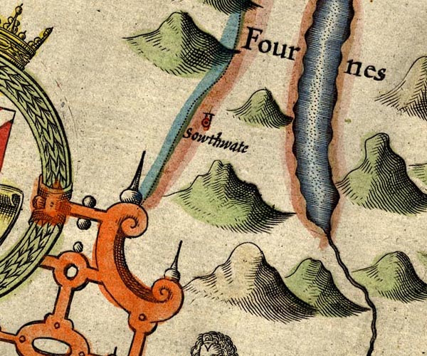 SP14SD29.jpg
 |
Coniston Water -- lake -- SD302943
-- outline, shore shaded, interior pecked
Furness Fells -- hill -- fell -- SD3389 (etc) -- 'Fournes Fells' -- hillocks Seathwaite -- building/s -- SD227960 ? -- 'Sowthate' -- circle, tower | |
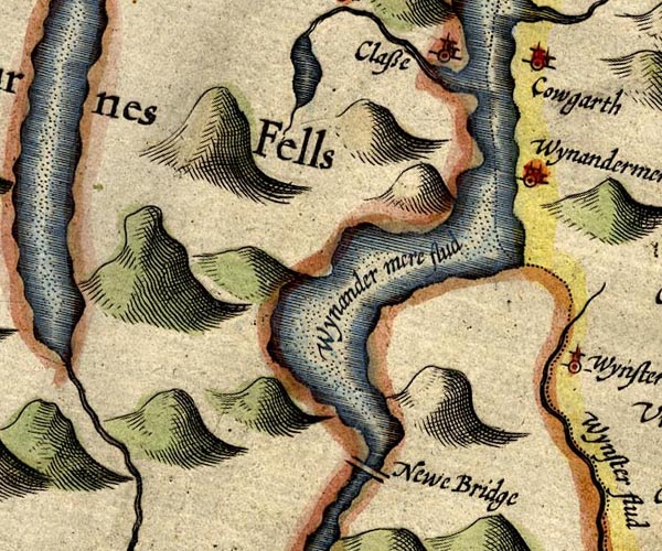 SP14SD39.jpg
 |
Bowness-on-Windermere -- building/s etc -- SD403969 ?
-- 'Wynandermere' -- circle, buildings
Calgarth Hall -- building/s -- haunted house -- SD398996 ? -- 'Cowgarth' -- circle, buildings Claife -- area -- SD3798 (etc) -- 'Classe' -- circle, building and tower Cunsey Beck -- river -- boundary -- parish boundary -- SD3694 -- double line, north from Esthwaite Water, into Windermere Esthwaite Water -- lake -- SD3696 (etc) -- outline, shore shaded, interior pecked; drained by a stream northward Furness Fells -- hill -- fell -- SD3389 (etc) -- 'Fournes Fells' -- hillocks Newby Bridge -- bridge -- SD36918636 ? -- 'Newe Bridge' -- double line across the Leven Windermere lake -- lake -- SD392950 ? -- 'Wynander mere flud' -- outline, shore shaded, interior pecked; county boundary through the middle | |
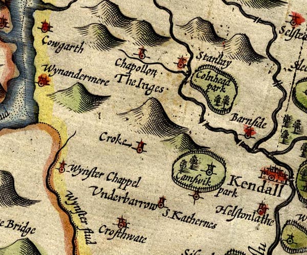 SP14SD49.jpg
 |
Bowston Bridge -- bridge -- SD49869660 ?
-- double line across the Kent, bridge
bridge, Burneside -- bridge -- SD50529580 ? -- double line across the Kent, bridge by Burneside Burneside -- building/s -- SD505955 -- 'Barnside' -- circle, tower Crook -- building/s -- SD464951 -- 'Croke' -- circle, tower Crosthwaite -- building/s -- SD437915 -- 'Crosthwaite' -- circle, building and tower Cunswick Hall -- building/s -- park -- SD48579326 -- 'Camswik park' -- circle, tower, in a ring of fence palings, trees, for the park Gowan, River -- river -- SD4598 -- wiggly line, into the Kent Ings -- building/s -- SD445986 -- 'Chapollon The Inges' -- circle, tower; note that the text engraving suggest two separate labels, cf Blaeu's copying as two places Clonhead Park -- park -- SD4997 -- 'Colnhead park' -- ring of fence palings, trees St Catherine's Church -- church (remains) -- tower -- SD45009467 -- 'S. Katherines' -- circle Staveley -- building/s etc -- SD470984 -- 'Stanlay' -- circle, tower Underbarrow -- building/s -- SD465922 -- 'Underbarrow' -- circle, tower Winster -- building/s -- SD418935 -- 'Wynster Chappel' -- circle, tower Winster, River -- river -- SD4285 (etc) -- 'Wynster flud' -- double line; county boundary -- double line, into the Kent Estuary; county boundary | |
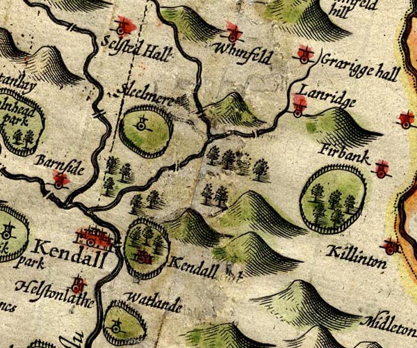 SP14SD59.jpg
 |
Docker Bridge -- bridge -- SD56559630
-- double line across Lambrigg Beck probably
Grayrigg Hall -- building/s -- SD57949750 -- 'Grarigge hall' -- circle, tower Helsington Laithes -- building/s -- SD50629070 ? -- 'Helstonlathe' -- circle, building and tower Kendal Castle -- castle -- SD521924 -- 'Kendal [ t]' -- circle, buildings, tower, and a ring of fence palings and trees for a park Kendal -- building/s etc -- SD514926 -- 'Kendall' -- circle, buildings and towers Lambrigg Beck (?) -- river -- boundary -- parish boundary -- SD5696 (etc) ? ? -- double line, into the Mint Lambrigg -- locality -- SD5895 -- 'Lanridge' -- circle, tower Laverock Bridge -- packhorse bridge -- bridge (ex) -- SD53569517 ? -- double line across the Mint Mint Bridge -- bridge -- SD52209426 ? -- double line across the Mint probably Mint, River -- river -- SD5596 -- double line, into the Kent Old Park -- park -- SD6089 ? ? -- ring of fencce palings, trees possibly Skelsmergh Hall Farm -- building/s -- SD53179591 -- 'Sleelmere' -- circle, tower, and a ring of fence palings for a park Sprint Bridge -- bridge -- SD51329602 -- double line across the Sprint Sprint, River -- river -- NY4806 (etc) -- 'Sput flud' -- double line -- double line, into the Kent Whinfell -- locality -- NY5700 -- 'Whinfeld' -- circle, tower | |
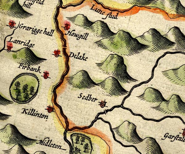 SP14SD69.jpg
 |
Clough River -- river -- SD7389 (etc etc)
-- double line, into the Rawthey
Dee, River -- river -- SD7186 (etc etc) ? -- double line, into the Lune Dillicar -- building/s (mostly gone) -- locality -- SD6197 -- 'Delake' -- circle, tower Firbank -- building/s -- SD626940 (etc) -- 'Firbank' -- circle, tower Howgill -- SD6396 (etc) -- 'Howgill' -- circle, tower Killington -- building/s -- SD6188 ? -- 'Killinton' -- circle, building and tower Lune, River -- river etc -- NY6205 (etc) -- 'Lune flud' -- double line; county boundary -- double line with stream lines Rawthey, River -- river -- SD6894 (etc etc) ? -- double line, into the Lune Sedbergh New Bridge (?) -- bridge -- SD66519194 ? -- double line across the Rawthey at Sedbergh Sedbergh -- building/s etc -- SD662921 -- 'Sedber' -- circle, building and tower | |
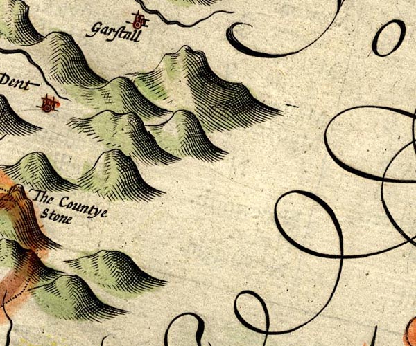
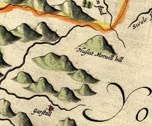 SP14SD79.jpg
 |
Garsdale -- building/s -- locality -- SD7489 ?
-- 'Garstall' -- circle, building and tower
Hugh Seat -- hill -- SD80919910 -- 'Huseat Morvell hill' -- hillock | |
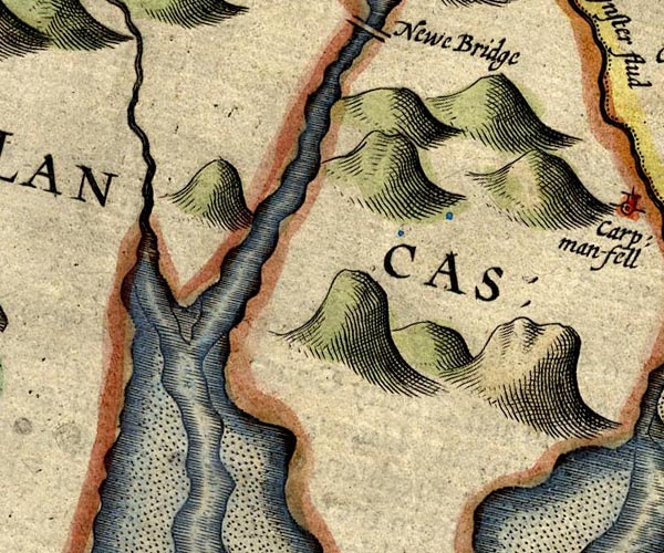 SP14SD38.jpg
 |
Crake, River -- river etc -- SD2987 (etc)
-- double line, into the Leven Estuary
Leven Estuary -- estuary -- river estuary -- sea area -- SD3375 (etc) -- estuary Leven, River -- river etc -- SD3483 (etc) ? -- estuary, into the sea | |
 SP14SD48.jpg
 |
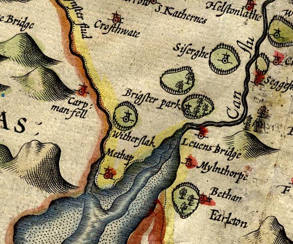
Beetham Park -- park -- SD4978
-- ring of fence palings, trees, at Beetham
Beetham -- building/s -- SD4979 -- 'Bethan' -- circle, building and tower Brigsteer Park -- park -- SD4888 -- ring of fence palings, trees, a park Brigsteer -- building/s -- SD480895 -- circle, tower, in the park perhaps Cartmel Fell -- building/s -- locality -- SD415880 (etc) ? -- 'Carp: man-fell' -- circle, tower Kent Estuary -- estuary -- river estuary -- sea area -- SD4377 (etc) -- estuary Kent, River -- river etc -- NY4506 (etc) -- 'Can flu' -- double line, and estuary Levens Bridge -- bridge -- SD49618522 -- 'Levens Bridge' -- circle, tower; no bridge marked Levens Park -- park -- SD5085 -- 'Brigster park' -- ring of fence palings, trees, a park, contains Brigsteer Meathop -- building/s -- SD4380 -- 'Methop' -- circle, building and tower Milnthorpe -- building/s etc -- SD496815 -- 'Mylnthorpe' -- circle, tower Sizergh Castle -- building/s -- park -- SD49868788 -- 'Siserghe' -- circle, tower and ring of fence palings for the park Winster, River -- river -- SD4285 (etc) -- 'Wynster flud' -- double line; county boundary -- double line, into the Kent Estuary; county boundary Witherslack Hall -- building/s -- park -- school -- SD43628617 -- ring of fence palings, contains Witherslack Witherslack -- building/s -- SD4383 -- 'Witherslack' -- circle, tower, in a park | |
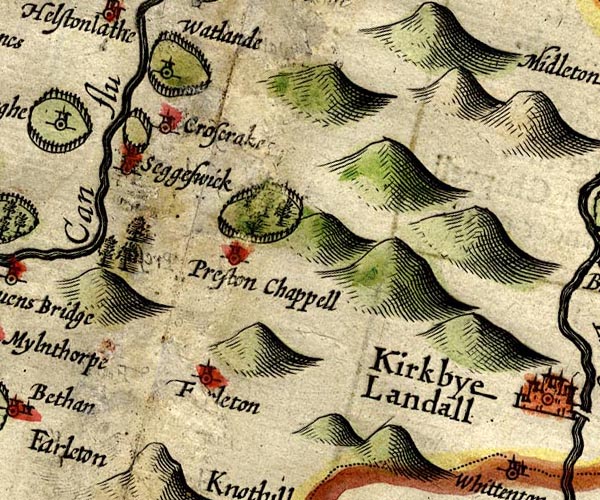 SP14SD58.jpg
 |
Crosscrake -- building/s -- SD524870
-- 'Croscrake' -- circle, tower
Farleton -- building/s -- SD535810 -- 'F[ r]leton' -- circle, tower Kent, River -- river etc -- NY4506 (etc) -- 'Can flu' -- double line, and estuary Natland Park -- building/s -- SD521897 -- ring of fence palings, a park, contains Natland Natland -- building/s -- SD5289 -- 'Watlande' -- circle, tower Old Hall -- building/s -- SD532844 ? -- ring of fence palings, by Preston Chapel possibly park, Sedgwick -- park -- SD5187 -- ring of fence palings, by Sedgwick possibly Sedgwick -- building/s -- SD5187 -- 'Seggeswick' -- circle, building and tower St Patrick's Church -- church -- SD53698351 -- 'Preston Chappell' -- circle, tower | |
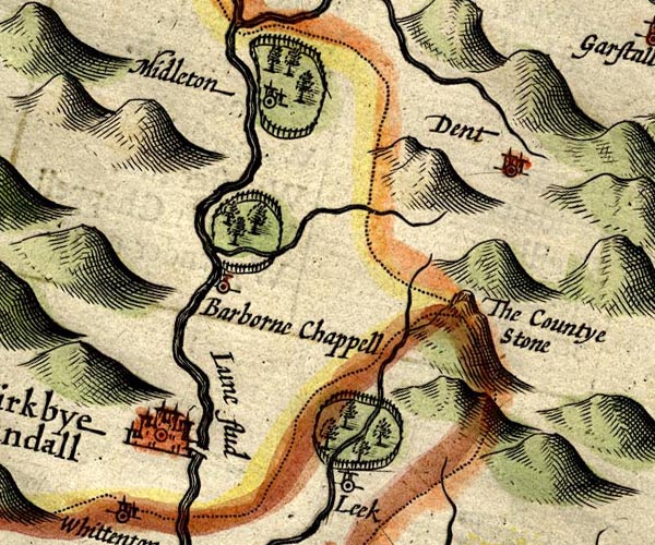 SP14SD68.jpg
 |
Barbon Beck -- river -- SD6482
-- double line, into the Lune
Barbon Park -- park -- SD6483 -- ring of fence palings, trees, by Barbon County Stone -- boundary stone -- stone -- county boundary mark -- SD70148274 -- 'The Countye Stone' -- on a hillock, at the meet of three counties Dent -- building/s -- SD705871 -- 'Dent' -- circle, towers Devil's Bridge -- bridge -- SD61557823 -- double line across the Lune Fairthwaite Park House -- building/s -- park -- SD638770 -- ring of fence palings, by Leck, Lancashire Kirkby Lonsdale -- building/s etc -- SD613783 -- 'Kirkbye Landall' -- circle, buildings and towers Leck -- building/s -- SD643767 ? -- 'Leek' -- circle, tower Lune, River -- river etc -- NY6205 (etc) -- 'Lune flud' -- double line; county boundary -- double line with stream lines Middleton Hall -- building/s -- park -- SD626875 -- ring of fence palings, trees, contains Middleton Middleton -- area -- SD6486 (etc) -- 'Midleton' -- circle, building and tower, in the park St Bartholomew's Church -- church -- SD63038246 -- 'Barborne Chappell' -- circle, tower | |
 SP14SD78.jpg
 | ||
 SP14SD37.jpg
 |
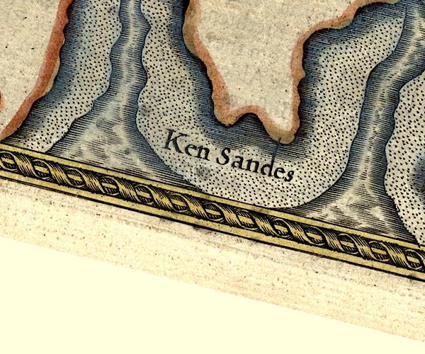
Lancaster Sands -- sands -- foreshore -- SD47 (etc)
-- 'Ken Sandes' -- sands -- sands
Leven Estuary -- estuary -- river estuary -- sea area -- SD3375 (etc) -- estuary Ulverston Sands -- sands -- SD3074 (etc) -- 'Ken Sandes' -- sands | |
 SP14SD47.jpg
 |
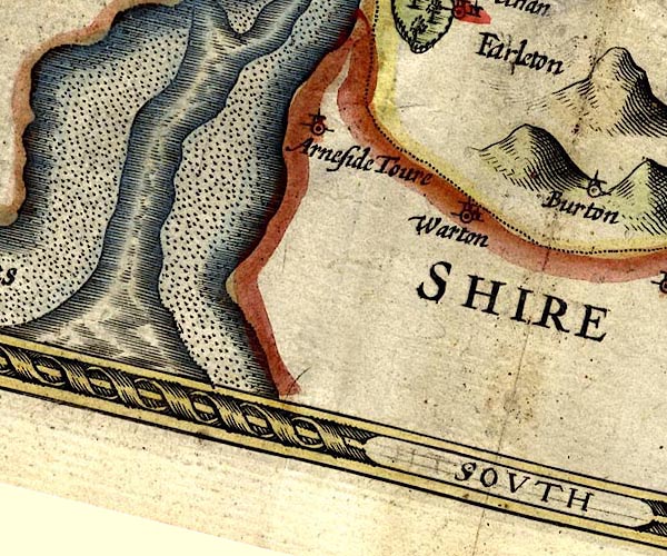
Arnside Tower -- tower -- castle -- pele tower --
SD458768
-- 'Arneside Tower' -- circle, tower
Kent Estuary -- estuary -- river estuary -- sea area -- SD4377 (etc) -- estuary Lancaster Sands -- sands -- foreshore -- SD47 (etc) -- 'Ken Sandes' -- sands -- sands Warton -- building/s -- SD5072 -- 'Warton' -- circle, building and tower | |
 SP14SD57.jpg
 |
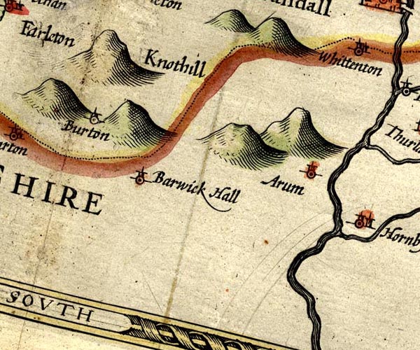
Arkholme -- building/s -- SD583722
-- 'Arum' -- circle, tower
Borwick Hall -- building/s -- SD527729 -- 'Barwick Hall' -- circle, tower Burton-in-Kendal -- building/s etc -- SD531765 -- 'Burton' -- circle, tower Farleton Knott -- rocks -- SD5480 -- 'Farleton Knothill' -- hillock | |
 SP14SD67.jpg
 |
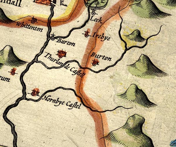
Burton in Lonsdale -- building/s -- SD652722
-- 'Burton' -- circle, tower, Lancashire
Doe, River -- river -- SD694732 (etc) -- double line, into the Greta Greta, River -- river -- SD599728 -- double line, into the Lune Hornby Castle -- castle -- SD587686 -- 'Hornbye Castell' -- circle, two towers Ireby -- building/s -- SD654755 -- 'Irebye' -- circle, tower Kingsdale Beck -- river -- SD6976 -- double line, into the Greta Leck Beck -- river -- SD610754 -- double line, into the Lune Thurland Castle -- castle -- SD610730 -- 'Thurlande Castell' -- circle, towers Wenning, River -- river -- SD571683 -- double line, into the Lune Whittington -- building/s -- SD600763 -- 'Whittenton' -- circle, building and tower | |
 Lakes Guides menu.