 Speed 1611
 |
 |
|
|
Places Identified
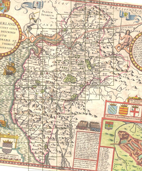
Map, hand coloured engraving, Cumberland and the Ancient Citie Carlile Described, scale about 4 miles to 1 inch, by John Speed, 1610, published by J Sudbury and George Humble, Popes Head Alley, London, 1611-12. NB: each image includes an overlap, places in the overlap are not listed. The images are roughly equivalent to ngr 10Km squares and are listed from top left to bottom right. | ||
 ScSP11Sq.jpg
 | ||
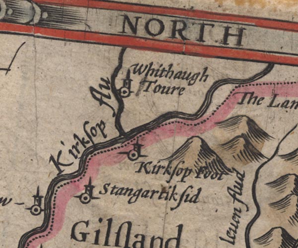 SP11NY48.jpg
 |
Harelaw -- building/s -- NY4378
-- 'Harelaw' -- circle, tower; Scotland
Kershope Burn -- river -- boundary -- NY5184 (etc etc) -- 'Kirksop flu' -- double line with stream lines; national boundary Kershopefoot -- building/s -- NY475829 (?) ? -- 'Kirksop foot' -- circle, tower Liddel Water -- river -- boundary -- national boundary -- county boundary -- NY4377 (etc) -- double line, joined by the Kershope -- double line with stream lines, runs into the Esk; national boundary Stonegarthside Hall -- building/s -- NY48038186 ? -- 'Stangartiksid' -- circle, tower Whithaugh Tower -- tower -- NY4988 -- 'Whithaugh Toure' -- circle, tower; Scotland | |
 SP11NY58.jpg
 |
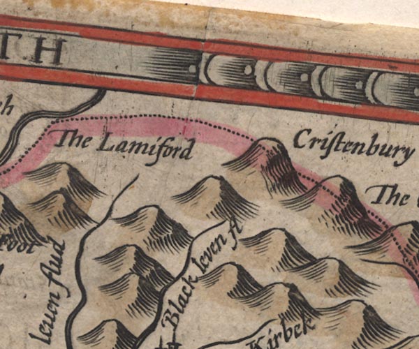
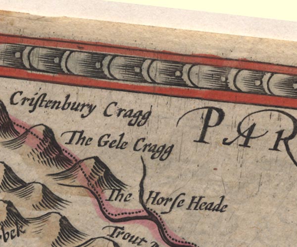
Christianbury Crag -- hill -- NY577822
-- 'Cristenbury Cragg' -- hillock; on the border
Lamiford -- NY58 -- 'The Lamiford' -- area on the border White Lyne -- river -- NY4973 (etc) -- 'Black leven flud' -- double line, runs into the Lyne | |
 SP11NY68.jpg
 |
Gill Pike -- hill -- NY614838 ?
-- 'The Gele Cragg' -- hillock; on the border
Horse Head -- hill -- NY617810 (?) -- 'The Horse Head' -- hillock; on the border Horsehead Grain -- river -- county boundary -- NY6180 (etc) -- wiggly line, runs into the Trout Beck/Gair Burn; county boundary | |
 SP11NY37.jpg
 |
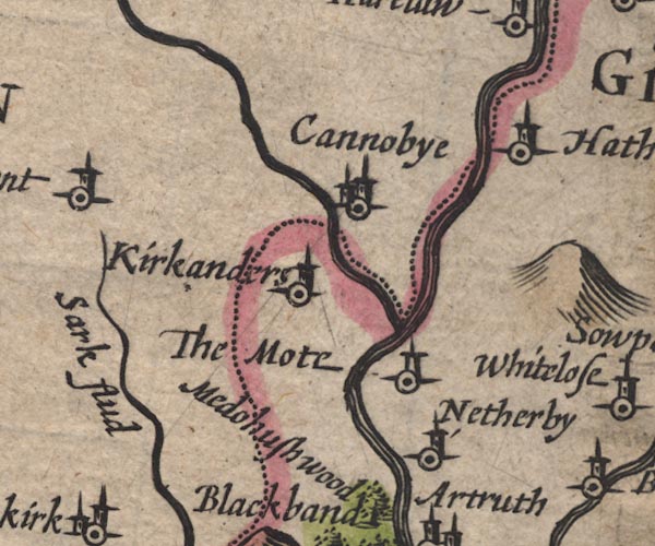
Canonbie -- building/s -- NY392764
-- 'Cannobye' -- circle, towers; in Scotland
Esk, River -- river -- boundary -- county boundary etc -- NY3666 (etc) -- 'Esk flud' -- double line; becomes the national boundary; labelled further NW -- estuary between foreshore sands, runs into the Eden Estuary Haithwaite -- building/s -- NY443773 ? -- 'Hathewate' -- circle, tower Kinmont (?) -- building/s -- NY37 -- 'Kinmont' -- circle, tower; in Scotland Kirkandrews -- locality -- NY3569 (etc) -- 'Kirkanders' -- circle, tower Liddel Strength -- earthwork -- castle -- motte and bailey -- NY40177416 ? -- 'The Mote' -- circle, tower Liddel Water -- river -- boundary -- national boundary -- county boundary -- NY4377 (etc) -- double line, joined by the Kershope -- double line with stream lines, runs into the Esk; national boundary Netherby -- building/s -- park -- NY39667161 -- 'Netherby' -- circle, tower Sark, River -- river -- boundary -- national boundary -- county boundary -- NY3372 (etc) -- 'Sark flud' -- double line -- estuary, runs into the Eden Estuary; Scotland | |
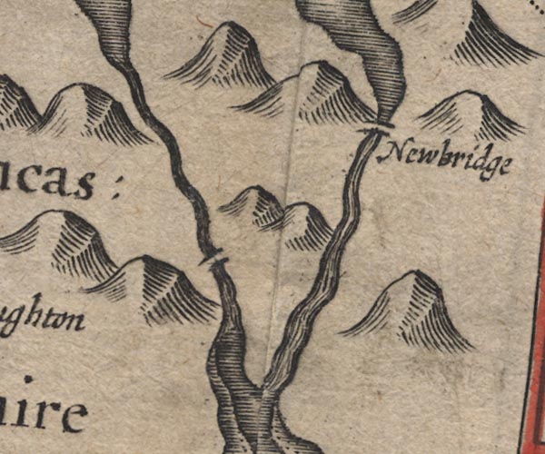
 SP11NY47.jpg
 |
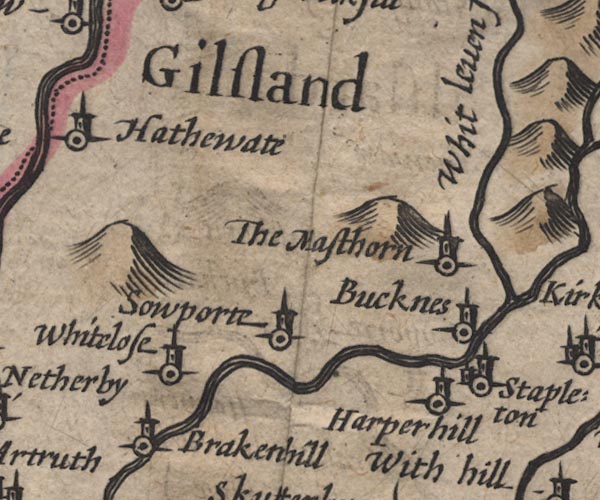
Black Lyne -- river -- NY5075
-- 'Whit leven flud' -- double line, runs into the Lyne
Brackenhill Tower -- tower -- NY445694 ? ? -- 'Brakenhill' -- circle, tower probably Gilsland -- locality -- NY47 (etc) -- 'Gilsland' -- area Harperhill -- building/s -- NY501716 -- 'Harperhill' -- circle, tower High Mossthorn -- building/s -- NY514734 ? ? -- 'The masthorn' -- circle, tower Low Luckens -- building/s -- NY493726 -- 'Bucknes' -- circle, tower Solport -- locality -- NY4773 (?etc) -- 'Sowporte' -- circle, tower Stapleton -- building/s -- NY505712 -- 'Stapleton' -- circle, building, tower Whiteclose -- building/s -- NY467709 -- 'Whitelose' -- circle, tower | |
 SP11NY57.jpg
 |
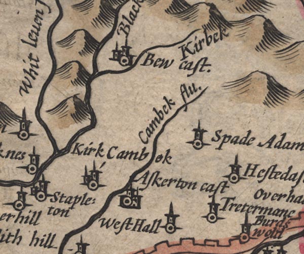
Askerton Castle -- castle -- pele tower (?) -- NY55036920
?
-- 'Askerton cast' -- circle, buildings, tower
Bew Castle -- castle -- NY56567468 -- 'Bew cast.' -- circle, buildings, tower Cam Beck -- river -- NY5469 (etc) -- 'Cambek flu.' -- double line -- double line with stream lines, runs into the Irthing Highstead Ash -- building/s -- NY599692 -- 'Hestedash' -- circle, tower Kirk Beck -- river -- NY5774 (etc) -- 'Kirbek' -- wiggly line, runs into the White Lyne Kirkcambeck -- building/s -- NY534689 -- 'Kirk Cambok' -- circle, building, tower Spadeadam -- building/s -- NY585706 -- 'Spade Adam' -- circle, tower Triermain -- building/s -- NY593667 -- 'Tretermane' -- circle, tower West Hall -- building/s -- NY566677 -- 'West Hall' -- circle, tower White Lyne -- river -- NY4973 (etc) -- 'Black leven flud' -- double line, runs into the Lyne | |
 SP11NY67.jpg
 |
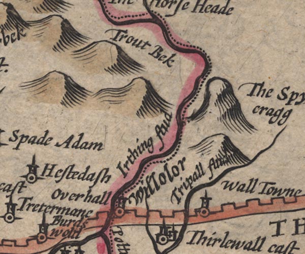
Gair Burn -- river -- boundary -- NY6278 (etc) ?
-- 'Trout Beck' -- double line with stream lines; county
boundary
Hadrian's Wall -- roman wall -- NY6166 (etc) -- crenellated wall, from Bowness-on-Solway, through Carlisle, north and east into Northumberland Irthing, River -- river -- boundary -- county boundary -- NY4758 (etc etc) -- 'Irthing flud' -- double line with stream lines; county boundary -- double line with stream lines, runs into the Eden Over Hall (?) -- building/s -- NY6367 (roughly) -- 'Overhall' -- circle, tower; Northumberland Spy Rigg -- hill -- NY688758 -- 'The Spye cragg' -- hillock; Northumberland Tipalt Burn -- river -- NY6963 -- 'Tripall flud' -- double line; Northumberland -- double line, runs into the South Tyne; Northumberland Walltown -- building/s -- NY679665 -- 'Wall Towne' -- circle, tower; Northumberland Willowford -- building/s -- NY629666 (?) -- 'Willolor' -- ?added by a different engraver? Northumberland perhaps | |
 SP11NY16.jpg
 |
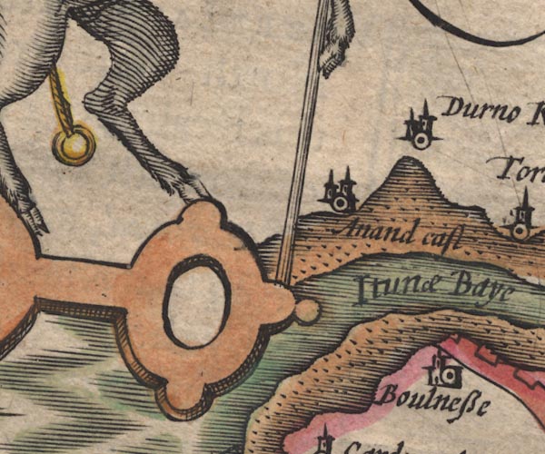
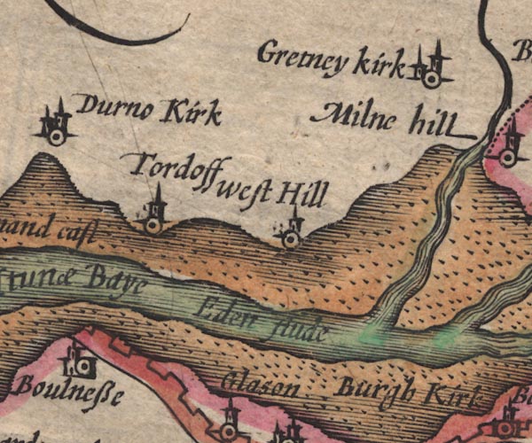
Annan Castle -- castle -- NY192666
-- 'Anand cast.' -- circle, towers; Scotland
Bowness-on-Solway -- building/s -- NY224628 -- 'Boulnesse' -- circle, building, tower Dornock -- building/s -- NY231660 -- 'Durno Kirk' -- circle, tower; Scotland Solway Firth -- estuary -- river estuary -- sea area -- NY16 (etc) ? -- 'Itunae Baye' -- estuary, river channel and foreshore sands | |
 SP11NY26.jpg
 |
Eden Estuary -- estuary -- river estuary -- NY1963
(etc)
-- 'Eden flude' -- river channel between foreshore sands
Gretna Green -- building/s -- NY319680 -- 'Gretney kirk' -- circle, building, tower; Scotland Sark, River -- river -- boundary -- national boundary -- county boundary -- NY3372 (etc) -- 'Sark flud' -- double line -- estuary, runs into the Eden Estuary; Scotland Torduff -- locality -- NY257646 -- 'Tordoff' -- circle, tower; Scotland Westhills -- building/s -- NY272654 -- 'West Hill' -- circle, tower; Scotland | |
 SP11NY36.jpg
 |
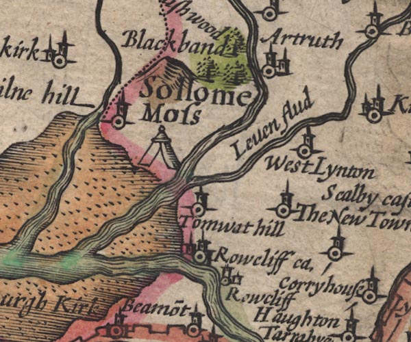
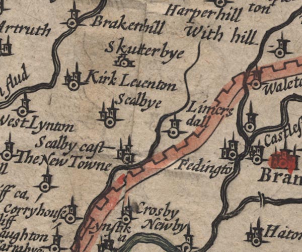
Arthuret -- locality -- NY46 (roughly) ?
-- 'Artruth' -- circle, building, tower
Battle of Solway Moss -- battle site -- NY3469 -- tent symbol on Solway Moss Blackbank -- building/s -- NY3467 -- 'Blackband' -- hillock Eden, River -- river -- NY3658 (etc) -- 'Eden flu' -- runs out to its estuary -- double line with stream lines -- double line with stream lines, then wiggly line; county boundary Esk, River -- river -- boundary -- county boundary etc -- NY3666 (etc) -- 'Esk flud' -- double line; becomes the national boundary; labelled further NW -- estuary between foreshore sands, runs into the Eden Estuary Lyne, River -- river etc -- NY3765 (etc) -- 'Leven flud' -- double line with stream lines, runs into the Esk Medohush Wood (?) -- wood -- forest -- NY3669 -- 'Medohush wood' -- group of trees Mill Hill -- building/s -- NY340679 -- 'Milne hill' -- circle, tower Newtown of Rockcliffe -- building/s -- NY389625 -- 'The New Towne' -- circle, tower Rockcliffe Castle -- castle (site) -- NY35356194 (?) -- 'Rowcliff ca.' -- circle, towers Rockcliffe -- building/s -- NY3561 -- 'Rowcliff' -- circle, building, tower Solway Moss -- moss -- peat moss -- NY3469 (etc) -- 'Sollome Moss' -- area Todhills -- building/s -- NY3663 ? -- 'Tomwat hill' -- circle, tower Westlinton -- building/s -- NY393645 -- 'West Lynton' -- circle, tower | |
 SP11NY46.jpg
 |
Cam Beck -- river -- NY5469 (etc)
-- 'Cambek flu.' -- double line -- double line with stream
lines, runs into the Irthing
Castlesteads -- building/s -- NY51246346 ? -- 'Castlestead' -- circle, tower -- circle, tower, N of river confluence Corryhouse (?) -- building/s (?) -- NY4061 (?) -- 'Corryhouse' -- circle, tower Crosby on Eden -- building/s -- NY465597 -- 'Crosby' -- circle, tower Gelt, River -- river -- NY5456 (etc) ? -- 'Gelt flud' -- double line with stream lines, runs into the Irthing -- wiggly line Hadrian's Wall -- roman wall -- NY6166 (etc) -- crenellated wall, from Bowness-on-Solway, through Carlisle, north and east into Northumberland Houghton -- building/s -- NY4059 -- 'Haughton' -- circle, tower; to disentangle the labels and symbols, use the pointer line Irthington -- building/s -- NY4961 -- 'Fedingto~' -- circle, building, tower Kirklinton -- building/s -- NY432670 -- 'Kirk Leventon' -- circle, building, tower Laversdale -- building/s -- NY475625 -- 'Limersdall' -- circle, tower Scaleby Castle -- castle -- NY44956251 -- 'Scalby cast.' -- circle, building, tower Scaleby -- building/s -- NY4463 -- 'Scalbye' -- circle, towers Skitby -- building/s -- NY44776565 -- 'Skutterbye' -- circle, buildings | |
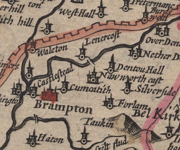 SP11NY56.jpg
 |
Birdoswald -- building/s -- NY6166
-- 'Burdswold' -- circle, tower
Brampton -- building/s etc -- NY530611 -- 'Brampton' -- circle, buildings, tower Castlesteads -- building/s -- NY51246346 ? -- 'Castlestead' -- circle, tower -- circle, tower, N of river confluence Cumcatch -- building/s -- NY54756115 -- 'Cumcatith' -- circle, tower Denton Hall -- building/s -- NY57836304 -- 'Dentou Hall' -- circle, tower Farlam -- building/s -- NY5558 -- 'Forlam' -- circle, tower Hadrian's Wall -- roman wall -- NY6166 (etc) -- crenellated wall, from Bowness-on-Solway, through Carlisle, north and east into Northumberland Lanercost Bridge -- bridge -- NY55346331 -- double line across the Irthing at Lanercost Lanercost -- building/s -- NY554638 -- 'Lenercost' -- circle, tower Low Gelt Bridge -- bridge -- NY51975916 -- double line across the Gelt, S of Brampton probably Naworth Castle (?) -- castle -- NY559625 ? -- 'Naworth cast' -- circle, building, tower Nether Denton -- locality -- NY5964 (?) -- 'Nether Denton' -- circle, building, tower Silver Side -- building/s -- NY577607 -- 'Silverside' -- circle, tower Walton -- building/s -- NY521644 -- 'Waleton' -- circle, tower White Hill -- building/s -- NY53696592 -- 'With hill' -- circle, tower | |
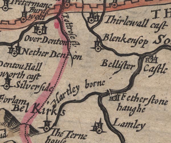 SP11NY66.jpg
 |
Bel Kirks -- area (?) -- NY6459 (?)
-- 'Bel Kirks' -- area on border; engraved by a different
hand?
Bellister Castle -- castle -- NY701629 -- 'Bellister Castle' -- circle, building, tower; Northumberland Blenkinsopp Hall -- building/s -- NY681641 ? -- 'Blenkensop' -- circle, tower; Northumberland bridge, Bridge End -- bridge -- NY675619 -- double line across the South Tyne at Faetherstonhaugh; Northumberland Featherstone -- locality -- NY6760 -- 'Fetherstone haugh' -- circle, building, tower; Northumberland Hartley Burn -- river -- NY6760 -- 'Hartley borne' -- double line, runs into the South Tyne; Northumberland Poltross Burn -- river -- boundary -- county boundary -- NY634664 -- 'Poltrose fl' -- wiggly line, runs into the Irthing; county boundary South Tyne, River -- river etc -- NY7441 (etc) ? -- 'South Tyne fl.' -- 'South Tyne' -- double line with stream lines -- double line with stream lines; Northumberland Tarn House -- building/s -- NY60585848 -- 'The Terne House' -- circle, tower; Northumberland Thirlwall Castle -- castle -- NY659661 -- 'Thirlewall cast' -- circle, building, tower; Northumberland Tipalt Burn -- river -- NY6963 -- 'Tripall flud' -- double line; Northumberland -- double line, runs into the South Tyne; Northumberland Upper Denton -- building/s -- NY616654 ? -- 'Over Denton' -- circle, towers | |
 SP11NY05.jpg
 | ||
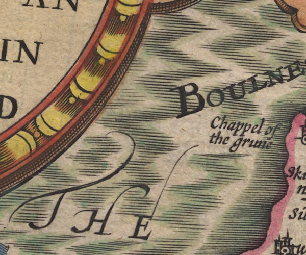
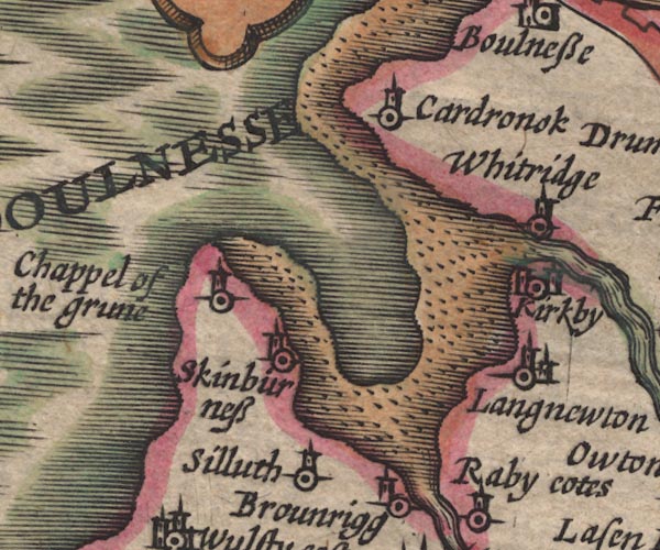 SP11NY15.jpg
 |
Bowness Point, Bowness -- headland, imagined -- NY1160
(?)
-- 'BOULNESSE' -- headland
Cardurnock -- building/s -- locality -- NY1758 -- 'Cardronok' -- circle, tower Chapel of the Grune -- chapel (gone) -- church (gone) -- NY13605644 (approx) -- 'Chappel of the grune' -- circle, tower Kirkbride -- building/s -- NY229568 -- 'Kirkby' -- circle, towers Moricambe -- bay -- foreshore -- NY1656 (etc) -- bay Newton Arlosh -- building/s -- NY1955 -- 'Langnewton' -- circle, building, tower Silloth -- building/s etc -- NY109536 -- 'Silluth' -- circle, tower; plotted too far inland Skinburness -- building/s etc -- NY125560 -- 'Skinburness' -- circle, tower Wampool, River -- river etc -- NY1757 (etc) ? -- 'Wampul flud' -- double line with stream lines, runs into the sea -- double line with stream lines Whitrigg Hall -- building/s -- NY22555786 (?) -- 'Whitridge' -- circle, tower | |
 SP11NY25.jpg
 |
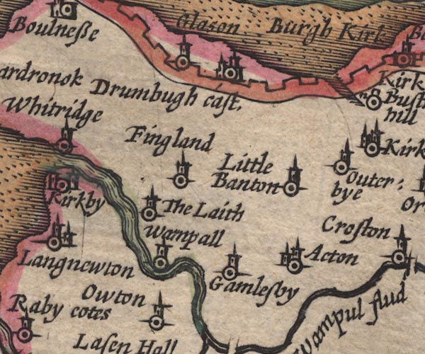
Aikton -- building/s -- NY2753
-- 'Acton' -- circle, building, tower
Drumburgh Castle -- castle -- NY265597 (?) -- 'Drumbugh cast.' -- circle, buildings, tower Fingland -- building/s -- NY25475711 -- 'Fingland' -- circle, tower Fresh Creek -- river -- parish boundary -- boundary -- NY2860 (etc) -- inlet through Hadrian's Wall near Bustwath hill Gamelsby -- building/s -- NY2552 -- 'Gamlesby' -- circle, tower Glasson -- building/s -- NY2560 -- 'Glasson' -- circle, tower Hadrian's Wall -- roman wall -- NY6166 (etc) -- crenellated wall, from Bowness-on-Solway, through Carlisle, north and east into Northumberland Laythes -- building/s -- NY2455 -- 'The Laith' -- circle, tower Little Bampton -- building/s -- NY2755 -- 'Little Banton' -- circle, tower Oughterby -- building/s -- NY2955 -- 'Outerbye' -- circle, tower Wampool -- building/s -- NY2454 -- 'Wampall' -- circle, tower Wampool, River -- river etc -- NY1757 (etc) ? -- 'Wampul flud' -- double line with stream lines, runs into the sea -- double line with stream lines | |
 SP11NY35.jpg
 |
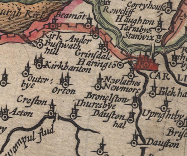
Beaumont -- building/s -- NY3459
-- 'Beamo~t' -- circle, tower
Blackhall -- locality -- NY4149 (about) -- 'Blek hal' -- circle, tower Boustead Hill -- building/s -- NY292589 -- 'Bustwath hill' -- circle, small building Brownelson -- building/s -- NY385522 -- 'Bronelston' -- circle, tower Burgh by Sands -- building/s -- NY323591 -- 'Burgh Kirk' -- circle, buildings, tower Caldew Bridge -- bridge -- NY395560 -- double line across the Caldew, E side of Carlisle Caldew, River -- river -- NY3851 (etc) ? -- 'Cauda flud' -- double line, runs into the Eden -- wiggly line Carlisle -- building/s etc -- NY403558 (etc) -- 'CARLILE' -- circle, buildings, towers Chalk Beck -- river -- parish boundary -- boundary -- NY3243 (etc) -- wiggly line, runs into the Wampool Crofton Bridge -- bridge -- NY308494 -- double line across the Wampool at Croston Crofton -- NY3050 -- 'Croston' -- circle, tower Dalston Hall -- building/s -- NY37655159 (etc) -- 'Dauston hal' -- circle, tower Eden Bridge -- bridge -- NY40075656 -- double line across the Eden, N side of Carlisle Great Orton -- building/s -- NY3254 -- 'Orton' -- circle, building, tower Grinsdale -- building/s -- NY3658 -- 'Grinsdale' -- circle, building, tower Hadrian's Wall -- roman wall -- NY6166 (etc) -- crenellated wall, from Bowness-on-Solway, through Carlisle, north and east into Northumberland Harrington (?) -- building/s -- locality -- NY3956 -- 'Haringto~' -- circle Kirkandrews upon Eden -- building/s -- NY3558 -- 'Kirk Ander' -- circle, building, tower Kirkbampton -- building/s -- NY3056 -- 'Kirkbanton' -- circle, building, tower Newby West -- building/s -- NY3653 ? ? -- 'Newmore' -- circle, tower Newlaiths Hall -- building/s -- NY385545 -- 'Newlaithes' -- circle, tower Thursby -- building/s -- NY3250 -- 'Thuresbye' -- circle, tower | |
 SP11NY45.jpg
 |
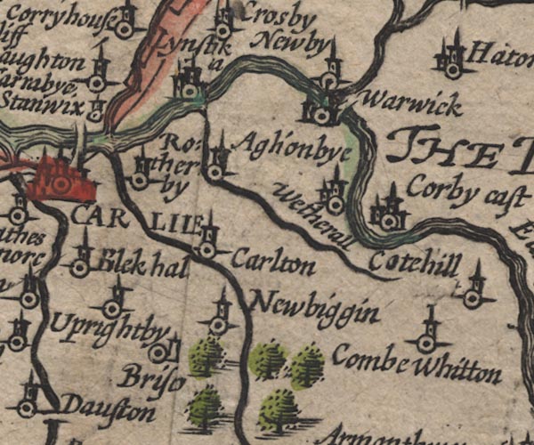
Aglionby -- building/s -- NY4456
-- 'Aglionbye' -- circle, tower
Botcherby -- building/s -- NY4155 -- 'Rotherby' -- circle, tower Brisco -- building/s -- locality -- NY410519 -- 'Briso' -- circle, small tower Brunstock Beck -- river -- NY4261 -- double line with stream lines, runs into the Eden Carleton -- building/s -- NY428528 -- 'Carlton' -- circle, tower Corby Castle -- castle -- garden -- NY4754 -- 'Corby cast' -- circle, buildings, tower Cumwhitton -- building/s -- NY5052 -- 'Combe Whitton' -- circle, tower Hadrian's Wall -- roman wall -- NY6166 (etc) -- crenellated wall, from Bowness-on-Solway, through Carlisle, north and east into Northumberland Inglewood Forest -- forest -- 'Inglewood Forest' -- group of trees, S of Newbiggin -- groups of tree symbols Irthing, River -- river -- boundary -- county boundary -- NY4758 (etc etc) -- 'Irthing flud' -- double line with stream lines; county boundary -- double line with stream lines, runs into the Eden Linstock Castle -- castle -- pele tower -- haunted house -- NY42895848 -- 'Lynstik [c]a' -- circle, buildings, tower Newbiggin House -- building/s -- NY433509 -- 'Newbiggin' -- circle, tower Newby East -- building/s -- NY475581 -- 'Newby' -- circle, tower Petteril, River -- river -- NY4935 (etc etc) -- 'Petterell flud' -- double line, runs into the Eden -- double line Pow Maughan -- river -- NY4552 (etc etc) -- wiggly line, runs into the Eden Stanwix -- building/s -- locality -- NY3957 -- 'Stanwix' -- circle, tower Tarraby -- building/s -- locality -- NY409581 -- 'Tarraby' -- circle, tower Upperby -- building/s -- NY4053 ? -- 'Uprightby' -- circle, tower Warwick -- building/s -- NY465566 -- 'Warwick' -- circle, building, tower Wetheral -- building/s -- NY4654 -- 'Wetherall' -- circle, building, tower | |
 SP11NY55.jpg
 |
Castle Carrock -- building/s -- NY5455
-- 'Castle Carok' -- circle, building, tower
Cotehill -- building/s -- NY468502 -- 'Cotehill' -- circle, tower Cumrew -- building/s -- NY5450 -- 'Cumrew' -- circle, building, tower Eden, River -- river -- NY3658 (etc) -- 'Eden flu' -- runs out to its estuary -- double line with stream lines -- double line with stream lines, then wiggly line; county boundary Gelt, River -- river -- NY5456 (etc) ? -- 'Gelt flud' -- double line with stream lines, runs into the Irthing -- wiggly line Hayton -- building/s -- NY507577 (etc) ? -- 'Haiton' -- circle, building, tower Talkin -- building/s -- NY549573 -- 'Taukin' -- circle, tower | |
 SP11NY65.jpg
 |
Ayle Burn -- river -- boundary -- county boundary --
NY7149
-- 'Alne fl' -- wiggly line, runs into the South Tyne;
county boundary -- wiggly line; county boundary
Gilderdale Burn -- river -- county boundary -- boundary -- NY704489 -- wiggly line, runs into the South Tyne; county boundary Kirkhaugh -- building/s -- NY6949 -- 'Kirk Haugh' -- circle, building, tower; Northumberland Knarsdale -- building/s -- NY677548 -- 'Knarsdale' -- circle, tower; Northumberland Lambley -- building/s -- NY6758 -- 'Lamley' -- circle, building, tower; Northumberland Whitley (?) -- locality -- NY6948 (approx) -- 'Whitlatton' -- circle, tower | |
 SP11NY04.jpg
 |
Allonby -- building/s -- NY0843
-- 'Allonbye' -- circle, tower
Dubmill -- locality -- NY078449 -- 'Dubmill' -- circle, tower Lowsay -- building/s -- NY11234844 ? -- 'The Lies' -- circle, tower Mawbray -- building/s -- NY0846 -- 'Old Mawboro' -- circle, tower | |
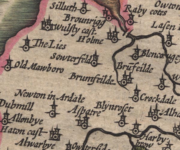 SP11NY14.jpg
 |
Abbey Town -- building/s etc -- NY175506
-- 'Holme' -- circle, building, tower
Aspatria -- building/s etc -- NY143418 -- 'Aspatre' -- circle, building, tower Blencogo -- building/s -- NY1947 -- 'Blenc[ou]gey' -- circle, tower Blennerhasset -- building/s -- NY1741 -- 'Blynroset' -- circle, tower bridge, Holme Abbey -- bridge -- NY184514 -- double line across the Waver at Holme Bromfield -- building/s -- NY1746 -- 'Bru~feilde / Brumfeilde' -- circle, building, tower; two labels, one place? Brownrigg -- building/s -- NY16885274 -- 'Brounrigg' -- circle, tower Crookdake -- building/s -- NY1943 -- 'Crockdale' -- circle, tower Crummock Beck -- river -- NY1846 (etc) ? ? -- double line, runs into the Waver Ireby Old Chancel -- church -- NY22383929 -- circle, tower; W of Ireby Raby Cote -- building/s -- NY17955238 -- 'Raby cotes' -- circle, tower Southerfield -- building/s -- NY1648 -- 'Sowterfeld' -- circle, tower Waver, River -- river etc -- NY1751 (etc) -- double line with stream lines, runs into Moricambe Bay Westnewton -- building/s -- NY136442 -- 'Newton in Ardale' -- circle, tower Wolsty Castle -- castle (ruin) -- NY10485060 -- 'Wulsty cast.' -- circle, buildings, towers | |
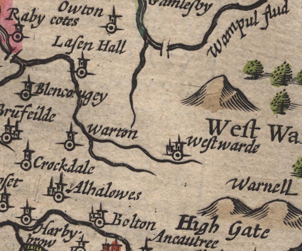 SP11NY24.jpg
 |
Allhallows -- locality -- NY1842
-- 'Alhalowes' -- circle, tower
Boltongate -- building/s -- NY229407 -- 'Bolton' -- circle, tower bridge, Woodside -- bridge -- NY279499 -- double line across the Wampool Lessonhall -- building/s -- NY22235018 -- 'Lasen Hall' -- circle, tower Little Waver -- river -- NY2343 (etc) -- wiggly line, runs into the Waver Oulton -- building/s -- NY248507 -- 'Owton' -- circle, tower Warnell Fell -- hill -- NY3341 -- Two hillocks by Warnell probably -- 'High Gate' -- label S of two hillocks; different engraver? probably Waverton -- building/s -- NY2247 ? ? -- 'Warton' -- circle, tower probably Westward -- building/s -- NY2744 -- 'Westwarde' -- circle, building, tower Wiza Beck -- river -- NY2745 (etc) -- wiggly line, runs into the Wampool | |
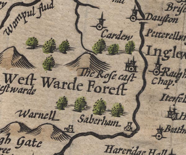 SP11NY34.jpg
 |
Cardew -- building/s -- NY3449
-- 'Cardew' -- circle, tower
Dalston Bridge -- bridge -- NY36964910 -- double line across the Caldew at Dalston Dalston -- building/s -- NY369501 -- 'Dauston' -- circle, tower Rose Castle -- bishop's palace -- palace -- castle -- NY37084616 -- 'The Rose cast' -- circle, buildings, tower Sebergham -- building/s -- NY357418 -- 'Saberham' -- circle, tower; different engraver for symbol? Warnell -- building/s -- NY3441 -- 'Warnell' -- circle, tower; different engraver for symbol? Westward Forest (?) -- forest -- NY34 (?) -- 'West Warde Forest' -- groups of tree symbols | |
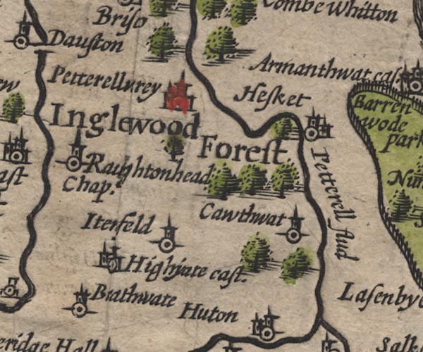 SP11NY44.jpg
 |
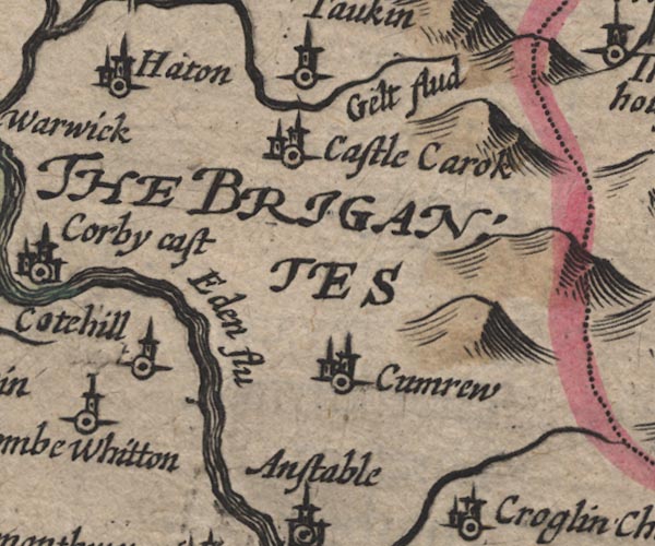
Braithwaite Hall -- building/s -- NY4141
-- 'Brathwate' -- circle, tower probably
Calthwaite -- building/s -- NY469401 -- 'Cawthwat' -- circle, tower High Head Castle -- castle (burnt out shell) -- NY40214339 ? ? -- 'Highyate cast.' -- circle, building, tower High Hesket -- building/s -- NY476445 ? -- 'Hesket' -- circle, building, tower Inglewood Forest -- forest -- 'Inglewood Forest' -- group of trees, S of Newbiggin -- groups of tree symbols Itonfield -- locality -- NY426432 ? -- 'Itenfeld' -- circle, tower Petteril, River -- river -- NY4935 (etc etc) -- 'Petterell flud' -- double line, runs into the Eden -- double line Raughton Head -- building/s -- NY3845 -- 'Raughtonhead Chap.' -- circle, tower Wreay -- building/s -- NY435489 -- 'Petterellwrey' -- circle, building, tower | |
 SP11NY54.jpg
 |
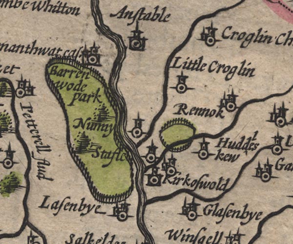
Ainstable -- building/s -- NY5346
-- 'Anstable' -- circle, building, tower
Armathwaite Place -- building/s -- pele tower -- castle (once) -- NY50584589 -- 'Armanthwat cas.' -- circle, buildings, tower Baronwood Park -- park -- NY5241 -- 'Barrenwode park' -- outline of fence palings, some trees Croglin Low Hall -- building/s -- NY55434502 ? ? -- 'Little Croglin' -- circle, tower probably Croglin Water -- river -- NY5746 (etc) -- wiggly line, runs into the Petteril Croglin -- building/s -- NY5747 -- 'Croglin Church' -- circle, building, tower Glassonby -- building/s -- NY576388 -- 'Glasenbye' -- circle, building, tower Hazelrigg Beck -- river -- NY6040 (etc) -- wiggly line, runs into the Petteril*RECORD_TYPE part record Huddlesceugh Hall -- building/s -- NY59764225 ? -- 'Huddleskew' -- circle, tower probably Kirkoswald Castle -- castle -- park (?) -- NY559410 -- circle, building, tower and ring of fence palings, N of Kirkoswald probably Kirkoswald -- building/s etc -- NY5541 -- circle, building, tower Lazonby -- building/s -- NY5439 -- 'Lasenbye' -- circle, building, tower Nunnery -- locality -- NY536428 (etc) -- 'Nunny' -- circle, tower Raven Beck -- river -- NY5942 (etc) -- wiggly line, runs into the Petteril Renwick -- building/s -- NY597435 -- 'Rennok' -- circle, tower Staffield -- building/s -- NY542428 -- 'Stafle' -- circle, tower | |
 SP11NY64.jpg
 |
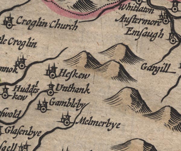
Gamblesby -- building/s -- NY609393
-- 'Gambleby' -- circle, building, tower
Haresceugh -- building/s -- NY609428 -- 'Heskew' -- circle, building, tower Melmerby -- building/s -- NY615373 -- 'Melmerbye' -- circle, building, tower Unthank -- building/s -- NY60974044 -- 'Unthank' -- circle, tower | |
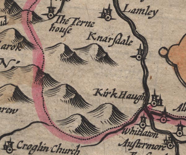
 SP11NY74.jpg
 |
Alston -- building/s etc -- NY719465
-- 'Austermore' -- circle, building, tower
Ash Gill -- river -- NY7540 (etc) -- wiggly line, runs into the South Tyne Ashgillside -- building/s -- NY7540 ? ? -- 'Esgill' -- circle, tower Black Burn -- river -- NY6841 -- wiggly line, runs into the South tyne Cross Gill -- river -- NY7440 (etc) -- wiggly line, runs into the South Tyne Garrigill -- building/s -- NY744415 ? -- 'Gargill' -- circle, building, tower Low Ameshaugh -- building/s -- NY711439 -- 'Emsaugh' -- circle, tower Low Houses -- building/s -- NY742420 ? ? ? -- 'The houses' -- circle, building, tower possibly Middle Houses -- building/s -- NY743421 ? ? ? -- 'The houses' -- circle, building, tower possibly Nent, River -- river -- NY7446 (etc etc) -- 'Vent flud' -- wiggly line, runs into the South Tyne Pennines, The -- hill -- NY55 -- hillocks -- hillocks; Westmorland South Tyne, River -- river etc -- NY7441 (etc) ? -- 'South Tyne fl.' -- 'South Tyne' -- double line with stream lines -- double line with stream lines; Northumberland | |
 SP11NY03.jpg
 |
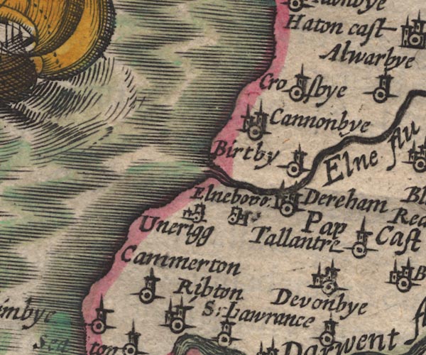
Birkby -- building/s -- NY0637
-- 'Birtby' -- circle, tower
Camerton -- building/s -- NY0330 ? -- 'Cammerton' -- circle, tower AND circle, building, tower Crosby -- building/s -- NY071384 ? -- 'Crosbye' -- circle, tower Crosscanonby -- building/s -- NY0738 ? -- 'Cannonbye' -- circle, building, tower Dearham -- building/s -- NY071360 -- 'Dereham' -- circle, building, tower Dovenby -- building/s -- NY0933 -- 'Devonbye' -- circle, building, tower Ellen, River -- river -- NY2436 (etc) -- 'Elne flu' -- double line with stream lines, runs into the sea Ellenborough -- building/s -- NY045358 -- 'Elneboro' -- circle, tower; different style of symbol Ewanrigg Hall -- building/s -- NY04443531 -- 'Unerigg' -- circle, tower; different style of symbol | |
 SP11NY13.jpg
 |
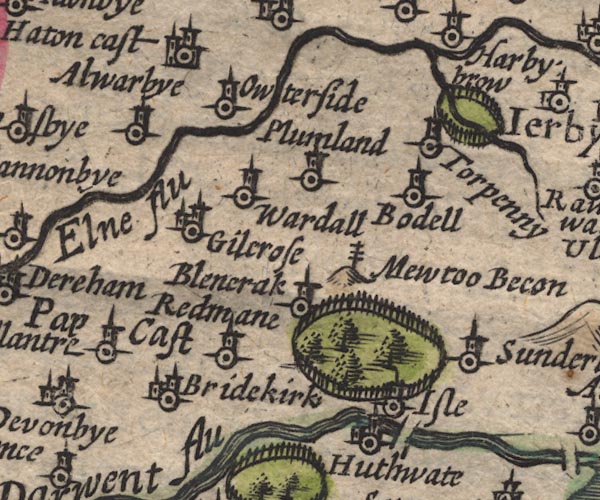
Allerby -- building/s -- NY0839
-- 'Alwarbye' -- circle, tower
Mewton Beacon -- beacon -- NY1436 -- 'Mewtoo Becon' -- post with cross rails on a hillock Blindcrake -- building/s -- NY1434 -- 'Blenerak' -- circle, tower Bothel -- building/s -- NY1838 -- 'Bodell' -- circle, tower Bridekirk -- building/s -- NY118336 -- 'Bridekirk' -- circle, building, tower Cockshot Beck -- river -- NY20704061 -- wiggly line, runs into the Ellen Gilcrux -- building/s -- NY1138 -- 'Gilcrose' -- circle, tower Hayton Castle -- castle -- NY11004175 -- 'Haton cast' -- circle, building, towers Hewthwaite Hall -- building/s -- NY15233283 -- 'Huthwate' -- circle, tower Isel Bridge -- bridge -- NY16413331 -- double line across the Derwent at Isel Isel Park -- park -- NY1534 -- ring of fence palings, some trees, N of Isel Isel -- locality -- NY167338 -- 'Isle' -- circle, tower Oughterside -- building/s -- NY1140 -- 'Owterside' -- circle, tower Papcastle -- building/s -- NY1031 -- 'Pap Cast' -- circle, tower park, Ireby -- park -- NY212402 -- ring of fence palings, NE of Torpenhow Plumbland -- building/s -- NY150391 (?etc) -- 'Plumland' -- circle, tower Redmain -- building/s -- NY13803387 -- 'Redmane' -- circle, tower Sunderland -- building/s -- NY1735 -- 'Sunderland' -- circle, tower Tallentire -- building/s -- NY108354 -- 'Tallantre' -- circle, tower Torpenhow -- building/s -- NY2039 -- 'Torpenny' -- circle, tower Wardhall Guards -- building/s -- NY13313861 -- 'Wardall' -- circle, tower | |
 SP11NY23.jpg
 |
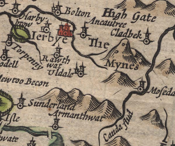
Armathwaite Hall -- building/s -- hotel -- NY207325
-- 'Armanthwat' -- circle, tower
Aughertree -- building/s -- NY2538 -- 'Ancautree' -- circle, tower Caldew, River -- river -- NY3851 (etc) ? -- 'Cauda flud' -- double line, runs into the Eden -- wiggly line Harbybrow -- building/s -- NY19214152 -- 'Harbybrow' -- circle, building, tower, N of the river confluence Ireby -- building/s etc -- NY238388 -- 'Ierbye' -- circle, buildings, towers Mosedale -- building/s -- NY356322 (etc) ? -- 'Mosedale' -- circle, tower Roughtongill Mines -- copper mine -- lead mine -- mine -- zinc mine -- mine -- NY298339 & NY309345 -- 'The Mynes' -- two ?adits on a hillock Ruthwaite -- building/s -- NY23783677 -- 'Rawthwat' -- circle, tower Uldale -- building/s -- NY2436 -- 'Uldale' -- circle, tower | |
 SP11NY33.jpg
 |
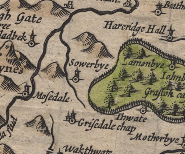
Caldbeck -- building/s -- NY323397
-- 'Cladbeck' -- circle, tower
Castle Sowerby -- locality -- NY3739 (etc) -- 'Sowerbye' -- circle, tower Gillcambon Beck -- river -- NY3835 (etc) -- wiggly line ruins into the Caldew Greenthwaite Hall -- building/s -- NY43153021 -- 'Thwate' -- circle, tower Greystoke Castle -- castle -- park -- haunted house -- pele tower (?) -- NY43543089 -- 'Grastok cast.' -- circle, buildings, tower; outline of fence palings, trees St Kentigern's Church -- church -- NY36353043 -- 'Grisedale chap' -- circle, building, tower | |
 SP11NY43.jpg
 |
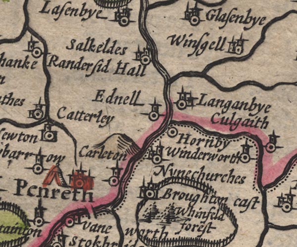
Catterlen -- building/s -- NY4833
-- 'Catterly' -- circle, tower
Ellonby -- building/s -- NY425354 -- 'Alonby' -- circle, tower Greystoke Castle -- castle -- park -- haunted house -- pele tower (?) -- NY43543089 -- 'Grastok cast.' -- circle, buildings, tower; outline of fence palings, trees Hardrigg Hall -- building/s -- NY42483618 -- 'Hareridge Hall' -- circle, tower Hutton-in-the-Forest -- building/s -- garden (?) -- NY460358 -- 'Huton' -- circle, building, tower Johnby -- building/s -- NY432331 -- 'Johnbye' -- circle, tower Laithes -- building/s -- NY464329 -- 'Lathes' -- circle, tower Lamonby -- building/s -- NY409358 -- 'Lamonbye' -- circle, tower Newbiggin -- building/s -- NY4629 -- 'Newbiggin' -- circle, tower Newton Reigny -- building/s -- NY4731 -- 'Newton' -- circle, tower Old Petterill -- river -- NY48983692 -- wiggly line, runs into the Petteril Randerside Hall (?) -- building/s -- NY4836 ? -- 'Randersid Hall' -- circle, tower probably Sewborwens -- building/s -- NY491302 -- 'Sawbarrow' -- circle, tower Skelton -- building/s -- NY437354 -- 'Skelton' -- circle, building, tower Stainton -- building/s -- NY4827 -- 'Stainton' -- circle, tower Unthank -- building/s -- NY452362 -- 'Unthanke' -- circle, tower | |
 SP11NY53.jpg
 |
battle site, Penrith -- battle site -- NY5130 (??)
-- tent, W side of Penrith
Briggle Beck -- river -- NY5833 (etc) -- wiggly line, runs into the Robberby Water Brougham Castle -- castle -- NY537290 -- 'Broughton cast' -- circle, buildings, tower; Westmorland Carleton -- building/s -- NY5329 -- 'Carleton' -- circle, tower Eamont Bridge bridge -- bridge -- NY52202875 -- double line across the Eamont, S of Penrith Eamont, River -- river -- NY469243 (from) ? ? -- double line with stream lines, runs into the Eden; county boundary -- double line; county boundary Eden, River -- river -- NY3658 (etc) -- 'Eden flu' -- runs out to its estuary -- double line with stream lines -- double line with stream lines, then wiggly line; county boundary Edenhall -- building/s -- NY565324 -- 'Ednell' -- circle, tower Great Salkeld -- building/s -- NY5536 -- 'Salkeldes' -- circle, building, tower Hornby Hall -- building/s -- NY56952995 ? ? -- 'Hornby' -- circle; Westmorland Langwathby -- building/s -- NY5633 -- 'Langanbye' -- circle, building, tower Little Salkeld -- building/s -- NY566361 -- 'Salkeldes' -- circle, building, tower Lowther, River -- river etc -- NY5124 (etc) -- wiggly line, runs into the Eamont; Westmorland Penrith -- building/s etc -- NY513304 -- 'Penreth' -- circle, buildings, towers Robberby Water -- river -- NY561359 -- wiggly line, runs into the Eden St Ninian's Church -- church -- NY55932995 -- 'Ninechurches' -- circle, building, tower; Westmorland Thacka Beck -- river -- NY49173297 -- wiggly line, runs into the Petteril Whinfell Forest -- forest -- wood -- NY5727 (etc) -- 'Whinfeld forest' -- tree symbols; Westmorland Whinfell Park -- building/s -- NY5528 -- outline of fence palings, contains Whinfeld forest; Westmorland Winderwath -- locality -- NY6510 (?) -- 'Winderworth' -- circle, tower; Westmorland Winskill -- building/s -- NY580349 -- 'Winsgell' -- circle, building, tower Yanwath -- building/s -- NY5127 -- 'Vaneworth' -- circle, tower; Westmorland | |
 SP11NY63.jpg
 |
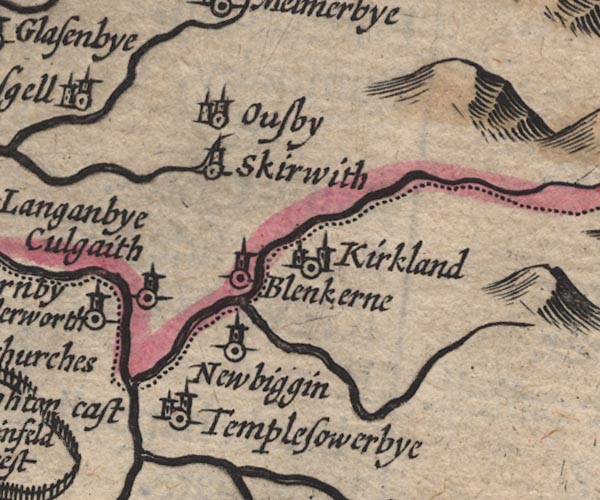
Blencarn -- building/s -- NY6331
-- 'Blenkerne' -- circle, tower
Crowdundle Beck -- river -- boundary -- parish boundary -- county boundary (once) -- NY6228 (etc) -- wiggly line, runs into the Eden; county boundary Culgaith -- building/s -- NY6129 -- 'Culgaith' -- circle, tower Kirkland -- building/s -- NY646325 -- 'Kirkland' -- circle, towers; Westmorland Milburn Beck -- river -- NY6528 (etc) -- wiggly line, runs into the Crowdundle Newbiggin -- building/s -- NY628285 -- 'Newbiggin' -- circle, tower; Westmorland Ousby -- building/s -- NY621348 -- 'Ousby' -- circle, building, tower Skirwith -- building/s -- NY6132 -- 'Skirwith' -- circle, tower Temple Sowerby -- building/s -- NY611271 -- 'Templesowerbye' -- circle, building, tower; Westmorland | |
 SP11NX92.jpg
 |
Irish Sea -- sea area -- NY04 & NY03 & NX93 &
NX92 & NX91 & NX90 & NY00 & SD09 & SD08
& SD18 & SD17 & SD16 & SD26 & SD36
-- 'THE IRISH SEA' -- sea moire effect, swash lettering
| |
 SP11NY02.jpg
 |
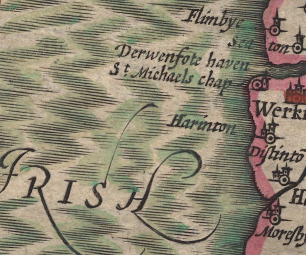
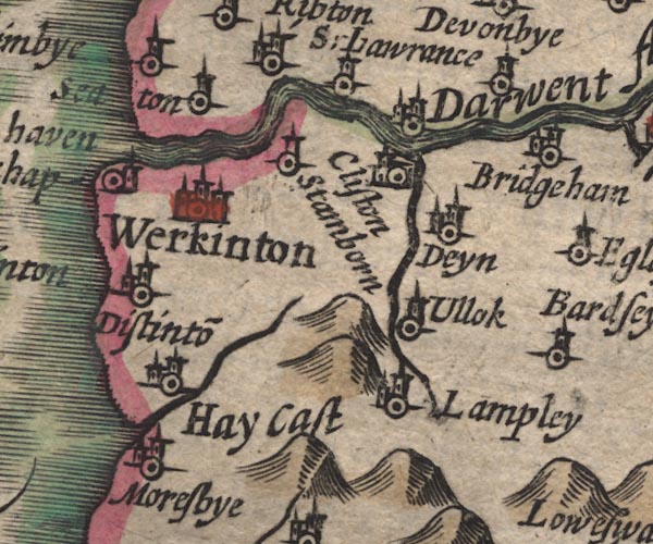
Dean -- building/s -- NY074253
-- 'Deyn' -- circle, tower
Derwenfoot Haven -- river mouth -- NX9829 -- 'Derwenfote haven' -- at the mouth of the Derwent Derwent, River -- river -- NY2515 (etc) ? -- 'Darwent flu' -- 'Darwen flu' -- double line with stream lines, runs into the sea -- between Derwent Water and Bassenthwaite Lake -- double line, runs into Derwent Water Distington -- building/s -- NY0023 -- 'Distinto~' -- circle, building, tower Flimby -- building/s -- NY0233 ? -- 'Flimbye' -- circle, tower Great Clifton -- building/s -- NY040297 ? ? -- 'Cliston' -- circle, building, tower Hayes Castle -- castle (ruins) -- NY00112258 ? -- 'Hay Cast' -- circle, building, tower Lamplugh -- building/s -- NY088207 -- 'Lampley' -- circle, building, tower Little Broughton -- building/s -- NY0731 -- circle, tower; across the Derwent from Brigham Lowca Beck -- river -- NX978212 -- wiggly line, runs into the sea Marron, River -- river -- NY0624 -- wiggly line, runs into the Derwent Moresby -- building/s -- NX9921 -- 'Moresbye' -- circle, building, tower Ribton Hall -- building/s -- NY04763053 ? -- 'Ribton' -- circle, building, tower AND circle, tower Seaton -- building/s etc -- NY0130 -- 'Seaton' -- circle, tower St Lawrence Chapel -- church -- chapel -- NY060304 -- 'S. Lawrance' -- circle, tower AND circle, building, tower; at confluence of Marron and Derwent St Michael's Chapel -- chapel -- NX986283 ? -- 'St. Michaels chap' -- circle, tower Stainburn -- building/s -- NY0229 ? -- 'Stainborn' -- circle, tower Ullock -- building/s -- NY0723 -- 'Ullock' -- circle, tower Workington -- building/s etc -- NX996288 -- 'Werkinton' -- circle, buildings, towers | |
 SP11NY12.jpg
 |
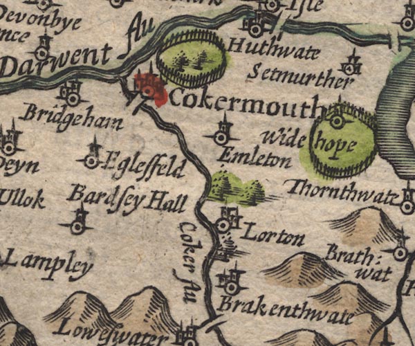
Brackenthwaite -- building/s -- NY154221
-- 'Brakenthwate' -- circle, building, tower
Brigham -- building/s -- NY0830 -- 'Bridgeham' -- circle, building, tower Cocker Bridge -- bridge -- NY12233071 -- double line across the Cocker Cocker, River -- river -- NY1426 ? -- 'Coker flu' -- double line with stream lines, runs into the Derwent Cockermouth -- building/s etc -- NY122306 -- 'Cokermouth' -- circle, buildings, towers Eaglesfield -- building/s -- NY093282 (etc) -- 'Eglesfeld' -- circle, tower Embleton -- building/s -- NY1730 -- 'Emleton' -- circle, tower High Lorton -- building/s -- NY162257 ? -- 'Lorton' -- circle, building, tower Pardshaw Hall -- building/s -- NY10272536 ? -- 'Bardsey Hall' -- circle, tower park, Cockermouth -- park -- NY1331 -- ring of fence palings, NE of Cockermouth Wythop Hall -- building/s -- park -- castle (perhaps) -- NY20312844 -- 'Widehope' -- circle, tower, in a ring of fence palings | |
 SP11NY22.jpg
 |
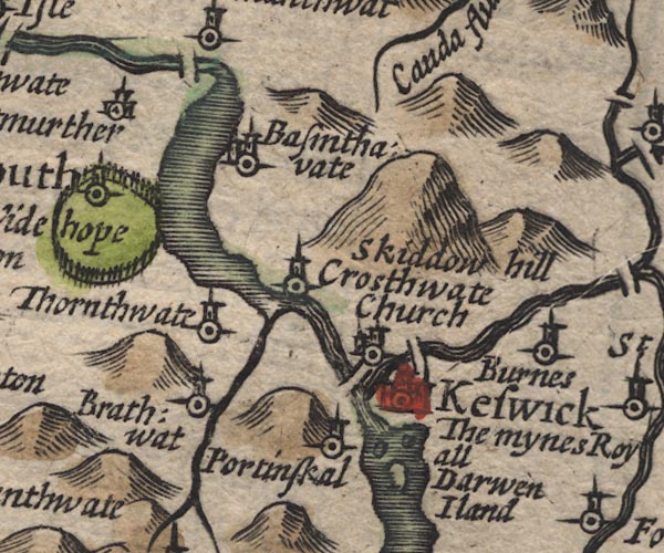
Bassenthwaite Lake -- lake -- NY215298
-- outline, shaded
Bassenthwaite -- building/s -- NY2332 -- 'Basinthavate' -- circle, building, tower Braithwaite -- building/s -- NY231235 -- 'Brathwat' -- circle, tower Burns Farm -- building/s -- NY30772424 -- 'Burnes' -- circle, tower Derwent Isle -- island -- NY261224 -- 'Darwen Iland' -- island in Derwent Water Derwent Water -- lake etc -- NY260210 ? -- outline, shaded, with 3 islands Derwent, River -- river -- NY2515 (etc) ? -- 'Darwent flu' -- 'Darwen flu' -- double line with stream lines, runs into the sea -- between Derwent Water and Bassenthwaite Lake -- double line, runs into Derwent Water Greta Bridge -- bridge -- NY26302374 ? ? -- double line across the Greta probably Greta, River -- river -- NY2924 -- double line with stream lines, runs into the Derwent Keswick Smelting House -- smelting house -- mine (associated) -- NY280238 (approx) -- 'The mynes Royall' -- by Keswick or Derwent Island Keswick -- building/s etc -- NY266234 -- 'Keswick' -- circle, buildings, towers Little Crosthwaite -- building/s -- NY234276 -- circle, tower; where the Newlands Beck and Derwent meet Bassenthwaite Lake Long Bridge -- footbridge -- bridge -- NY25362377 -- double line across the Derwent Newlands Beck -- river -- NY2319 -- wiggly line, runs into the Derwent Ouse Bridge -- bridge -- NY19963209 -- double line across the Derwent Portinscale -- building/s -- NY251235 -- 'Portinskal' -- circle, tower Setmurthy -- locality -- NY1832 -- 'Setmurther' -- circle, building, tower Skiddaw -- hill -- NY260290 -- 'Skiddow hill' -- a larger hillock St Kentigern's Church -- church -- NY25652431 -- 'Crosthwaite Church' -- circle, building, tower Thornthwaite -- building/s -- NY223254 ? -- 'Thornthwate' -- circle, tower | |
 SP11NY32.jpg
 |
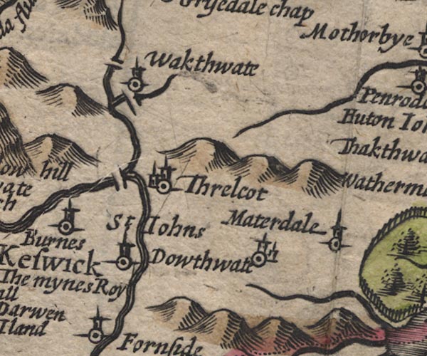
Dowthwaitehead -- building/s -- NY370208 ?
-- 'Dowthwate' -- circle, building, tower
ford, Wallthwaite -- ford -- NY35322620 (?) ? ? -- double line across Mosedale Beck possibly Glenderamackin, River -- river -- NY3426 -- double line, runs into the Greta Lamb Bridge -- bridge -- NY35372676 -- double line across the Glenderamackin Matterdale -- locality -- NY3922 (?) -- 'Materdale' -- circle, tower Mosedale Beck -- river -- NY3523 -- wiggly line, runs into the Glenderamackin St John's Beck -- river -- NY3123 ? -- double line, runs into the Great St John's in the Vale -- valley -- NY3122 (etc) -- 'St. Johns' -- circle, tower Threlkeld Bridge -- bridge -- NY31472470 -- double line across the Greta Threlkeld -- building/s -- NY322254 -- 'Threlcot' -- circle, building, tower Wallthwaite -- building/s -- NY35402624 -- 'Wakthwate' -- circle, tower | |
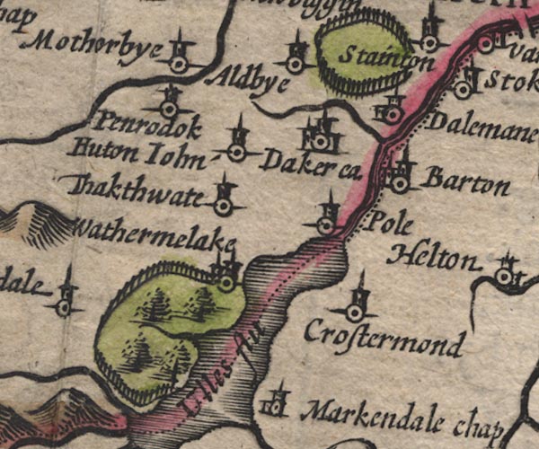 SP11NY42.jpg
 |
Aira Beck -- river -- NY40001974
-- wiggly line, runs into Ullswater
Aldby -- building/s -- NY46242774 -- 'Aldbye' -- circle, tower Barton -- building/s -- NY486264 -- 'Barton' -- circle, building, tower; Westmorland Cross Dormont -- building/s -- NY46182250 -- 'Crostermond' -- circle, tower; Westmorland Dacre Beck -- river -- NY4626 -- wiggly line runs into the Eamont Dacre Castle -- castle -- haunted house -- NY46052650 -- 'Dacre ca.' -- circle, buildings, tower Dalemain -- park -- building/s -- museum -- garden -- NY479269 -- 'Dalemane' -- circle, building, tower and ring of fence palings, W of Stainton Eamont, River -- river -- NY469243 (from) ? ? -- double line with stream lines, runs into the Eden; county boundary -- double line; county boundary Gowbarrow Park -- park -- NY408212 (etc) -- ring of fence palings, trees Hutton John -- park -- building/s -- tower -- pele tower -- NY43972696 -- 'Huton John' -- circle, tower Motherby -- building/s -- NY4228 -- 'Motherbye' -- circle, tower Parkhouse Gill -- river -- NY42592068 ? ? -- wiggly line, runs into Ullswater Penruddock -- building/s -- NY429276 -- 'Penrodok' -- circle, tower Pooley Bridge -- building/s etc -- NY472244 -- 'Pole' -- circle, tower; on the wrong side of the river Thackthwaite -- building/s -- NY423254 -- 'Thakthwate' -- circle, tower Ullswater -- lake -- NY422202 (etc) ? -- 'Ulles flu' -- outline, shore shaded; county boundary through the lake Watermillock -- building/s -- NY445224 -- 'Wathermelake' -- circle, buildings, tower | |
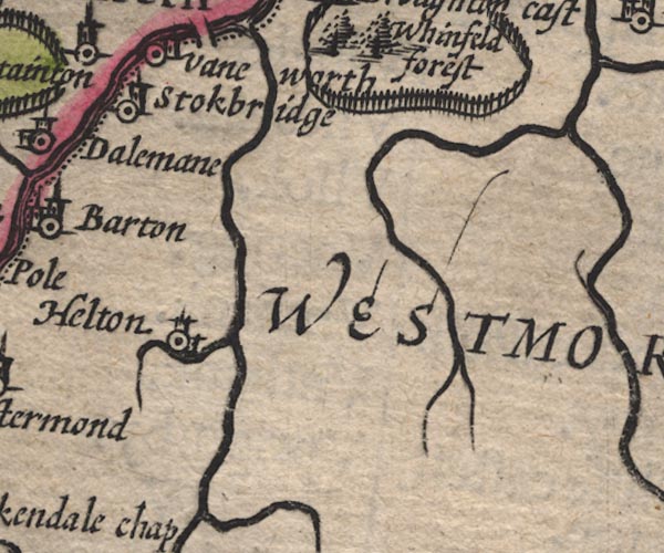 SP11NY52.jpg
 |
Helton -- building/s -- NY510220
-- 'Helton' -- circle, tower; Westmorland
Heltondale Beck -- river -- NY51522025 -- wiggly line, runs into the Lowther; Westmorland Sockbridge -- building/s -- NY500267 -- 'Stokbridge' -- circle, tower; Westmorland | |
 SP11NX91.jpg
 |
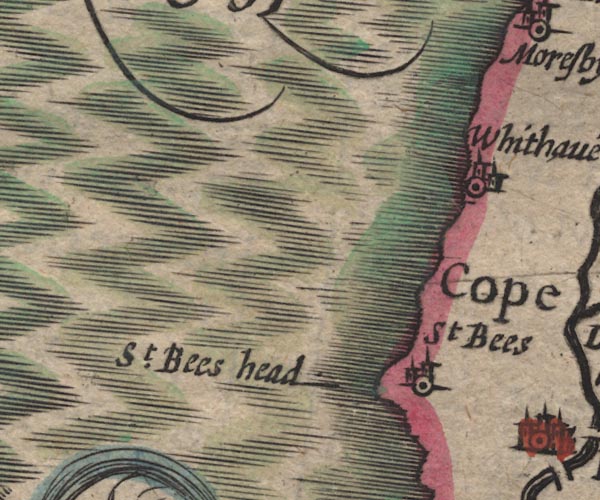
St Bees Head -- headland -- NX940143 (etc)
-- 'St. Bees head' -- headland
St Bees -- building/s -- NX971116 -- 'St Bees' -- circle, building, tower Whitehaven -- building/s etc -- NX974182 -- 'Whithave~' -- circle, building, tower | |
 SP11NY01.jpg
 |
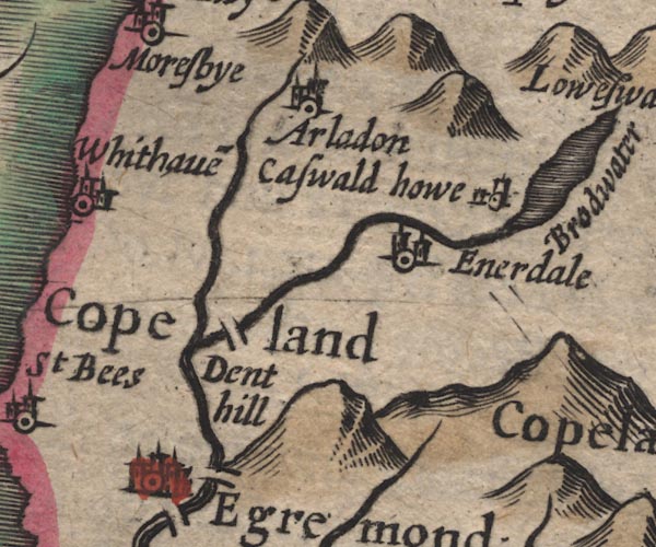
Arlecdon -- building/s -- NY049193
-- 'Arladon' -- circle, building, tower
Briscoemill Bridge -- bridge -- NY01511158 ? ? -- double line across the Ehen at Egremont perhaps Dent -- hill -- NY041128 -- 'Dent hill' -- hillock Egremont -- building/s etc -- NY011105 -- 'Egremond' -- circle, buildings, towers Ennerdale Bridge -- building/s -- NY069159 -- 'Enerdale' -- circle, building, tower How Hall Farm -- building/s -- NY09021635 -- 'Caswald howe' -- circle, tower; badly engraved symbol Keekle, River -- river -- NY0019 (etc) -- wiggly line, runs into the Ehen Wath Bridge -- bridge -- NY03171445 -- double line across the Ehen probably | |
 SP11NY11.jpg
 |
Bleaberry Tarn -- lake -- NY165154 ? ?
-- outline, shaded, oversize probably
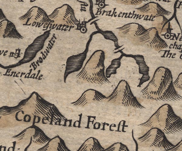
Buttermere -- lake -- NY182158 -- outline, shaded Copeland Forest -- forest -- NY10 (etc) -- 'Copeland Forest' -- area Crummock Water -- lake -- NY158189 -- outline, shaded Ennerdale Water -- lake -- NY106150 -- 'Brodwater' -- outline, shaded Loweswater -- lake -- NY125217 -- outline, shaded Loweswater -- building/s -- NY139208 -- 'Loweswater' -- circle, building, tower Scale Bridge -- bridge -- NY16791659 ? -- double line across Buttermere Dubs perhaps Scalehill Bridge -- bridge -- NY148215 -- double line across the Cocker at Loweswater | |
 SP11NY21.jpg
 |
Armboth -- locality -- NY305171
-- 'Armebath' -- circle, tower
Borrowdale -- locality -- valley -- NY257148 (etc etc) -- 'Borrodale' -- circle, tower Derwent Water -- lake etc -- NY260210 ? -- outline, shaded, with 3 islands Derwent, River -- river -- NY2515 (etc) ? -- 'Darwent flu' -- 'Darwen flu' -- double line with stream lines, runs into the sea -- between Derwent Water and Bassenthwaite Lake -- double line, runs into Derwent Water Grange -- building/s -- NY252174 -- 'The Grange' -- circle, tower Keskadale Beck -- river -- NY2119 ? -- wiggly line, runs into Newlands Beck Newlands Church -- chapel -- church -- school (ex) -- NY22981934 -- 'Newland chap.' -- circle, tower Stonethwaite Beck -- river -- NY2614 -- wiggly line, runs into the Derwent Watendlath -- building/s -- NY276163 -- 'Watenlath' -- circle, tower | |
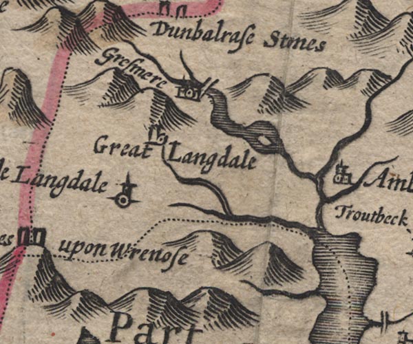
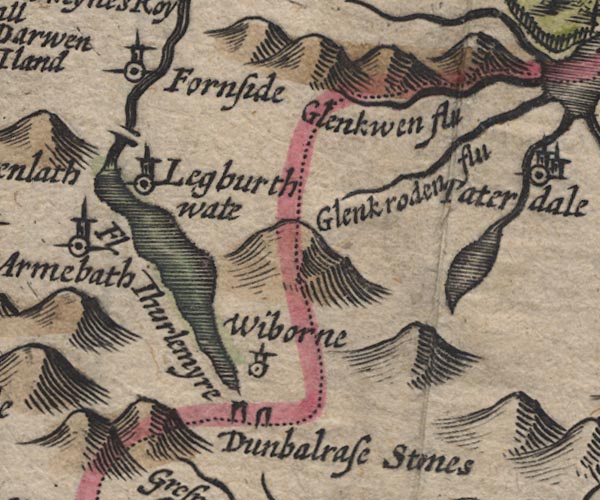 SP11NY31.jpg
 |
Dunmail Raise Stones -- cairn -- NY32721167
-- 'Dunbalrase Stones' -- two standing stones on the county
boundary
Fornside -- building/s -- NY32092062 -- 'Fornside' -- circle, tower Glencoyne Beck -- river -- boundary -- county boundary -- NY38751881 ? -- 'Glenkwen flu' -- wiggly line; county boundary Glenridding Beck -- river -- NY35971603 ? -- 'Glenkrodn flu' -- wiggly line; Westmorland Grisedale Tarn -- lake -- NY348120 ? -- outline, shaded; Westmorland Legburthwaite -- building/s -- NY319193 -- 'Legburthwate' -- circle, tower Smaithwaite Bridge -- bridge -- NY31551955 -- double line across St John's Beck Thirlmere -- lake -- NY313160 (etc) ? -- outline, shaded Wythburn -- locality -- NY322130 (etc) -- 'Wiborne' -- circle, tower | |
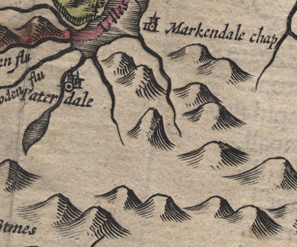 SP11NY41.jpg
 |
Goldrill Beck -- river -- NY393166
-- double line, runs into Ullswater; Westmorland
Grisedale Beck -- river -- NY36451437 ? -- wiggly line, from the tarn to Ullswater; Westmorland Howegrain Beck -- river -- NY44321990 ? -- double line, runs into Ullswater; Westmorland Patterdale -- building/s -- NY394160 -- 'Paterdale' -- circle, building, tower; Westmorland St Martin's Church -- church -- NY43421840 -- 'Markendale chap' -- circle, building, tower; Westmorland | |
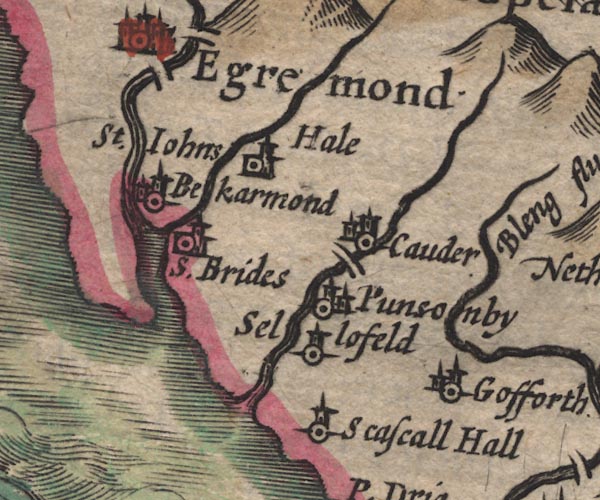 SP11NY00.jpg
 |
Beckermet -- building/s -- NY0106
-- 'St. Johns Bekarmond' -- circle, building, tower
Calder Bridge -- bridge -- NY042059 ? -- double line across the Calder Calder Bridge -- building/s -- NY041060 ? -- 'Cauder' -- circle, building, tower Calder, River -- river etc -- NY0712 (etc) ? -- double line with stream lines, runs into the sea Ehen, River -- river -- NY0515 (etc) ? -- double line with stream lines, runs into the sea Gosforth -- building/s -- NY070035 -- 'Gofforth' -- circle, building, tower Haile -- building/s -- NY0308 -- 'Hale' -- circle, building, tower Kirk Beck -- river -- NY0106 (?) -- wiggly line, runs into the Ehen at the sea Old Bridge (?) -- bridge -- NY010104 -- double line across the Ehen Ponsonby -- building/s -- NY039059 (? etc) -- 'Punsonby' -- circle, building, tower Seascale Hall -- building/s -- NY03920285 -- 'Scascall Hall' -- circle, tower Sellafield -- locality -- NY028040 (etc) -- 'Sellofeld' -- circle, tower St Bridget's Church -- church -- NY01480608 ? -- 'S. Brides' -- circle, building, tower | |
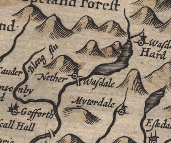 SP11NY10.jpg
 |
Bleng, River -- river -- NY1108
-- 'Bleng flu' -- wiggly line, runs into the Irt
Forest Bridge -- bridge -- NY12840375 ? ? -- double line across the Irt probably Lingmell Beck -- river -- NY1908 ? -- wiggly line, runs into Wast Water Miterdale -- valley -- NY1501 -- 'Myterdale' -- circle, tower Mosedale Beck -- river -- NY1808 -- wiggly line, runs into Wast Water Nether Wasdale -- building/s -- locality -- NY1204 (etc) -- 'Nether Wasdale' -- circle, tower St Olaf's Church -- church -- NY18850869 -- 'Wasdale chap.' -- circle, tower Wast Water -- lake -- NY161059 -- outline, shaded | |
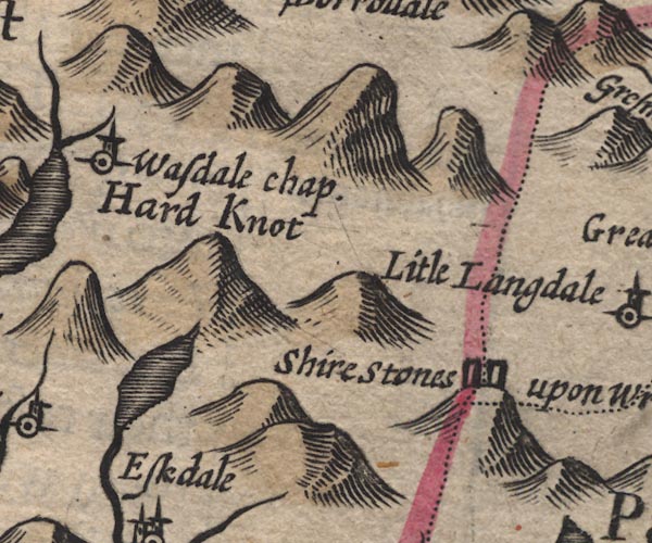 SP11NY20.jpg
 |
Burnmoor Tarn -- lake -- NY183043 ?
-- outline, shaded
Hard Knott -- hill -- NY23180237 -- 'Hard Knot' -- large hillock Three Shire Stones -- boundary stone -- stone -- county boundary mark -- NY27720274 ? -- 'Shire Stones upon Wrenose' -- two standing stones, on a hillock at the county boundaries | |
 SP11NY30.jpg
 | ||
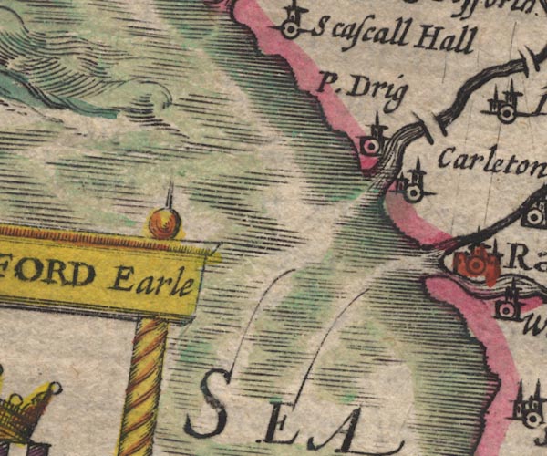 SP11SD09.jpg
 |
Carleton Hall -- building/s -- SD08249877
-- 'Carleton' -- circle, tower
Drigg -- building/s -- SD0698 -- 'P. Drig' -- circle, tower Esk, River -- river -- NY2101 (etc) ? -- 'Esk Flu' -- double line with stream lines, runs into the sea -- double line with stream lines, then a wiggly line Holme Bridge -- packhorse bridge -- bridge -- SD07709872 ? ? -- double line across the Irt probably Irt, River -- river etc -- NY1002 (etc) ? -- double line with stream lines, runs into the sea Mite, River -- river etc -- NY1602 -- double line with stream lines, runs into the sea | |
 SP11SD19.jpg
 |
Corney -- building/s -- SD115914 ?
-- 'Corno' -- circle, building, tower
Esk, River -- river -- NY2101 (etc) ? -- 'Esk Flu' -- double line with stream lines, runs into the sea -- double line with stream lines, then a wiggly line Irton -- locality -- NY1000 -- 'Irton' -- circle, building, tower Muncaster Castle -- castle -- haunted house -- SD103964 ? -- 'Momaster' -- circle, building, tower Ravenglass -- building/s etc -- SD085964 -- 'Rave~glas' -- circle, buildings, tower Santon Bridge -- bridge -- NY11020161 -- double line across the Irt Waberthwaite -- building/s -- SD104935 -- 'Warburthwat' -- circle, tower | |
 SP11SD29.jpg
 |
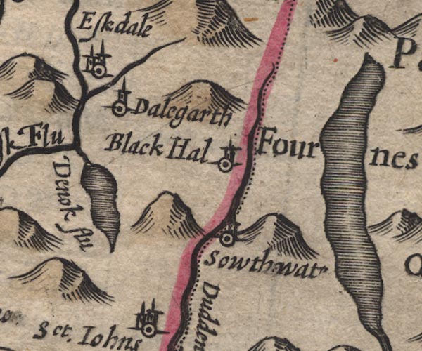
Black Hall -- building/s -- NY23920120 ? ?
-- 'Black Hal' -- circle, tower
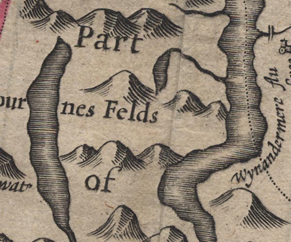
Coniston Water -- lake -- SD302943 -- outline, shaded; Lancashire Dalegarth Hall -- building/s -- NY17000012 ? -- 'Dalegarth' -- circle, tower Devoke Water -- lake -- SD158969 -- 'Devok flu' -- outline, shaded Duddon, River -- river -- NY2602 (etc) -- 'Dudden flu' -- wiggly line; county boundary -- double line; county boundary Eskdale -- valley -- locality -- NY1802 (etc) -- 'Eskdale' -- circle, building, tower Furness Fells -- hill -- fell -- SD3389 (etc) -- 'Part of Fournes Felds' -- hillocks; Lancashire Linbeck Gill -- river -- SD1497 -- wiggly line, from Devoke Water to the Esk Seathwaite -- building/s -- SD227960 ? -- 'Sowthwat' -- circle, tower; Lancashire Whillan Beck -- river -- NY1803 (etc) -- wiggly line, runs into the Esk | |
 SP11SD39.jpg
 | ||
 SP11SD18.jpg
 |
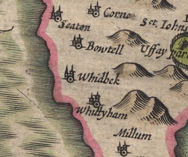
Bootle -- building/s etc -- SD108883
-- 'Bowtell' -- circle, building, tower
Seaton -- locality -- building/s -- SD1089 -- 'Seaton' -- circle, building, tower Whicham -- building/s -- SD132825 -- 'Whittyham' -- circle, building, tower Whitbeck -- building/s -- SD118845 -- 'Whidbeck' -- circle, towers | |
 SP11SD28.jpg
 |
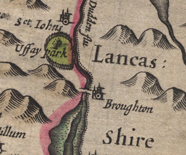
Broughton in Furness -- building/s etc -- SD211876
-- 'Broughton' -- circle, building, tower; Lancashire
Duddon Bridge -- bridge -- SD19928818 -- double line across the Duddon Duddon Estuary -- estuary -- river estuary etc -- SD1475 (etc) -- river channel, foreshore sands Duddon, River -- river -- NY2602 (etc) -- 'Dudden flu' -- wiggly line; county boundary -- double line; county boundary St John's Church -- church -- SD19799325 -- 'Sct. Johns' -- circle, tower Ulpha Park -- park -- SD187911 (etc) -- 'Uffay park' -- ring of fence palings, a tree | |
 SP11SD38.jpg
 | ||
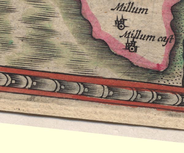 SP11SD17.jpg
 |
Millom Castle -- castle -- SD17128133
-- 'Millum cast' -- circle, building, tower
Millom -- building/s etc -- SD171801 -- 'Millum' -- circle, building, tower | |
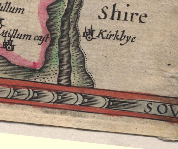 SP11SD27.jpg
 |
Duddon Estuary -- estuary -- river estuary etc -- SD1475
(etc)
-- river channel, foreshore sands
Duddon Sands -- foreshore etc -- SD2081 (etc) -- foreshore sands in Duddon Estuary Kirkby-in-Furness -- building/s -- SD226825 -- 'Kirkbye' -- circle, tower; Lancashire | |
 Lakes Guides menu.