 Otley 1818 SD27


|

|
|
|
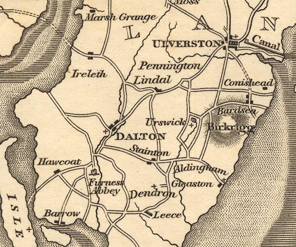
gazetteer links places may or may not be labelled on the map |
||

|
-- Aldingham |
|
|
|
-- Bardsea |
|
|
|
-- Barrow-in-Furness |
|
|
|
-- Birkrigg Common |
|
|
|
-- Dalton-in-Furness -- "DALTON" |
|
|
|
-- Dendron |
|
|
|
-- Furness Abbey |
|
|
|
-- Gleaston |
|
|
|
-- Great Urswick |
|
|
|
-- Hawcoat |
|
|
|
-- Ireleth |
|
|
|
-- Leece |
|
|
|
-- Lindal in Furness |
|
|
|
-- Pennington |
|
|
|
-- Stainton with Adgarley |
|
|
|
-- Ulverston -- "ULVERSTON" |
|
|
|
-- Urswick Tarn |
|
|
civil parishes The area roughly includes parts of parishes:- Dalton Town with Newton Aldingham Ulverston Osmotherley Egton with Newland Pennington Lindal and Marton Mansriggs Urswick Kirkby Ireleth Askam and Ireleth Barrow-in-Furness |
||
|
|
||
|
|
Lakes Guides menu. | |