 Ogilby 1675, plate 86
 |
 |
|
|
Places Identified
Strip map, road map, the Road from Tinmouth ... to Carlisle, scale about 1 inch to 1 mile, by John Ogilby, London, 1675. NB: each image includes an overlap, places in the overlap are not listed. The images are roughly 5 mile segments and are listed from finish to start. | ||
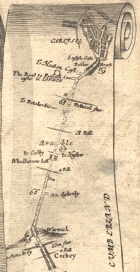 OG86m065.jpg
 |
Aglionby -- building/s -- NY4456
Botcherby -- building/s -- NY4155 Bothchergate -- street -- NY4055 Caldew, River -- river etc -- NY3851 (etc) ? Caldewgate -- locality -- NY3955 (etc) Carlisle Castle -- castle -- NY397563 Carlisle -- building/s -- roman site -- NY403558 Collar Beck -- river -- NY4256 (etc) Eden Bridge -- bridge -- NY400565 Eden, River -- river etc -- NY3658 (etc) English Gate -- town gate -- NY4055 (?) gallows, Carlisle -- gallows -- gibbet -- NY4154 (guess) Hustow (?) -- building/s -- NY4357 (guess) Hutton-in-the-Forest -- building/s -- NY460358 Irish Gate -- town gate -- NY4055 (?) Petteril, River -- river -- NY4935 (etc etc) Pow Maughan -- river -- NY4552 (etc etc) Powmaughan Bridge -- bridge -- NY44235621 Penrith to Carlisle -- route -- road -- NY53 ? -- 'The Road to Penrith Lancaster & LONDON' -- In mile 68, Cumberland. -- Turning left:- -- (See plate 38.) Scotby -- building/s -- NY441550 Scottish Gate -- town gate -- NY45 ? Warwick -- building/s -- NY465566 Wheelbarrow Hall -- building/s -- NY438563 Whoof House -- building/s -- NY444563 | |
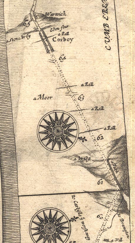 OG86m060.jpg
 |
Brampton Beck -- river -- NY5161
Brampton Park -- park -- NY5160 & NY5161 Brampton -- building/s -- NY530611 Bye Gill -- river -- NY5058 (etc) Capontree Hill -- hill -- NY5259 Corby Hill -- building/s -- NY478571 Eden, River -- river etc -- NY3658 (etc) Gelt, River -- river -- NY5456 (etc) ? Greenholme Beck -- river -- NY4957 (etc) Low Gelt Bridge -- bridge -- NY519591 Low Moor -- moor -- NY4957 Pottlebog Beck -- river -- NY5058 (etc) Trout Beck -- river -- NY4956 (etc) Warwick Bridge -- bridge -- NY46915671 | |
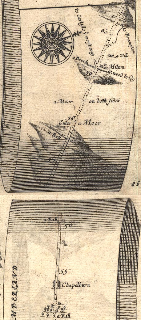 OG86m055.jpg
 |
-- hill -- NY558605
Carling Gill -- river -- NY6062 (etc) Carlisle -- building/s -- roman site -- NY403558 Castle Beck -- river -- NY5662 (etc) Low Row -- building/s -- NY585630 Milton Beck -- river -- NY5560 (etc) Milton Bridge -- bridge -- NY55336048 Milton Hill -- building/s -- NY549605 Milton -- building/s -- NY555605 Row Moor -- moor -- NY5862 (etc) | |
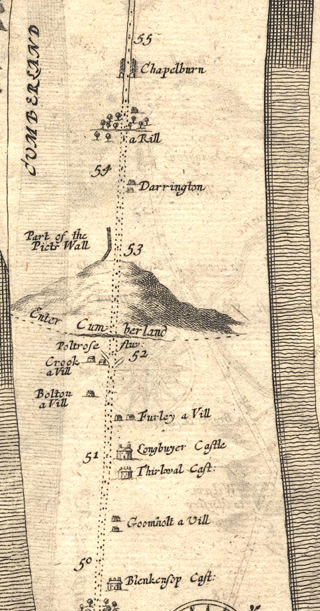 OG86m050.jpg
 |
Bolton (?) -- building/s -- NY6466 (?)
bridge, Gilsland -- bridge -- NY63356646 -- ford -- Road passing under the Poltrose Burn, from Northumberland to Cumberland. bridge, Upper Denton -- bridge -- NY63356645 Chapelburn -- building/s -- NY595645 Crooks -- building/s -- NY636661 Denton Mains -- building/s -- NY605651 Foul Town -- building/s -- NY646661 Greenhead -- building/s -- NY660654 Hadrian's Wall -- roman wall -- roman site etc -- NY6166 (etc) Longbyre -- building/s -- NY6566 Poltross Burn -- river -- NY634664 Thirlwall Castle -- castle -- NY659661 Upper Denton -- building/s -- NY616654 ? | |
 OG86m045.jpg
 |
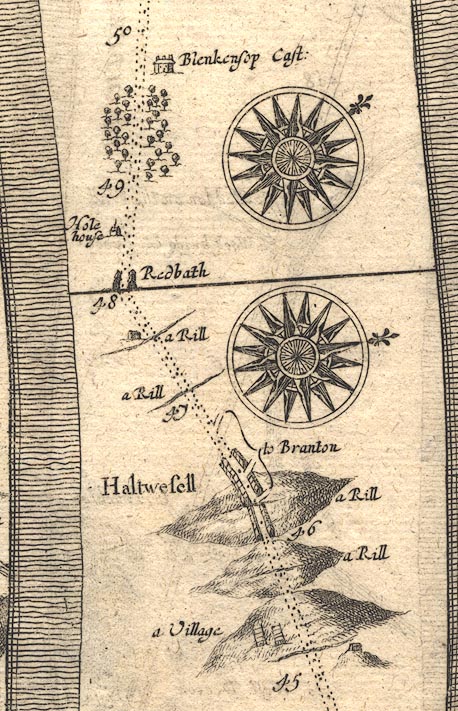
Blenkinsopp Castle -- castle -- NY664644
Brampton -- building/s -- NY530611 Haltwhistle -- building/s -- NY7064 Hole House -- building/s -- NY674638 Redpeth Farm -- building/s -- NY682624 Spittal, The -- building/s -- NY687637 Tipalt Burn -- river -- NY6963 Whitchester -- building/s -- NY7263 | |
 Lakes Guides menu.