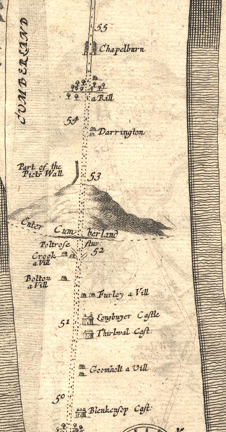
 Ogilby 1675, plate 86


|
|
|
|
|
gazetteer links places may or may not be labelled on the map |
||

|
-- Bolton -- (Bolton, Northumberland (OG86inc)) |
|
|
|
-- (bridge, Gilsland) |
|
|
|
-- (bridge, Upper Denton (OG86inc)) |
|
|
|
-- Chapelburn -- (Chapelburn, Nether Denton (OG86inc)) |
|
|
|
-- Crook -- (Crooks, Northumberland (OG86inc)) |
|
|
|
-- (Denton Mains, Upper Denton (OG86inc)) |
|
|
|
-- Furley -- (Foul Town, Northumberland (OG86inc)) |
|
|
|
-- Goomholt -- (Greenhead, Northumberland (OG86inc)) |
|
|
|
-- Picts Wall -- (Hadrian's Wall (OG86inc)) |
|
|
|
-- Longbuyer Castle -- (Longbyre, Northumberland (OG86inc)) |
|
|
|
-- Poltrose Fluvius -- (Poltross Burn (OG86inc)) |
|
|
|
-- Thirwal Castle -- (Thirlwall Castle, Northumberland
(OG86inc)) |
|
|
|
-- Darrington -- (Upper Denton (OG86inc)) |
|
|
county The area includes part of:- Northumberland |
||
|
civil parishes The route segment roughly includes parts of parishes:- Nether Denton Upper Denton |
Lakes Guides menu.