 Morden 1695
 |
 |
|
|
Places Identified
Map, uncoloured engraving, Cumberland, scale about 4 miles to 1 inch, by Robert Morden, 1695, published by Abel Swayle, Awnsham and John Churchill, 1695-1715? NB: each image includes an overlap, places in the overlap are not listed. The images are roughly equivalent to ngr 10Km squares and are listed from top left to bottom right. | ||
 MD12NY48.jpg
 |
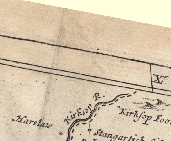
Kershope Burn -- river -- boundary -- NY5184 (etc
etc)
-- 'Kirksop R.' -- With the national boundary drawn
alongside.
Kershopefoot -- building/s -- NY475829 (?) ? -- 'Kirksop Foot' -- Circle. Liddel Water -- river -- NY4377 (etc) -- 'Kirksop R.' -- With the national boundary drawn alongside. | |
 MD12NY58.jpg
 | ||
 MD12NY68.jpg
 | ||
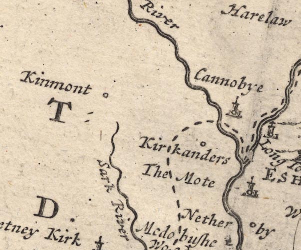 MD12NY37.jpg
 |
Canonbie -- building/s -- NY392764
-- 'Cannobye' -- Circle, building and tower.
Kinmont (?) -- building/s -- house -- NY37 -- 'Kinmont' -- Circle. Kirkandrews -- locality -- NY3569 (etc) -- 'Kirkanders' -- Circle. Moat -- building/s -- NY411739 ? -- 'The Mote' -- Circle, building and tower. Netherby -- building/s -- NY398715 -- 'Netherby' -- Circle. Sark, River -- river -- NY3372 (etc) -- 'Sark River' | |
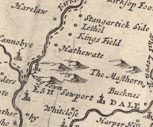 MD12NY47.jpg
 |
Eskdale Ward -- ward
-- 'ESHDALE WARD' -- Labelling the whole ward/hundred area.
Haithwaite -- building/s -- NY443773 ? -- 'Hathewate' -- Circle. Harelaw -- building/s -- NY4378 -- 'Harelaw' -- Circle. Kingfield -- locality -- NY4577 ? -- 'Kings Field' -- Circle. Liddel -- locality -- NY4679 ? -- 'Lethel' -- Circle. Longtown -- building/s -- NY381686 -- 'Long Town' -- Circle, building and tower. Carlisle to Berwick -- route -- road etc -- Single line. Solport -- locality -- NY4773 (?etc) -- 'Sowport' -- Circle, building and tower. Stonegarthside Hall -- building/s -- NY480819 ? -- 'Stangartick Side' -- Circle. Whiteclose -- building/s -- NY467709 -- 'Whitclose' -- Circle. | |
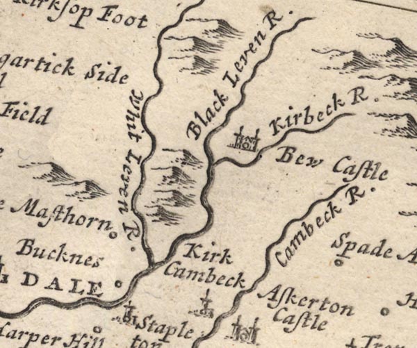 MD12NY57.jpg
 |
Bewcastle -- building/s -- NY5674
-- 'Bew Castle' -- Circle, building with two towers.
Black Lyne -- river -- NY5075 -- 'Whit Leven R.' Cam Beck -- river -- NY5469 (etc) -- 'Cambeck R.' High Mossthorn -- building/s -- NY514734 ? -- 'The Masthorn' -- Circle. Kirk Beck -- river -- NY5774 (etc) -- 'Kirbeck R.' Kirkcambeck -- building/s -- NY534689 -- 'Kirk Cambeck' -- Circle, building and tower. Low Luckens -- building/s -- NY493726 ? -- 'Bucknes' -- Circle. White Lyne -- river -- NY4973 (etc) -- 'Black Leven R.' | |
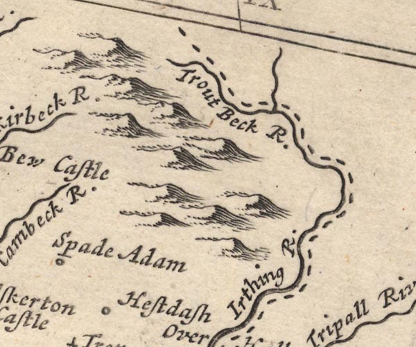 MD12NY67.jpg
 |
Gair Burn -- river -- boundary -- NY6278 (etc) ?
-- 'Trout Beck R.' -- With the county boundary drawn
alongside.
Highstead Ash -- building/s -- NY599692 -- 'Hestdash' -- Circle. Irthing, River -- river -- boundary -- county boundary -- NY4758 (etc) -- 'Irthing R.' -- With the county boundary drawn alongside. Spadeadam -- building/s -- NY585706 -- 'Spade Adam' -- Circle. | |
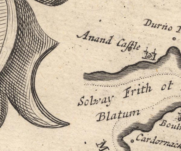 MD12NY16.jpg
 |
Annan Castle -- castle -- NY1966 (?)
-- 'Anand Castle' -- Circle, building with two towers.
Bowness-on-Solway -- building/s -- NY224628 -- 'Boulness / Blatum' -- Circle, building and tower. Solway Firth -- estuary -- river estuary -- sea area -- NY16 (etc) ? -- Solway Frith -- River estuary. | |
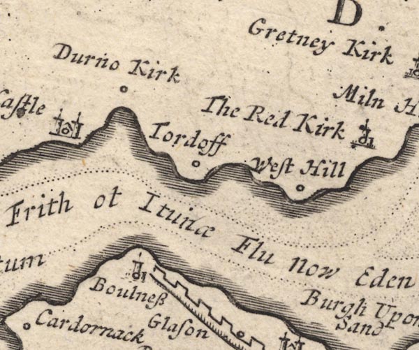 MD12NY26.jpg
 |
Bowness-on-Solway -- building/s -- NY224628
-- Boulness -- Circle, building and tower.
Dornock -- building/s -- NY231660 ? -- 'Durno Kirk' -- Circle. Hadrian's Wall -- roman wall -- roman site etc -- NY6166 (etc) -- Castelated wall. Solway Firth -- estuary -- river estuary -- sea area -- NY16 (etc) ? -- Solway Frith -- River estuary. Torduff -- locality -- NY264639 ? -- 'Tordoff' -- Circle. Westhills -- building/s -- NY272654 -- 'West Hill' -- Circle. | |
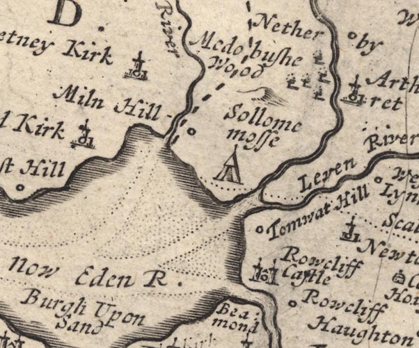 MD12NY36.jpg
 |
Gretna -- building/s -- NY317670
-- 'Gretney Kirk' -- Circle, building and tower.
Leven, River -- river etc -- SD3483 (etc) ? -- 'Leven River' -- Running into the sea. Medohush Wood (?) -- wood -- forest -- NY3669 -- 'Medobushe Wood' -- Trees. Mill Hill -- building/s -- NY340679 -- 'Miln Hill' -- Circle. Redkirk -- building/s -- NY300659 -- 'The Red Kirk' -- Circle, building and tower. Rockcliffe -- building/s -- NY3561 -- 'Rowcliff' -- Circle. Rockcliffe Castle (?) -- castle (?) -- NY3462 -- 'Rowcliff Castle' -- Circle, building with two towers. Solway Firth -- estuary -- river estuary -- sea area -- NY16 (etc) ? -- 'Solway Frith ot Itunae Flu now Eden R.' -- River estuary. Solway Moss -- moss -- NY3469 (etc) -- 'Sollome mosse' -- Labelling a tent symbol for a battle site or the moss itself. Battle of Solway Moss -- battle site -- NY3469 -- 'Sollome mosse' -- Labelling a tent symbol for a battle site or the moss itself. Todhills -- building/s -- NY3663 ? -- 'Tomwat Hill' -- Circle. | |
 MD12NY46.jpg
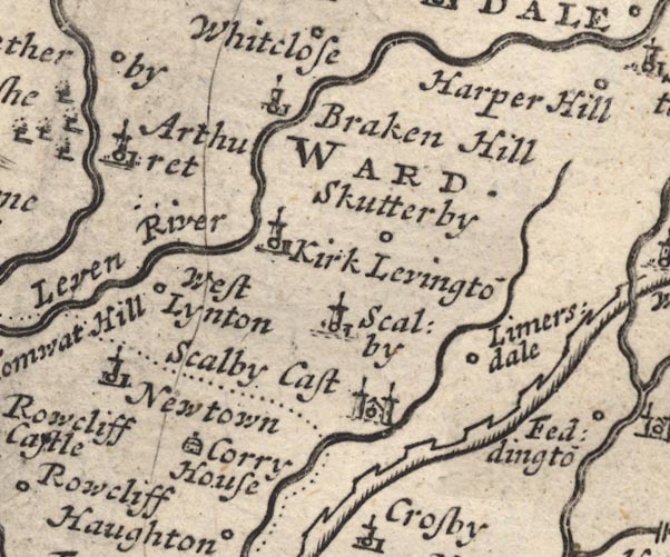
 |
Arthuret -- locality -- NY378676 ?
-- 'Arthuret' -- Circle, building and tower.
Brackenhill Tower -- tower -- NY445694 ? ? -- 'Braken Hill' -- Circle, building and tower. Corry House -- building/s -- NY492562 -- 'Corry House' -- Drawing of a house. Hadrian's Wall -- roman wall -- roman site etc -- NY6166 (etc) -- Castelated wall. Kirklinton -- building/s -- NY432670 -- 'Kirk Levinto~' -- Circle, building and tower. Laversdale -- building/s -- NY475625 -- 'Limersdale' -- Circle. Newtown of Rockcliffe -- building/s -- NY390625 -- 'Newtown' -- Circle, building and tower. Carlisle to Berwick -- route -- road etc -- Single line. Scaleby -- building/s -- NY4463 -- 'Scalby' -- Circle, building and tower. Scaleby Castle -- castle -- NY449624 -- 'Scalby Cast' -- Circle, building with two towers. Skitby -- building/s -- NY448657 -- 'Skutterby' -- Circle. Westlinton -- building/s -- NY393645 -- 'West Lynton' -- Circle. | |
 MD12NY56.jpg
 |
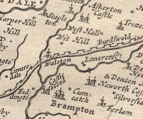
Askerton Castle -- castle -- NY5569 ?
-- 'Askerton Castle' -- Circle, building with two towers.
Brampton -- building/s -- NY530611 -- 'Brampton' -- Circle, buildings, towers. Castlesteads -- building/s -- NY511632 ? -- 'Castle Steed' -- Circle, building with two towers. Cumcatch -- building/s -- NY547611 -- 'Cumcatch' -- Circle. Denton Hall -- building/s -- NY578630 -- 'Denton Hall' -- Drawing of a house. Farlam -- building/s -- NY5558 -- 'Ferlam' -- Circle, building and tower. Hadrian's Wall -- roman wall -- roman site etc -- NY6166 (etc) -- Castelated wall. Harperhill -- building/s -- NY501716 -- 'Harper Hill' -- Circle. Irthington -- building/s -- NY4961 ? ? -- 'Fedingto~' -- Circle. Lanercost Bridge -- bridge -- NY55346331 -- Double line over a stream, over the Irthing. Lanercost Priory -- priory -- religious house -- NY55626373 (etc) -- 'Lanercost:' -- Circle with a cross. Naworth Castle (?) -- castle -- NY559625 ? -- 'Naworth Castle' -- Circle, building with two towers. Silver Side -- building/s -- NY577607 -- 'Silverside' -- Circle. Stapleton -- building/s -- NY505712 -- 'Stapleton' -- Circle, building and tower. Walton -- building/s -- NY5264 -- 'Waleton' -- Circle, building and tower. West Hall -- building/s -- NY566677 -- 'West Hall' -- Circle. White Hill -- building/s -- NY536659 -- 'Wit Hill' -- Circle. | |
 MD12NY66.jpg
 |
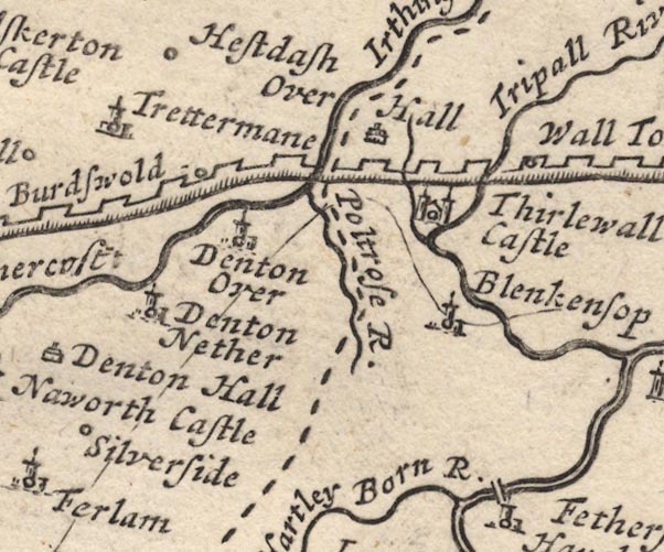
Birdoswald -- building/s -- NY6166
-- 'Burdswold' -- Circle.
Blenkinsopp Hall -- building/s -- NY681641 ? -- 'Blenkensop' -- Circle, building and tower. bridge, Blenkinsopp -- bridge -- NY666646 -- ford -- bridge -- Single line over the Tripall River by Blenkensop. bridge, Gilsland -- bridge -- NY63356646 -- ford -- bridge -- Single line over the Poltrose Burn. Hadrian's Wall -- roman wall -- roman site etc -- NY6166 (etc) -- Castelated wall. Hartley Burn -- river -- NY6760 -- 'Hartley Born R.' Nether Denton -- locality -- NY5964 (?) -- 'Denton Nether' -- Circle, building and tower. Over Hall (?) -- building/s -- house -- NY6367 (roughly) -- 'Over Hall' -- Drawing of a house. Poltross Burn -- river -- NY634664 -- 'Poltrose R.' -- With the county boundary drawn alongside. Thirlwall Castle -- castle -- NY659661 -- 'Thirlewall Castle' -- Circle, building with two towers. Tipalt Burn -- river -- NY6963 -- 'Tripall River' Triermain -- building/s -- NY593667 -- 'Trettermane' -- Circle, building and tower. Upper Denton -- building/s -- NY616654 ? -- 'Denton Over' -- Circle, building and tower. Walltown -- building/s -- NY679665 -- 'Wall Towne' -- Circle. | |
 MD12NY76.jpg
 |
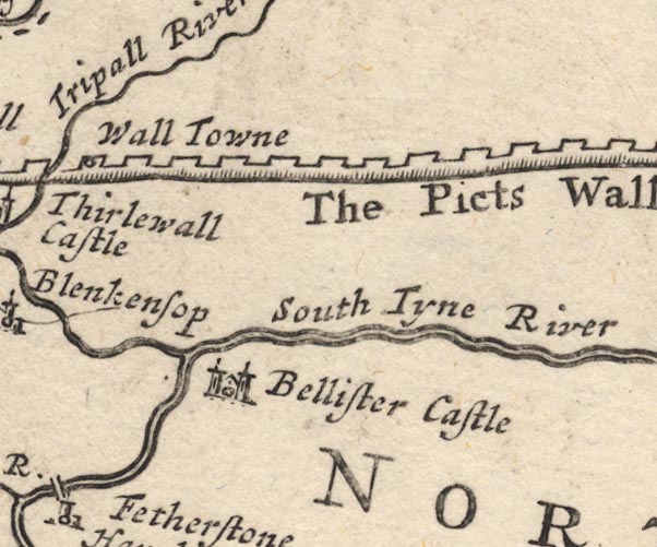
Bellister Castle -- castle -- NY701629
-- 'Bellister Castle' -- Circle, building with two towers.
Hadrian's Wall -- roman wall -- roman site etc -- NY6166 (etc) -- 'The Picts Wall' -- Castelated wall. South Tyne, River -- river -- NY7441 (etc) ? -- 'South Tyne River' | |
 MD12NY05.jpg
 | ||
 MD12NY15.jpg
 |
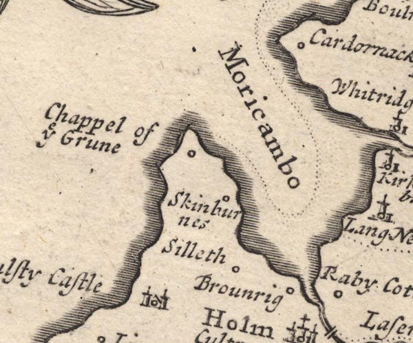
Brownrigg -- building/s -- NY1652
-- 'Brounrig' -- Circle.
Cardurnock -- building/s -- NY1758 -- 'Cardornack' -- Circle. Chappel of ye Grune -- chapel (gone) -- church -- NY1456 -- 'Chappel of ye Grune' -- Circle. Moricambe -- bay -- foreshore -- NY1656 (etc) -- 'Moricambo' -- Sea are, bay. Raby Cote -- building/s -- NY1752 -- 'Raby Cotes' -- Circle. Silloth -- building/s -- NY1153 -- 'Silleth' -- Circle. Skinburness -- building/s -- NY1255 -- 'Skinburnes' -- Circle. Wolsty Castle (?) -- castle -- NY1050 -- 'Wulsty Castle' -- Circle, building with two towers. | |
 MD12NY25.jpg
 |
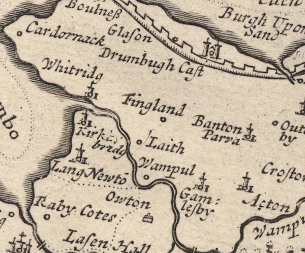
Aikton -- building/s -- NY2753
-- 'Acton' -- Circle, building and tower.
Drumburgh Castle -- castle -- NY2659 -- 'Drumbugh Cast' -- Circle, building with two towers. Fingland -- building/s -- NY2557 -- 'Fingland' -- Circle. Gamelsby -- building/s -- NY2552 -- 'Gamlesby' -- Circle, building and tower. Glasson -- building/s -- NY2560 -- 'Glason' -- Circle. Hadrian's Wall -- roman wall -- roman site etc -- NY6166 (etc) -- Castelated wall. Kirkbride -- building/s -- NY229568 -- 'Kirkby bridg' -- Circle, building and tower. Laythes -- building/s -- NY2455 -- 'Laith' -- Circle. Little Bampton -- building/s -- NY2755 -- 'Banton Parva' -- Circle, building and tower. Newton Arlosh -- building/s -- NY1955 ? ? -- 'Lang Newto~' -- Circle, building and tower. Oulton -- building/s -- NY2450 -- 'Owton' -- Drawing of a house. Wampool -- building/s -- NY2454 -- 'Wampul' -- Circle. Whitrigg -- building/s -- NY2257 -- 'Whitridg' -- Circle, building and tower. | |
 MD12NY35.jpg
 |
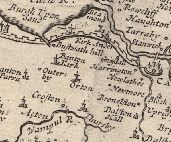
Beaumont -- building/s -- NY3459
-- 'Beamond' -- Circle, building and tower.
Boustead Hill -- building/s -- NY2959 -- 'Bustwath hill' -- Circle. Brownelson -- hill -- NY3852 -- 'Bronelston' -- Circle. Burgh by Sands -- building/s -- NY323591 -- 'Burgh Upon Sand' -- Circle, building and tower; there is also a deleted label. Caldew Bridge -- bridge -- NY395560 -- Double line over the Caldew, W of Carlisle. Caldew, River -- river etc -- NY3851 (etc) ? -- Running into the Eden. Crofton Bridge -- bridge -- NY308494 -- Double line over the Wampool, near Croston. Crofton -- NY3050 -- 'Croston' -- Circle, building and tower. Dalston Hall -- building/s -- NY3751 -- 'Dalston Hall' -- Drawing of a house. Great Orton -- building/s -- NY3254 -- 'Orton' -- Circle, building and tower. Grinsdale -- building/s -- NY3658 -- 'Grinsdall' -- Circle. Hadrian's Wall -- roman wall -- roman site etc -- NY6166 (etc) -- Castelated wall. Harington (?) -- building/s -- NY3956 -- 'Harrington' -- Circle. Kirkandrews upon Eden -- building/s -- NY3558 -- 'Kirk Ander' -- Circle, building and tower. Kirkbampton -- building/s -- NY3056 -- 'Banton Kirk' -- Circle, building and tower. Newby West -- building/s -- NY3653 ? ? -- 'Newmore' -- Circle. Newlathes (?) -- building/s -- NY3955 -- 'Newlathes' -- Circle. Oughterby -- building/s -- NY2955 -- 'Outerby' -- Circle. Cockermouth to Carlisle -- road -- route -- NY13 -- Single line. Thursby -- building/s -- NY3250 -- 'Thursby' -- Circle, building and tower. Wampool, River -- river etc -- NY2453 (etc) ? -- 'Wampul R.' Whinnow Beck -- river -- NY2950 (etc) -- Running past Thursby and into the Wampool. | |
 MD12NY45.jpg
 |
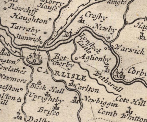
Aglionby -- building/s -- NY4456
-- 'Aglionby' -- Circle.
Blackhall Park -- building/s -- NY4149 ? -- 'Blaeck Hall' -- Drawing of a house. Botcherby -- building/s -- NY4155 -- 'Botcherby' -- Circle. Brisco -- building/s -- NY410519 -- 'Brisco' -- Circle, building and tower. Brunstock Beck -- river -- NY4261 -- Running by Scaleby and into the Eden at Carlisle. Carleton -- building/s -- NY428528 -- 'Carlton' -- Circle, building and tower. Carlisle -- building/s -- roman site -- NY403558 -- 'CARLISLE' -- Circle, buildings and towers, with a town wall. Crosby on Eden -- building/s -- NY465597 -- 'Crosby' -- Circle, building and tower. Eden Bridge -- bridge -- NY400565 -- Double line over a stream, over the Eden at Carlisle. Hadrian's Wall -- roman wall -- roman site etc -- NY6166 (etc) -- Castelated wall. Houghton -- building/s -- NY4059 -- 'Haughton' -- Circle. Linstock Castle -- castle -- peel -- NY429584 -- 'Lynstock Castle' -- Circle, building with two towers. Newbiggin House -- building/s -- NY433509 -- 'Newbiggin' -- Circle, building and tower. Newby East -- building/s -- NY475581 -- 'Newby' -- Circle. Pow Maughan -- river -- NY4552 (etc etc) -- Running by Aglionby and into the Eden. Carlisle to Berwick -- route -- road etc -- Single line. Penrith to Carlisle -- route -- road -- NY53 ? -- Single line. Stanwix -- building/s -- NY3957 -- Circle. Tarraby -- building/s -- NY409581 -- 'Tarraby' -- Circle. Upperby -- building/s -- NY4053 ? -- 'Uprightby' -- Circle, building and tower. Warwick Bridge -- bridge -- NY46915671 -- Double line over a stream, over the Eden at Warwick. Warwick -- building/s -- NY465566 -- 'Warwick' -- Circle. Wetheral -- building/s -- NY4654 -- 'Wetherall' -- Circle, building and tower. | |
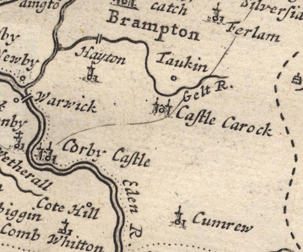 MD12NY55.jpg
 |
Castle Carrock -- building/s -- NY5455
-- 'Castle Carock' -- castle -- Circle, building with two
towers.
Corby Castle -- castle -- NY4754 -- 'Corby Castle' -- Circle, building with two towers. Cote Hill -- building/s -- NY508561 -- 'Cote Hill' -- Circle. Cumrew -- building/s -- NY5450 -- 'Cumrew' -- Circle, building and tower. Eden, River -- river etc -- NY3658 (etc) -- 'Eden R.' Gelt, River -- river -- NY5456 (etc) ? -- 'Gelt R.' Hayton -- building/s -- NY5057 ? -- 'Hayton' -- Circle, building and tower. Low Gelt Bridge -- bridge -- NY519591 -- Double line over the Gelt N of Hayton. Talkin -- building/s -- NY549573 -- 'Taukin' -- Circle. | |
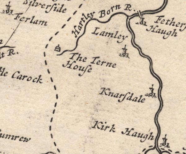 MD12NY65.jpg
 |
Featherstone -- locality -- NY6760
-- 'Fetherstone Haugh' -- Circle, building and tower.
Knarsdale -- building/s -- NY6754 -- 'Knarsdale' -- Circle, building and tower. Lambley -- building/s -- NY6758 -- 'Lamley' -- Circle, building and tower. Tarn House -- building/s -- NY605584 -- 'The Terne House' -- Drawing of a house. | |
 MD12NY75.jpg
 | ||
 MD12NY04.jpg
 |
Allonby -- building/s -- NY0843
-- 'Allonby' -- Circle.
Crosby -- building/s -- NY0738 ? -- 'Crosby' -- Circle, building and tower. Dubmill (?) -- building/s -- NY0745 -- 'Dubmill' -- Circle. | |
 MD12NY14.jpg
 |
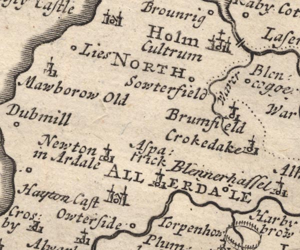
Abbey Town -- building/s -- NY1750
-- 'Holm Cultrum' -- Circle, buildings, towers, with a
cross; the first word upright, the second italic.
Allerdale below Derwent Ward -- ward -- 'NORTH ALLERDALE WARD' -- Labelling the ward area. Aspatria -- building/s -- NY1441 -- 'Aspatrick' -- Circle, building and tower. Blennerhasset -- building/s -- NY1741 -- 'Blennerhasse[t]' -- Circle. bridge, Holme Abbey -- bridge -- NY184514 -- Double line over the Waver at Holm Coultram. Bromfield -- building/s -- NY1746 -- 'Brumfield' -- Circle, building and tower. Crookdake -- building/s -- NY1943 -- 'Crokedake' -- Circle, building and tower. Hayton Castle -- castle -- NY1041 -- 'Hayton Cast' -- Circle, building with two towers. Holme Coultram Abbey -- abbey (site) -- religious house -- NY177509 -- 'Holm Cultrum' -- Circle, buildings, towers, with a cross; the first word upright, the second italic. Langrigg Beck -- river -- NY1646 (etc) -- 'Waver' Lowsay -- building/s -- NY1148 ? -- 'Lies' -- Circle. Mawbray -- building/s -- NY0846 -- 'Mawborow Old' -- Circle, building and tower. Oughterside -- building/s -- NY1140 -- 'Owterside' -- Circle. Southerfield -- building/s -- NY1648 -- 'Sowterfield' -- Circle. Westnewton -- building/s -- NY1344 -- 'Newton in Ardale' -- Circle, building and tower. | |
 MD12NY24.jpg
 |
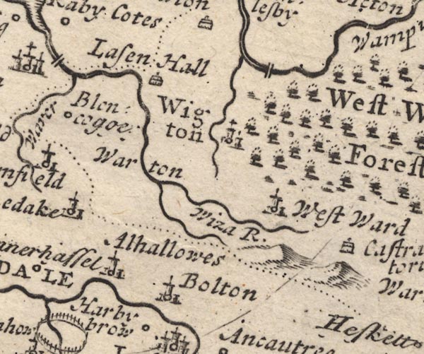
Allhallows -- locality -- NY1842
-- 'Alhallowes' -- Circle, building and tower.
Blencogo -- building/s -- NY1947 -- 'Blencog[g]e[y]' -- Circle. Boltongate -- building/s -- NY229407 -- 'Bolton' -- Circle, building and tower. bridge, Woodside -- bridge -- NY279499 -- Double line over the Wampool N of Wigton. Lessonhall -- building/s -- NY2250 -- 'Lasen Hall' -- Drawing of a house. Little Waver -- river -- NY2343 (etc) -- Running into the Waver which is labelled Wiza. Cockermouth to Carlisle -- road -- route -- NY13 -- Single line. Waver, River -- river etc -- NY2344 (etc) -- 'Wiza R.' Waverton -- building/s -- NY2247 ? ? -- 'Warton' -- No symbol. Westward -- building/s -- NY2744 -- 'West Ward' -- Circle, building and tower. Wigton -- building/s -- NY255484 -- 'Wigton' -- Circle, buildings, towers. Wiza Beck -- river -- NY2745 (etc) -- Running into the Wampool. | |
 MD12NY34.jpg
 |
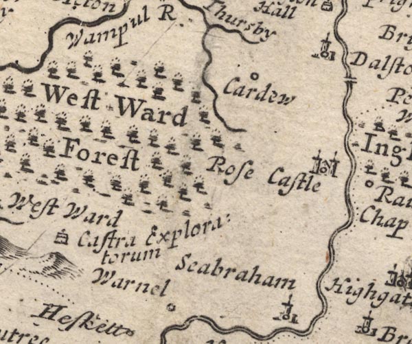
Cardew -- building/s -- NY3449
-- 'Cardew' -- Circle.
Dalston -- building/s -- NY3650 -- 'Dalston' -- Circle, building and tower. Cockermouth to Carlisle -- road -- route -- NY13 -- Single line. Castra Exploratorum -- roman fort -- roman site -- NY283422 (about) -- 'Castra Exploratorum' -- Drawing of a house. Rose Castle -- bishop's palace -- palace -- castle -- NY3746 -- 'Rose Castle' -- Circle, building with two towers. Warnell -- building/s -- NY3441 -- 'Warnel' -- Circle. Westward Forest (?) -- forest -- NY34 (?) -- 'West Ward Forest' -- Forest, tree symbols. | |
 MD12NY44.jpg
 |
bridge, Dalston -- bridge -- NY370487 ?
-- Double line over the Cauda by Dalston.
Calthwaite -- building/s -- NY469401 -- 'Cauthwate' -- Circle, building and tower. High Head Castle -- castle -- NY40214339 ? ? -- 'Highgate Castle' -- Circle, building with two towers. High Hesket -- building/s -- NY476445 ? -- 'Hesket' -- Circle, building and tower. Inglewood Forest -- forest -- 'Inglewood Forest' -- Forest, tree symbols. Itonfield -- locality -- NY426432 ? -- 'Itenfield' -- Circle, building and tower. Petteril, River -- river -- NY4935 (etc etc) -- 'Petterel River' Raughton Head -- building/s -- NY3845 -- 'Raughton Chap' -- Circle. Penrith to Carlisle -- route -- road -- NY53 ? -- Single line. Wreay -- building/s -- NY435489 ? -- 'Petterell Wrey' -- Circle, building and tower. | |
 MD12NY54.jpg
 |
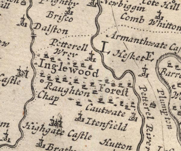
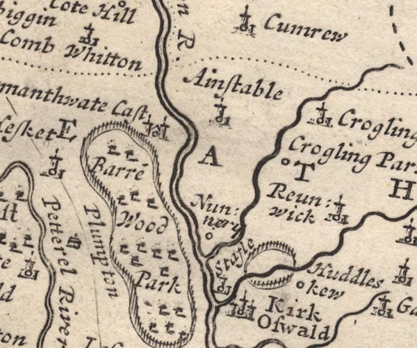
Ainstable -- building/s -- NY5346
-- 'Ainstable' -- Circle, building and tower.
Armathwaite Place -- building/s -- peel -- castle -- NY50584589 -- 'Armanthwate Cast' -- Circle, building with two towers. Baronwood Park -- park -- NY5241 -- 'Barre~ Wood Park' -- Ring of fence palings, trees. Croglin Low Hall -- building/s -- NY554450 ? ? -- 'Crogling Parva' -- Circle. Croglin Water -- river -- NY5746 (etc) -- Running into the Eden at Nunnery. Croglin -- building/s -- NY5747 -- 'Crogling Church' -- Circle, building and tower. Cumwhitton -- building/s -- NY5052 -- 'Comb Whitton' -- Circle, building and tower. Huddlesceugh Hall -- building/s -- NY597422 ? -- 'Huddleskew' -- Circle. Kirkoswald -- building/s -- NY5541 -- 'Kirk Oswald' -- Circle, buildings, towers. Leath Ward -- ward -- 'LEATH WARD' -- Labelling a large area. Nunnery -- building/s -- NY537428 -- 'Nunnery' -- Circle. Plumpton Wall -- building/s -- NY497371 -- 'Plumpton' -- Drawing of a house. Raven Beck -- river -- NY5942 (etc) -- Running into the Eden at Kirk Oswald. Renwick -- building/s -- NY597435 -- 'Reunwick' -- Circle, building and tower. Penrith to Carlisle -- route -- road -- NY53 ? -- Single line. St John's Church -- church -- NY57464726 -- 'Crogling Church' -- Circle, building and tower. Staffield Park (?) -- park -- NY5442 (?) -- Ring of fence palings, trees, north of Kirk Oswald. Staffield -- building/s -- NY542428 -- 'Stafle' -- Circle, building and tower. | |
 MD12NY64.jpg
 |
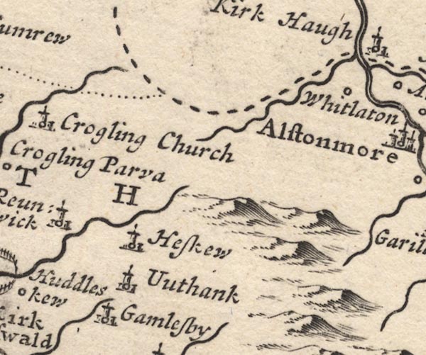
Gamblesby -- building/s -- NY609393
-- 'Gamlesby' -- Circle, building and tower.
Gilderdale Burn -- river -- county boundary -- boundary -- NY704489 -- Running into the South Tyne; with the county boundary drawn alongside. Haresceugh -- building/s -- NY609428 -- 'Heskew' -- Circle, building and tower. Unthank -- building/s -- NY609404 -- 'Uuthank' -- Circle, building and tower. Whitley (?) -- locality -- NY6948 (approx) -- 'Whitlaton' -- Circle. | |
 MD12NY74.jpg
 |
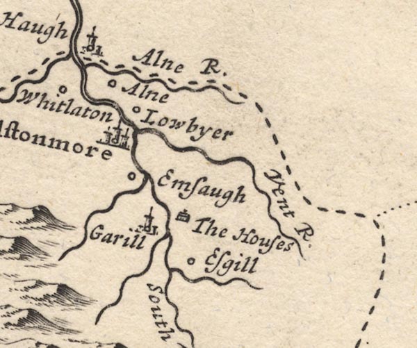
Alston -- building/s -- NY719465
-- 'Alstonmoor' -- Circle, buildings, towers.
Ash Gill -- river -- NY7540 (etc) -- Running into the South Tyne by Esgill. Ashgillside -- building/s -- NY7540 ? ? -- 'Esgill' -- Circle. Ayle Burn -- river -- NY7149 -- 'Alne R.' -- Running into the South Tyne; with the county boundary drawn alongside. Ayle -- building/s -- NY7149 -- 'Alne' -- Circle. Black Burn -- river -- NY6841 -- Running into the South Tyne near Emsaugh. Cross Gill -- river -- NY7440 (etc) -- Running into the South Tyne near Garill. Garrigill -- building/s -- NY744415 ? -- 'Garill' -- Circle, building and tower. Kirkhaugh -- building/s -- NY6949 -- 'Kirk Haugh' -- Circle, building and tower. Low Ameshaugh -- building/s -- NY711439 -- 'Emsaugh' -- Circle. Low Byre (?) -- building/s -- NY721476 (roughly) -- 'Lowbyer' -- Circle. Nent, River -- river -- NY7446 (etc etc) -- 'Vent R.' Pasture Houses -- building/s -- NY749412 ? ? -- 'The Houses' -- Drawing of a house. | |
 MD12NX93.jpg
 | ||
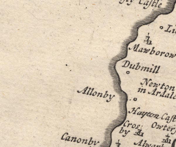
 MD12NY03.jpg
 |
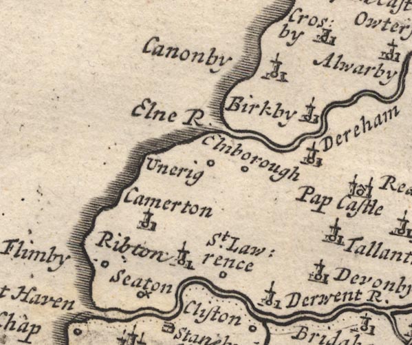
Birkby -- building/s -- NY0637
-- 'Birkby' -- Circle, building and tower.
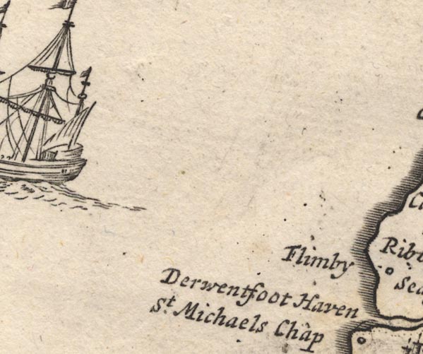
Camerton -- building/s -- NY0330 ? -- 'Ribton' -- Circle, building and tower. Crosscanonby -- building/s -- NY0738 ? -- 'Canonby' -- Circle, building and tower. Dearham -- building/s -- NY0736 -- 'Dereham' -- Circle, building and tower. Derwent Foot -- river mouth -- bay -- NY231273 -- 'Derwentfoot Haven' -- quay -- wharf -- River mouth. Derwent, River -- river etc -- NY2515 (etc) ? -- 'Derwent R.' Dovenby -- building/s -- NY0933 -- 'Devonby' -- Circle, building and tower. Ellen, River -- river etc -- NY2436 (etc) -- 'Elne R.' Ellenborough -- building/s -- NY0435 -- 'Elnborough' -- Circle. Ewanrigg Hall -- building/s -- NY0435 -- 'Unerig' -- Circle. Flimby -- building/s -- NY0233 ? -- 'Flimby' -- Circle. Ribton Hall -- building/s -- NY0430 ? -- 'St. Lawrence' -- Circle. Seaton -- building/s -- NY0130 -- 'Seaton' -- Circle with a cross. St Lawrence Chapel -- church -- chapel -- NY060304 -- '' -- Circle, building and tower, unlabelled. Tallentire -- building/s -- NY1035 -- 'Tallantire' -- Circle, building and tower. | |
 MD12NY13.jpg
 |
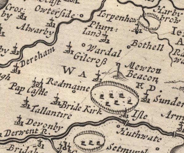
Allerby -- building/s -- NY0839
-- 'Alwarby' -- Circle, building and tower.
Mewton Beacon -- beacon -- -- 'Mewton Beacon' -- Hillock, post with rungs, and hanging cresset. Bothel -- building/s -- NY1838 -- 'Bothell' -- Circle. Bridekirk -- building/s -- NY1133 -- 'Bride Kirk' -- Circle, building and tower. bridge, Isel -- bridge -- NY164334 -- Double line over the Derwent, near Isel. Gilcrux -- building/s -- NY1138 -- 'Gilcross' -- Circle, building and tower. Hewthwaite Hall -- building/s -- NY152328 -- 'Huthwaite' -- Circle. Isel Park -- park -- NY1534 -- Ring of fence palings, trees. Isel -- locality -- NY1633 -- 'Isle' -- Circle, building and tower. Papcastle -- building/s -- NY1031 -- 'Pap Castle' -- Circle, building with two towers. park, Ireby -- park -- NY212402 -- Ring of fence palings, no trees, near Torpenhow. Plumbland -- building/s -- NY1539 -- 'Plumland' -- Circle, building and tower. Redmain -- building/s -- NY1333 -- 'Redmaine' -- Circle, or circle, building and tower; two symbols, one label. Cockermouth to Carlisle -- road -- route -- NY13 -- Single line. Sunderland -- building/s -- NY1735 -- 'Sunderland' -- Circle, building and tower. Torpenhow -- building/s -- NY2039 -- 'Torpenhow' -- Circle, building and tower. Wardhall Guards -- building/s -- NY1338 -- 'Wardal' -- Circle. | |
 MD12NY23.jpg
 |
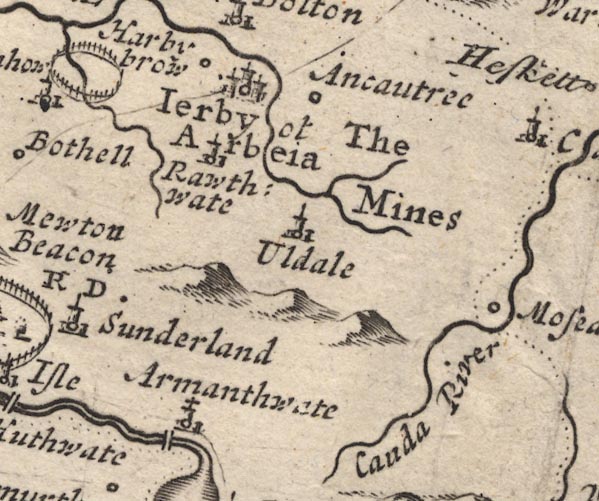
Armathwaite Hall -- building/s -- hotel -- NY2032
-- 'Armanthwate' -- Circle, building and tower, the tower
has a cross.
Aughertree -- building/s -- NY2538 -- 'Ancautree' -- Circle. Caldew, River -- river etc -- NY3851 (etc) ? -- 'Cauda River' -- Running into the Eden. Harbybrow -- building/s -- NY1941 -- 'Harby brow' -- Circle. Ireby -- building/s etc -- NY238388 -- 'Ierby ot Arbeia' -- Circle, buildings, towers. Ouse Bridge -- bridge -- NY199321 -- Double line over a stream, over the Derwent at Armanthwaite. Cockermouth to Carlisle -- road -- route -- NY13 -- Single line. Keswick to Cockermouth -- road -- route -- NY22 -- Single line. Roughtongill Mines -- copper mine -- lead mine -- mine -- zinc mine -- mine -- NY298339 & NY309345 -- 'The Mines' -- No symbols. Ruthwaite -- building/s -- NY237367 -- 'Rawthwate' -- Circle, building and tower. Uldale -- building/s -- NY2436 -- 'Uldale' -- Circle, building and tower. | |
 MD12NY33.jpg
 |
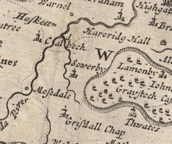
Caldbeck -- building/s -- NY3239
-- 'Caldbeck' -- Circle, building and tower.
Gillcambon Beck -- river -- NY3835 (etc) -- Running into the Caldew near Caldbeck. Greenthwaite Hall -- building/s -- NY43153021 -- 'Thwates' -- Circle, building and tower. Hesket Newmarket -- building/s etc -- NY340386 -- 'Heskett' -- Circle. Mosedale -- building/s -- NY3532 ? -- 'Mosedale' -- Circle. Mungrisdale -- building/s -- NY3630 -- 'Grisdall Chap' -- Circle, building and tower. Sebergham -- building/s -- NY357418 -- 'Seabraham' -- Circle, building and tower. Sowerby Hall -- building/s -- NY3836 -- 'Sowerby' -- Circle, building and tower. St Kentigern's Church -- church -- NY36353043 -- 'Grisdall Chap' -- Circle, building and tower. | |
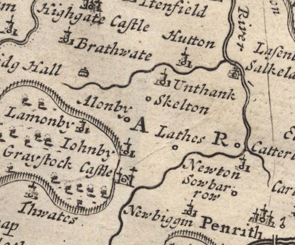 MD12NY43.jpg
 |
Catterlen -- building/s -- NY4833
-- 'Catterlen' -- Circle.
Ellonby -- building/s -- NY425354 -- 'Alonby' -- Circle. Greystoke Castle -- castle -- park -- NY425309 (castle) -- 'Graystock Castle' -- Circle, building with two towers; ring of fence palings, trees. Hardrigg Hall -- building/s -- NY425362 -- 'Hareridg Hall' -- Drawing of a house. Hutton-in-the-Forest -- building/s -- NY460358 -- 'Hutton' -- Circle, building and tower. Johnby -- building/s -- NY432331 -- 'Iohnby' -- Circle, building and tower. Laithes -- building/s -- NY464329 -- 'Laithes' -- Circle. Lamonby -- building/s -- NY409358 -- 'Lamonby' -- Circle, building and tower, in the park. Low Braithwaite -- building/s -- NY426422 -- 'Brathwate' -- Circle, building and tower. Newbiggin -- building/s -- NY4629 -- 'Newbiggin' -- Circle, building and tower. Newton Reigny -- building/s -- NY4731 -- 'Newton' -- Circle, building and tower. Old Petterill -- river -- NY48983692 -- Running by Unthank and into the Petteril. Randerside Hall (?) -- building/s -- house -- NY4836 ? -- Drawing of a house, or circle with a cross; its label is erased. Sewborwens -- building/s -- NY491302 -- 'Sowbarrow' -- Circle. Skelton -- building/s -- NY4335 -- 'Skelton' -- Circle. Unthank -- building/s -- NY452362 -- 'Unthank' -- Circle, building and tower. | |
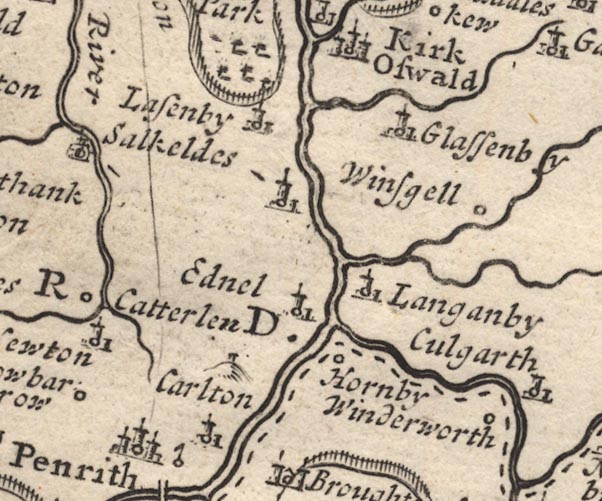 MD12NY53.jpg
 |
Beacon Hill -- hill -- beacon (?) -- NY5231
-- Hillock with a small tower.
Briggle Beck -- river -- NY5833 (etc) -- Running into the Eden north of Langanby. Carleton -- building/s -- NY5329 -- 'Carlton' -- Circle, building and tower. Edenhall -- building/s -- NY565324 -- 'Ednel' -- Circle, building and tower. Glassonby -- building/s -- NY576388 -- 'Glassenby' -- Circle, building and tower. Great Salkeld -- building/s -- NY5536 -- 'Salkeldes' -- Circle, building and tower. Hazelrigg Beck -- river -- NY6040 (etc) -- Running by Glassenby and into the Eden. Hornby Hall -- building/s -- NY5629 ? ? -- 'Hornby' -- Circle. Langwathby -- building/s -- NY5633 -- 'Langanby' -- Circle, building and tower. Lazonby -- building/s -- NY5439 -- 'Lasenby' -- Circle, building and tower. Little Salkeld -- building/s -- NY566361 -- 'Salkeldes' -- Circle, building and tower. Penrith Beacon -- beacon -- NY52123138 -- Small tower on a hillock. Penrith to Carlisle -- route -- road -- NY53 ? -- Single line. Robberby Water -- river -- NY561359 -- Running into the Briggle Beck. Thacka Beck -- river -- NY49173297 -- Running into the Petteril. Winderwath -- building/s -- NY597294 -- 'Winderworth' -- Circle. Winskill -- building/s -- NY580349 -- 'Winsgell' -- Circle. | |
 MD12NY63.jpg
 |
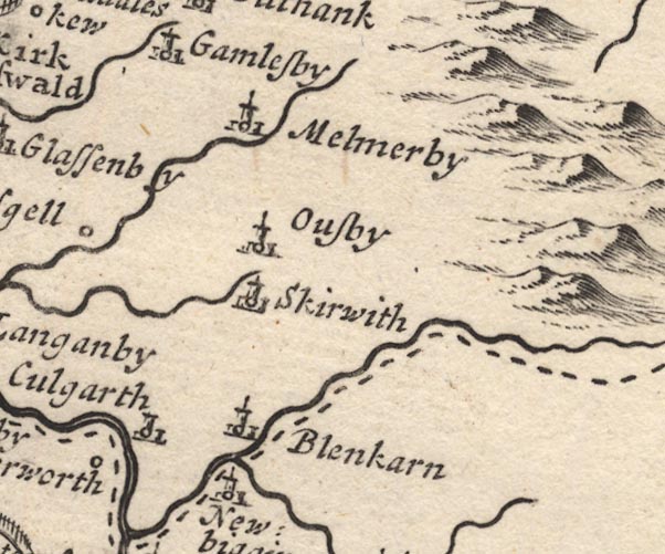
Blencarn -- building/s -- NY6331
-- 'Blenkarn' -- Circle, building and tower.
Culgaith -- building/s -- NY6129 -- 'Culgarth' -- Circle, building and tower. Melmerby -- building/s -- NY6137 -- 'Melmerby' -- Circle, building and tower. Milburn Beck -- river -- NY6528 (etc) -- Running into the Crowdundle. Newbiggin -- building/s -- NY6228 -- 'Newbiggin' -- Circle, building and tower. Ousby -- building/s -- NY6234 -- 'Ousby' -- Circle, building and tower. Skirwith -- building/s -- NY6132 -- 'Skirwith' -- Circle, building and tower. | |
 MD12NY73.jpg
 |
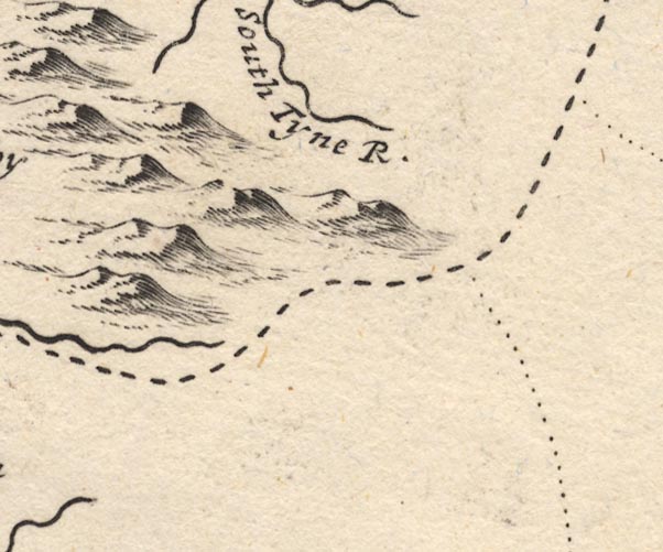
South Tyne, River -- river -- NY7441 (etc) ?
-- 'South Tyne R.'
| |
 MD12NX92.jpg
 | ||
 MD12NY02.jpg
 |
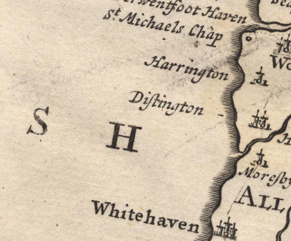
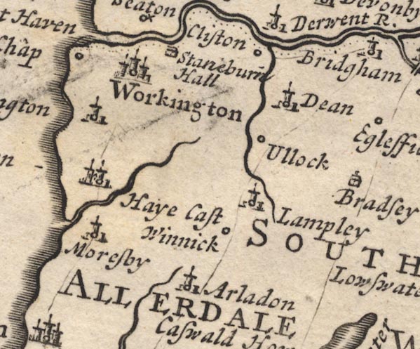
Allerdale above Derwent Ward -- ward
-- 'SOUTH ALLERDALE WARD' -- Labelling a large area.
Arlecdon -- building/s -- NY0419 -- 'Arladon' -- Circle, building and tower. Dean -- building/s -- NY0725 -- 'Dean' -- Circle, building and tower. Distington -- building/s -- NY0023 -- 'Distington' -- Circle, building and tower, sharing its symbol with Haye Castle. Great Clifton -- building/s -- NY0429 ? ? -- 'Cliston' -- Circle. Harrington -- building/s -- NX9825 -- 'Harrington' -- Circle, building and tower. Hayes Castle -- castle -- NX9922 ? -- 'Haye Cast' -- Circle, building with two towers, sharing a symbol with Distington. Lamplugh -- building/s -- NY088207 -- 'Lampley' -- Circle, building and tower. Lowca Beck -- river -- NX978212 -- Running into the sea by Moresby. Marron, River -- river -- NY0624 -- Running by Ullock and into the Derwent. Moresby -- building/s -- NX9921 -- 'Moresby' -- Circle, building and tower. Cockermouth to Whitehaven -- route -- road -- NY13 -- Single line. Egremont to Cockermouth -- road -- route -- NY01 -- Single line, route via Eaglesfield; another single line, route via Arlecdon. St Michael's Church -- church -- NX99722894 ? -- 'St. Michaels Chap' -- Circle. Stainburn -- building/s -- NY0229 ? -- 'Staneburn Hall' -- Drawing of a house. Ullock -- building/s -- NY0723 -- 'Ullock' -- Circle. Whinnah -- building/s -- NY0720 -- 'Winnick' -- Circle. Workington -- building/s -- NX996288 -- 'Workington' -- Circle, buildings, towers. | |
 MD12NY12.jpg
 |
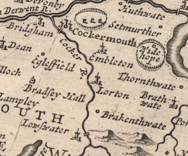
Brackenthwaite -- building/s -- NY154221
-- 'Brakenthwate' -- Circle.
Brigham -- building/s -- NY0830 -- 'Bridgham' -- Circle, building and tower. Cocker Bridge -- bridge -- NY12233071 -- Double line over the Cocker at Cockermouth. Cocker, River -- river -- NY1426 ? -- 'Cocker R.' Cockermouth -- building/s etc -- NY122306 -- 'Cockermouth' -- Circle, buildings, towers. Eaglesfield -- building/s -- NY0928 -- 'Eglesfield' -- Circle. Embleton -- building/s -- NY1730 -- 'Embleton' -- Circle, building and tower. High Lorton -- building/s -- NY162257 -- 'Lorton' -- Circle, building and tower. Low Lorton -- building/s -- NY152259 ? -- 'Lorton' -- Circle, building and tower. Loweswater -- building/s -- NY139208 -- 'Lowswater' -- Circle, building and tower. Pardshaw Hall -- building/s -- NY10272536 ? ? -- 'Bradsey Hall' -- Drawing of a house. park, Cockermouth -- park -- NY1331 -- Ring of fence palings, trees, by Cockermouth. Cockermouth to Whitehaven -- route -- road -- NY13 -- Single line. Egremont to Cockermouth -- road -- route -- NY01 -- Single line, route via Eaglesfield; another single line, route via Arlecdon. Keswick to Cockermouth -- road -- route -- NY22 -- Single line. Scalehill Bridge -- bridge -- NY148215 -- Double line over the Cocker, near Loweswater. Wythop -- locality -- NY203284 (etc) -- 'Widehope' -- Circle, in a park. Wythop Park (?) -- park -- NY203284 -- Ring of fence palings, trees, inclosing Wythop. | |
 MD12NY22.jpg
 |
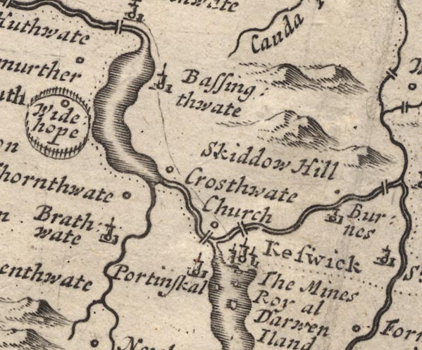
Bassenthwaite -- building/s -- NY2332
-- 'Bassingthwate' -- Circle, building and tower.
Bassenthwaite Lake -- lake -- NY215298 -- Outline with shore shading. Braithwaite -- building/s -- NY231235 -- 'Brathwate' -- Circle, building and tower. Burns Farm -- building/s -- NY308242 -- 'Burnes' -- Circle, building and tower. Derwent Isle -- island -- NY261224 -- 'Darwen Iland' -- Island. Derwent Water -- lake etc -- NY260210 ? -- Outline with shore shading. Great Crosthwaite -- building/s etc -- NY261242 -- 'Crosthwate Church' -- Circle. Greta Bridge -- bridge -- NY26302374 ? ? -- Double line over the Greta at Keswick. Greta, River -- river -- NY2924 Keskadale Beck -- river -- NY2119 ? -- Running into Newlands Beck. Keswick -- building/s etc -- NY266234 -- 'Keswick' -- Circle, buildings, towers. Keswick Smelting House -- smelting house -- mine (associated) -- NY280238 (approx) -- 'The Mines Royal' -- No symbol, at Keswick. Little Crosthwaite -- building/s -- NY234276 -- Circle, perhaps sharing a label with Crosthwaite? Long Bridge -- footbridge -- bridge -- NY25362377 -- Double line over the Derwent, below Keswick. Newlands Beck -- river -- NY2319 -- Running into Bassenthwaite Lake. Portinscale -- building/s -- NY251235 -- 'Portinskal' -- Circle, building and tower. Setmurthy -- locality -- NY1832 -- 'Setmurther' -- Circle. Skiddaw -- hill -- NY260290 -- 'Skiddow Hill' -- Hillock, a little larger. Thornthwaite -- building/s -- NY223254 ? -- 'Thornthwate' -- Circle. | |
 MD12NY32.jpg
 |
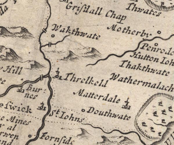
Dowthwaitehead -- building/s -- NY370208 ?
-- 'Douthwate' -- Circle.
ford, Wallthwaite -- ford -- NY35342620 ? ? -- Double line over the Mosedale Beck, near Wakthwate (Wallthwaite). Lamb Bridge -- bridge -- NY35372676 -- Double line over the Glenderamakin, near Wakthwate (Wallthwaite). Matterdale -- locality -- NY3922 (?) -- 'Matterdale' -- Circle, building and tower. Mosedale Beck -- river -- NY3523 -- Running into the Greta south of Wakthwate. St John's Beck -- river -- NY3123 ? Threlkeld -- building/s -- NY322254 -- 'Threlkeld' -- Circle, building and tower. Threlkeld Bridge -- bridge -- NY31472470 -- Double line over a stream, near Threlkeld. Wallthwaite -- building/s -- NY353262 -- 'Wakthwate' -- Circle. | |
 MD12NY42.jpg
 |
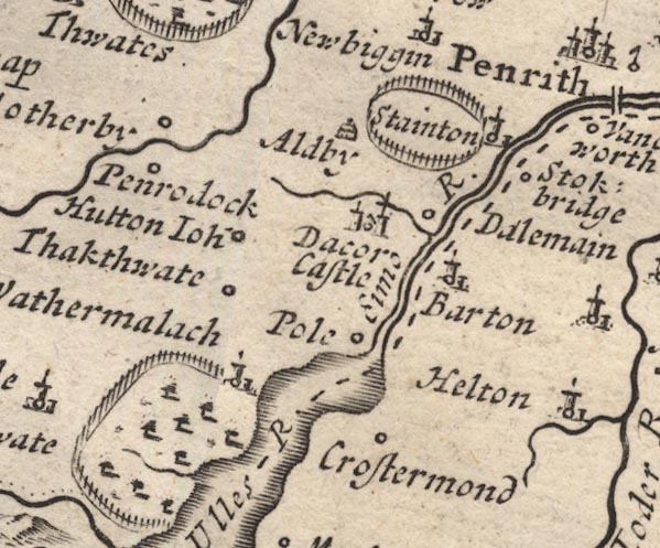
Aldby -- building/s -- NY461277
-- 'Aldby' -- Drawing of a house.
Barton -- building/s -- NY486264 -- 'Barton' -- Circle, building and tower. Cross Dormont -- building/s -- NY46182250 -- 'Crostermond' -- Circle. Dacre Beck -- river -- NY4626 -- Running by Dacre and into the Eamont. Dacre Castle -- castle -- NY46052650 -- 'Dacor Castle' -- Circle, building with two towers, and a cross on one tower. Dalemain -- park -- house -- museum -- NY479269 -- 'Dalemain' -- Circle; ring of fence palings, N of the circle. Eamont, River -- river etc -- NY469243 (from) ? ? -- '[Eimo] R.' Gowbarrow Park -- park -- NY408212 (etc) -- Ring of fence palings, trees. Hutton John -- park -- house -- tower -- peel -- NY43972696 -- 'Hutton Ioh~' -- Circle. Motherby -- building/s -- NY4228 -- 'Motherby' -- Circle. Penruddock -- building/s -- NY429276 -- 'Penrodock' -- Circle. Pooley Bridge -- building/s etc -- NY472244 -- 'Pole' -- Circle. Sockbridge -- building/s -- NY4926 -- 'Stokbridge' -- Circle. Stainton -- building/s -- NY4827 -- 'Stainton' -- Circle, building and tower, on the edge of a park. Thackthwaite -- building/s -- NY423254 -- 'Thakthwate' -- Circle. Ullswater -- lake -- NY422202 (etc) ? -- 'Ulles R.' -- Outline with shore shading. Watermillock -- building/s -- NY445224 -- 'Wathermalach' -- Circle, building and tower, on edge of Gowbarrow Park. | |
 MD12NY52.jpg
 |
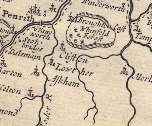
Askham -- building/s -- NY513237
-- 'Askham' -- Circle, building and tower.
Brougham Castle -- castle -- NY537290 ? -- 'Broughton Cast' -- Circle, building with two towers, by its park. Clifton -- building/s -- NY534266 -- 'Clifton' -- Circle, building and tower. Eamont Bridge bridge -- bridge -- NY52202875 -- Double line over a stream. Helton -- building/s -- NY510220 -- 'Helton' -- Circle, building and tower. Heltondale Beck -- river -- NY51522025 ? -- Running into the Lowther south of Helton. Leith, River -- river -- NY5523 -- Running by the Stricklands and into the Lyvennet. Lowther -- building/s -- NY536236 -- 'Lowther' -- Circle, building and tower. Lowther, River -- river etc -- NY5124 (etc) ? -- 'Ioder R' Morland -- building/s -- NY598225 -- 'Morlan' -- Circle, building and tower. Penrith -- building/s etc -- NY513304 -- 'Penrith' -- Circle, buildings, towers. Penrith Castle -- castle -- NY51272993 -- Circle, with a flag? Whinfell Forest -- forest -- wood -- NY5727 (etc) -- 'Whinfeld Forest' -- Trees in the park. Whinfell Park -- building/s -- NY5528 -- Ring of fence palings, trees. Yanwath -- building/s -- NY5127 -- 'Vaneworth' -- Circle. | |
 MD12NY62.jpg
 |
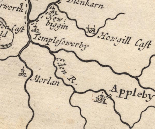
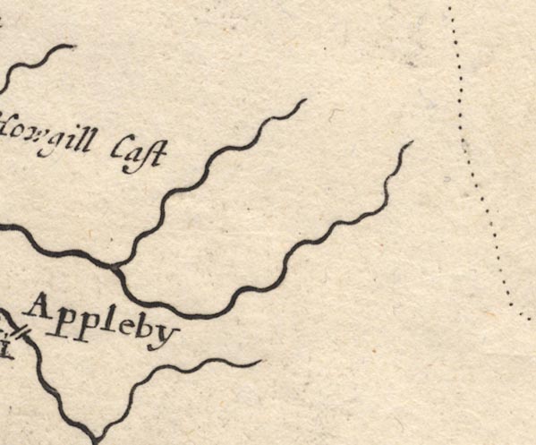
Appleby-in-Westmorland -- building/s etc -- NY684204
-- 'Appleby' -- Circle, buildings, towers.
bridge, Appleby-in-Westmorland -- bridge -- NY68432043 -- Double line over the Eden, at Appleby. Crowdundle Beck -- river -- NY6228 (etc) -- Running into the Eden north of Templesowerby. Eden, River -- river etc -- NY3658 (etc) -- 'Eden R.' Hoff Beck -- river -- NY6717 (etc) -- Running into the Eden below Appleby. Howgill Castle -- building/s -- NY665292 -- 'Howgill Cast' -- Circle, building with two towers. Temple Sowerby -- building/s -- NY6127 -- 'Templesowerby' -- Circle, building and tower. Trout Beck -- river -- boundary -- NY6624 (etc) -- Running into the Eden south of Templesowerby. | |
 MD12NY72.jpg
 | ||
 MD12NX91.jpg
 |
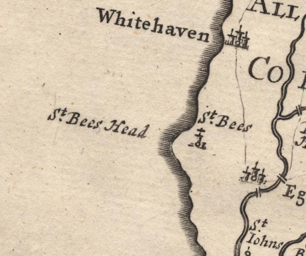
Cockermouth to Whitehaven -- route -- road -- NY13
-- Single line.
Egremont to Whitehaven -- route -- road -- NY01 -- Single line. St Bees -- building/s -- NX971116 -- 'St. Bees' -- Circle, building and tower. St Bees Head -- headland -- NX9412 -- 'St. Bees Head' -- Headland. Whitehaven -- building/s -- NX974182 -- 'Whitehaven' -- Circle, buildings, towers. | |
 MD12NY01.jpg
 |
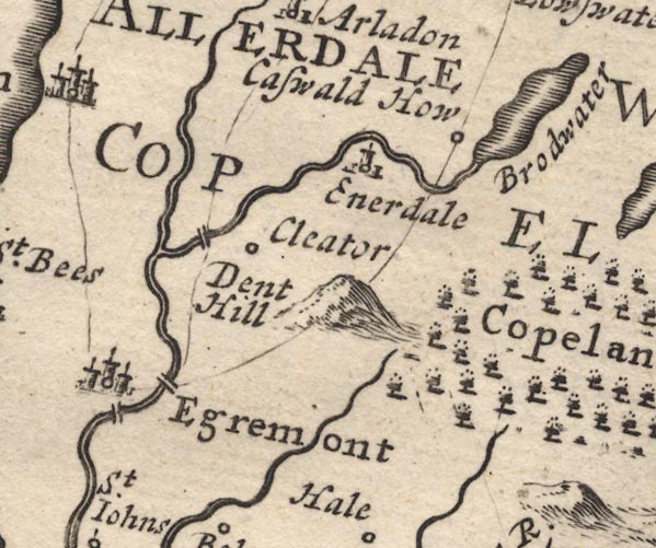
Blackhow Bridge -- bridge -- NY016134
-- Double line over a stream, near Dent Hill.
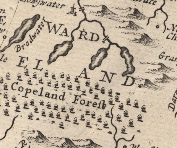
Briscoemill Bridge -- bridge -- NY015116 ? ? -- Double line over the Ehen, at Egremont. Cleator -- building/s -- NY0113 -- 'Cleator' -- Circle. Copeland -- locality -- NY10 (etc) -- 'COPELAND' -- Area. Dent -- NY0313 -- 'Dent Hill' -- Hillock. Egremont -- building/s -- NY011105 -- 'Egremont' -- Circle, buildings, towers. Ennerdale Bridge -- building/s -- NY069159 -- 'Enerdale' -- Circle, building and tower. Ennerdale Water -- lake -- NY106150 -- 'Brodwater' -- Outline with shore shading. How Hall Farm -- building/s -- NY09021635 -- 'Caswald How' -- Circle. Keekle, River -- river -- NY0019 (etc) -- Running into the Ehen above Egremont. Old Bridge (?) -- bridge -- NY010104 -- Double line over the Ehen, at Egremont. Egremont to Cockermouth -- road -- route -- NY01 -- Single line, route via Eaglesfield; another single line, route via Arlecdon. | |
 MD12NY11.jpg
 |
Bleaberry Tarn -- lake -- NY165154 ? ?
-- Outline with shore shading.
Buttermere -- lake -- NY182158 -- Outline with shore shading. Cocker, River -- river -- NY1426 ? -- Cocker River Copeland Forest -- forest -- NY10 (etc) -- 'Copeland Forest' -- Trees. Loweswater -- lake -- NY125217 ? -- Outline with shore shading. Park Beck -- river -- NY15162056 -- Running into the Cocker above Loweswater. Scale Bridge -- bridge -- NY16801659 ? -- Double line over a stream. | |
 MD12NY21.jpg
 |
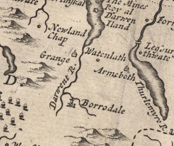
Armboth -- locality -- NY305171
-- 'Armeboth' -- Drawing of a house.
Borrowdale -- locality -- valley -- NY2516 (etc) -- 'Borrodale' -- Circle, building and tower. Derwent Water -- lake etc -- NY260210 ? -- Outline with shore shading. Derwent, River -- river etc -- NY2515 (etc) ? -- 'Darwent R.' Grange -- building/s -- NY252174 -- 'Grange' -- Drawing of a house. High Bridge (?) -- bridge -- NY31541956 (?) -- Double line over a stream, near Legburthwate. Legburthwaite -- building/s -- NY319193 -- 'Legburgthwate' -- Circle. Newlands Church -- chapel -- church -- school (ex) -- NY22981934 -- 'Newland Chap' -- Circle. Newlands -- building/s -- NY234204 (approx) ? -- 'Newland Chap' -- Circle. Stonethwaite Beck -- river -- NY2614 -- Running into the Derwent in Borrowdale. Watendlath -- building/s -- NY276163 -- 'Watenlath' -- Circle. | |
 MD12NY31.jpg
 |
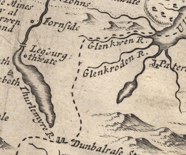
Aira Beck -- river -- NY40001974
-- Running by the edge of Gowbarrow Park and into Ullswater.
Fornside -- building/s -- NY320206 -- 'Fornside' -- Circle. Glencoyne Beck -- river -- NY38751881 ? -- 'Glenkwen R.' -- With the county boundary alongside. Glenridding Beck -- river -- NY35971603 ? -- 'Glenkroden R.' Grisedale Tarn -- lake -- NY348120 ? -- Outline with shore shading. Thirlmere -- lake -- NY3115 (etc) ? -- 'Thurlemyre R' -- Outline with shore shading. | |
 MD12NY41.jpg
 |
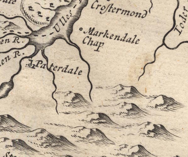
Goldrill Beck -- river -- NY393166
-- Running into Ullswater from the south.
Grisedale Beck -- river -- NY36451437 ? -- From Grisedale Tarn into Ullswater by Patterdale. Howegrain Beck -- river -- NY44321990 ? -- Running into Ullswater to the south of Markendale Chap. Patterdale -- building/s -- NY394160 -- 'Paterdale' -- Circle, building and tower. St Martin's Church -- church -- NY43421840 -- 'Markendale Chap' -- Circle. Ullswater -- lake -- NY422202 (etc) ? -- Ulles River -- Outline with shore shading. | |
 MD12NY51.jpg
 | ||
 MD12NX90.jpg
 |
Ehen, River -- river -- NY0515 (etc) ?
-- Running from Ennerdale Water to sea.
St John's Church -- church -- NY01870671 -- 'St. Iohns [Bekermet]' -- Circle. | |
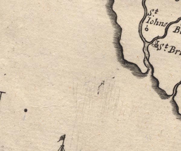
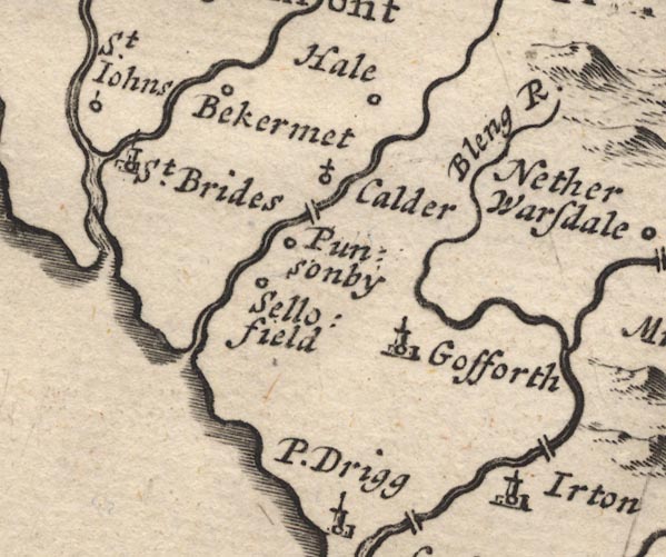 MD12NY00.jpg
 |
Bleng, River -- river -- NY1108
-- 'Bleng R.'
Calder Abbey -- abbey -- religious house -- NY05200647 -- 'Calder' -- Circle, with a cross. Calder Bridge -- bridge -- NY042059 ? -- Double line over the stream, below Calder Abbey. Calder, River -- river etc -- NY0712 (etc) ? -- Running by Calder Abbey and into the sea. Gosforth -- building/s -- NY070035 -- 'Gosforth' -- Circle, building and tower. Haile -- building/s -- NY0308 -- 'Bekermet' -- 'Hale' -- Circle. -- Circle, at the east of the label. Hale -- building/s -- NY00 -- 'Hale' -- Circle, at the east of the label. Irton -- locality -- NY1000 -- 'Irton' -- Circle, building and tower. Kirk Beck -- river -- NY0106 (?) -- Running into the Ehen near St Brides. Ponsonby -- building/s -- NY054055 -- 'Punsonby' -- Circle. Santon Bridge (?) -- bridge -- NY11020161 -- Double line over a stream, near Irton. Sellafield (?) -- locality -- NY0203 -- 'Sellofield' -- Circle. St Bridget's Church -- church -- NY01480608 ? -- 'St. Brides' -- Circle, building and tower. | |
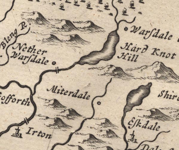 MD12NY10.jpg
 |
Burnmoor Tarn -- lake -- NY183043 ?
-- Outline with shore shading.
Forest Bridge -- bridge -- NY12840375 ? ? -- Double line over a stream, at Nether Wasdale. Miterdale -- valley -- NY1501 -- 'Miterdale' -- Circle. Nether Wasdale -- locality -- NY1204 (etc) -- 'Nether Warsdale' -- Circle. St Olaf's Church -- church -- NY18850869 -- 'Warsdale Chap' -- Circle. Wast Water -- lake -- NY161059 -- Outline with shore shading. | |
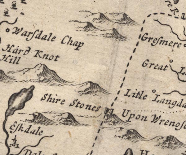 MD12NY20.jpg
 |
Hard Knott -- hill -- NY23180237
-- 'Hard Knot Hill' -- Large hillock.
Little Langdale -- building/s -- NY315034 -- 'Litle Langdale' -- Circle. Three Shire Stones -- boundary stone -- stone -- NY27720274 ? -- 'Shire Stones Upon Wrenose' -- Two upright stones. | |
 MD12NY30.jpg
 |
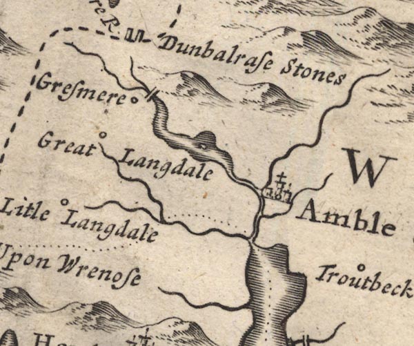
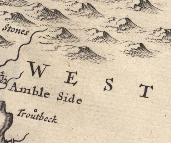
Ambleside -- building/s etc -- NY376045 ?
-- 'Amble Side' -- Circle, buildings, towers, with a cross.
Church Bridge -- bridge -- NY33740735 -- Double line over a stream, at Grasmere. Grasmere -- building/s -- NY336075 ? -- 'Gresmere' -- Circle. Grasmere -- lake -- NY337066 -- Outline with shore shading, single area for two lakes, between Grasmere and Ambleside, with an island. Great Langdale -- building/s -- NY3006 (?) -- 'Great Langdale' -- Circle. Heron Island -- island -- NY356062 ? ? -- In Rydal Water. Rydal Water -- lake -- NY355061 -- Outline with shore shading, single area for two lakes, between Grasmere and Ambleside, with an island. Windermere -- lake -- SD392950 ? -- Wynandermere -- Outline with shore shading, the boundary running through the lake from the Rothay/Brathay to about Fellfoot? | |
 MD12NY40.jpg
 |
Troutbeck -- building/s -- NY4103
-- 'Troutbeck' -- Circle.
| |
 MD12SD09.jpg
 |
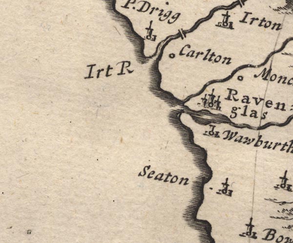
Carleton Hall -- building/s -- SD082987
-- 'Carlton' -- Circle.
Drigg -- building/s -- SD0698 -- 'P. Drigg' -- Circle, building and tower. Holme Bridge, Drigg and Carleton -- bridge -- SD07709872 -- Double line over a stream, over the Irt. Irt, River -- river etc -- NY1002 (etc) ? -- 'Irt R' -- River mouth. Mite, River -- river etc -- NY1602 -- Running from Miterdale to the sea. Muncaster Castle -- castle -- museum -- SD103964 ? -- 'Moncaster' -- Circle. Ravenglass -- building/s etc -- SD085964 -- 'Ravenglas' -- Circle, buildings, towers. Seaton Hall -- building/s -- priory (ex) -- religious house (ex) -- SD107899 -- 'Seaton' -- Circle, building and tower. Waberthwaite -- building/s -- SD104935 -- 'Wawburthwate' -- Circle, building and tower. | |
 MD12SD19.jpg
 |
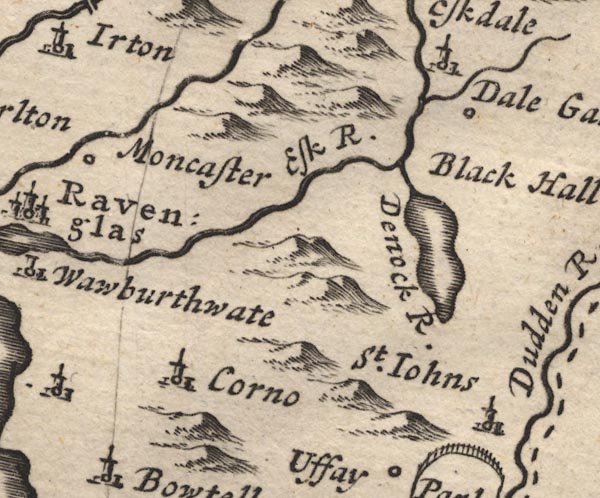
Corney -- building/s -- SD115914 ?
-- 'Corno' -- Circle, building and tower.
Dalegarth Hall -- building/s -- NY169001 ? -- 'Dale Garth' -- Circle. Devoke Water -- lake -- SD158969 -- 'Denock R.' -- Outline with shore shading. Esk, River -- river etc -- NY2101 (etc) ? -- 'Esk R.' Eskdale Green -- building/s -- NY141001 -- 'Eskdale' -- Circle, building and tower. Linbeck Gill -- river -- SD1497 -- From Devoke Water. St John's Church -- church -- SD19799325 -- 'St. Iohns' -- Circle, building and tower. Ulpha -- building/s -- SD197932 (etc) -- 'St. Iohns' -- Circle, building and tower. Whillan Beck -- river -- NY1803 -- Running from Burnmoor Tarn into the Esk. | |
 MD12SD29.jpg
 |
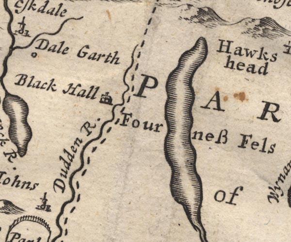
Black Hall -- building/s -- NY23920120 ?
-- 'Black Hall' -- Drawing of a house.
Coniston Water -- lake -- SD302943 -- Outline with shore shading. Duddon, River -- river etc -- NY2602 (etc) -- 'Duddon R.' -- With the county boundary drawn alongside. Furness Fells -- hill -- fell -- SD3389 (etc) -- 'Fourness Fels' -- Area, no symbol. | |
 MD12SD39.jpg
 |
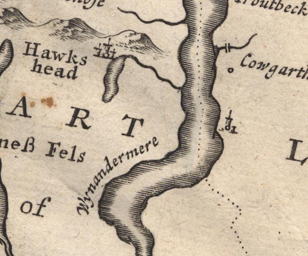
Bowness-on-Windermere -- building/s -- NY403969 ? ?
-- Circle, building and tower.
Calgarth Hall -- building/s -- SD398996 ? -- 'Cowgarth' -- Circle. Esthwaite Water -- lake -- SD3696 (etc) -- Outline with shore shading. Hawkshead -- building/s etc -- SD351980 -- 'Hawkshead' -- Circle, buildings, towers. Troutbeck Bridge -- bridge -- NY40310035 -- Double line over a stream. Windermere -- lake -- SD392950 ? -- 'Wynandermere' -- Outline with shore shading, the boundary running through the lake from the Rothay/Brathay to about Fellfoot? | |
 MD12SD49.jpg
 | ||
 MD12SD08.jpg
 |
Whitbeck -- building/s -- SD118845
-- 'Whidbeck' -- Circle, building and tower.
| |
 MD12SD18.jpg
 |
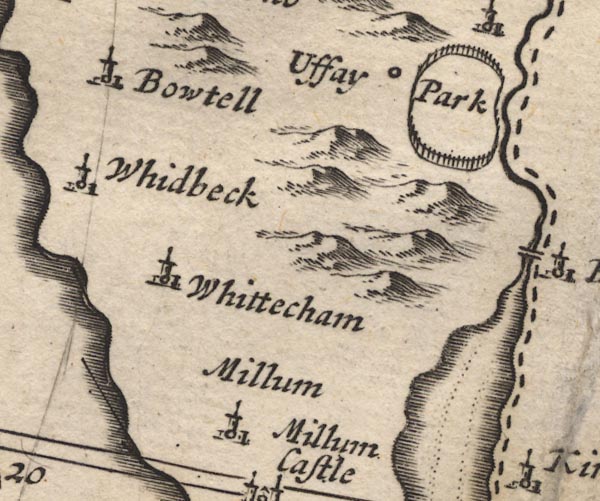
Bootle -- building/s etc -- SD108883
-- 'Bowtell' -- Circle, building and tower.
Duddon Estuary -- estuary -- river estuary etc -- SD1475 (etc) -- Foreshore sands outlined by dotted line. -- The county boundary drawn down the east shore. Millom -- building/s -- SD171801 -- 'Millum' -- Circle, building and tower. Ulpha Park -- park -- SD187911 (etc) -- 'Uffay Park' -- Circle, and ring of fence palings, no trees. Whicham -- building/s -- SD132825 -- 'Whittecham' -- Circle, building and tower. | |
 MD12SD28.jpg
 |
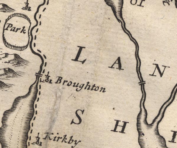
Broughton in Furness -- building/s etc -- SD211876
-- 'Broughton' -- Circle, building and tower.
Duddon Bridge -- bridge -- SD19928818 -- Double line over a stream, at Broughton. Spark Bridge -- bridge -- SD30668489 ? -- Double line over a stream, over the Crake? | |
 MD12SD38.jpg
 |
Newby Bridge -- bridge -- SD36918636 ?
-- 'Newbridge' -- Double line over a stream.
| |
 MD12SD17.jpg
 |
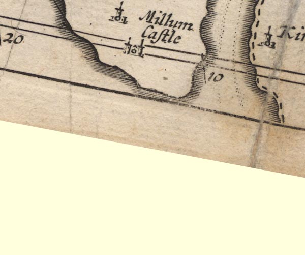
Duddon Estuary -- estuary -- river estuary etc -- SD1475
(etc)
-- Foreshore sands outlined by dotted line. -- The county
boundary drawn down the east shore.
Millom Castle -- castle -- SD171813 -- 'Millum Castle' -- Circle, building with two towers. | |
 MD12SD27.jpg
 |
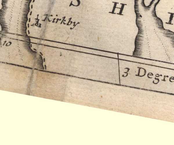
Kirkby -- SD2484 (area)
-- 'Kirkby' -- Circle, building and tower.
| |
 MD12SD37.jpg
 |
Leven Estuary -- estuary -- river estuary -- sea area --
SD3375 (etc)
-- Foreshore sands outlined by dotted line.
| |
 Lakes Guides menu.