 Morden 1695
 |
 |
|
|
Places Identified
Map, hand coloured engraving, Westmorland, scale about 2.5 miles to 1 inch, by Robert Morden, 1695. NB: each image includes an overlap, places in the overlap are not listed. The images are roughly equivalent to ngr 10Km squares and are listed from top left to bottom right. | ||
 MD10NY43.jpg
 | ||
 MD10NY53.jpg
 |
Eamont, River -- river etc -- NY469243 (from) ? ?
-- Emie Flu -- With the county boundary drawn alongside.
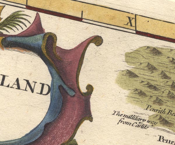
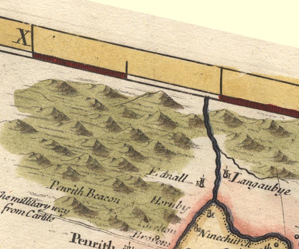
Edenhall -- building/s -- NY565324 -- 'Ednall' -- Circle, building and tower. Hornby Hall -- building/s -- NY5629 ? ? -- 'Hornby' -- Circle, building and tower. Langwathby -- building/s -- NY5633 -- 'Langaubye' -- Circle, building and tower. Penrith Beacon -- beacon -- NY52123138 -- 'Penrith Beacon' -- On a hillock, post, ladder and cresset?. Penrith to Carlisle -- route -- road -- NY53 ? -- 'The millitary way from Carlile' -- Double line. | |
 MD10NY63.jpg
 |
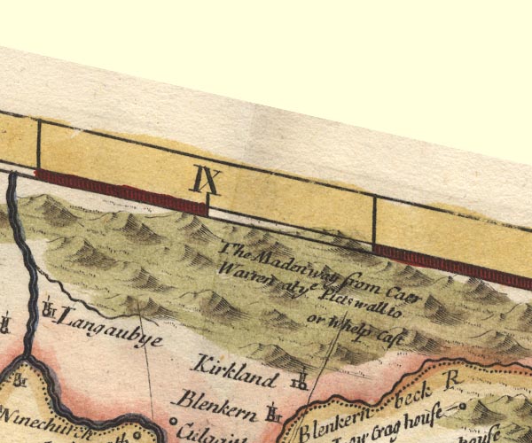
Kirkland -- building/s -- NY646325
-- 'Kirkland' -- Circle, building and tower.
Maiden Way -- roman road -- roman site -- NY6538 (etc etc) -- 'The Maden way from Caer Warren at ye Picts wall to or Whelp Cast' -- Double line. | |
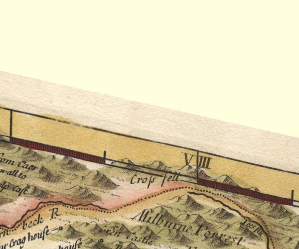 MD10NY73.jpg
 |
Cross Fell -- hill -- NY6834
-- 'Cross fell' -- Hillocks.
| |
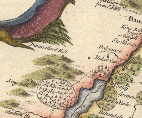 MD10NY42.jpg
 |
Aira Beck -- river -- NY40001974
-- 'Arey beck'
Barton Park -- park -- NY468223 (etc) -- 'Barton Park' -- Ring of fence palings, trees. Cross Dormont -- building/s -- NY46182250 -- 'Trostermont' -- Circle and tower, within Barton Park. Dacre Castle -- castle -- NY46052650 -- 'Daker Castl.' -- Circle and tower. Dunmallard Hill -- hill -- NY468246 -- 'Dunmallard Hill' -- Hillock, the label is misplaced. Gowbarrow Park -- park -- NY408212 (etc) -- 'Gowburrow park' -- Ring of fence palings, trees, stream, road and circle for a place. Pooley Bridge -- building/s etc -- NY472244 -- 'Pooley' -- Circle, building and tower. Ullswater -- lake -- NY422202 (etc) ? -- Ulles Flu -- Outline with shore shading, tinted blue; the county boundary drawn in the lake from Glencoin to Pooley Bridge. | |
 MD10NY52.jpg
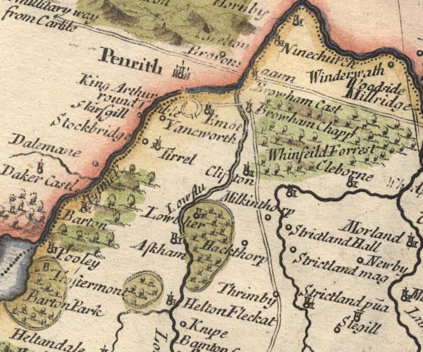
 |
Arthur's Round Table -- henge -- NY523284
-- 'King Arthur round Table' -- Double circle with entrances
into the earthwork.
Askham -- building/s -- NY513237 -- 'Askham' -- Circle, building and tower. Askham Bridge -- bridge -- NY51842394 -- Double line over the stream. Barton -- building/s -- NY486264 -- Circle, building and tower. Brougham Castle -- castle -- NY537290 ? -- 'Browham Cast / Br[o]voniacum' -- Tower. Carleton -- building/s -- NY5329 -- 'Carelton' -- Circle. Cliburn -- building/s -- NY5824 -- 'Cleborn' -- Circle, building and tower. Clifton -- building/s -- NY534266 -- 'Clifton' -- Circle, building and tower. Dalemain -- park -- house -- museum -- NY479269 -- 'Dalemane' -- Circle. Eamont Bridge bridge -- bridge -- NY52202875 -- Double line over a stream. Eamont Bridge -- building/s -- NY5228 -- 'Emot' -- Circle, building and tower. Eamont, River -- river etc -- NY469243 (from) ? ? -- 'Em[ie fl]' -- With the county boundary drawn alongside. Great Strickland -- building/s -- NY5522 ? -- 'Strictland mag' -- Circle. Hackthorpe -- building/s -- NY542232 -- 'Hackthorp' -- Circle. Helton -- building/s -- NY510220 -- 'Helton Fleckat' -- Circle, building and tower. Heltondale Beck -- river -- NY51522025 ? -- Runs into the Lowther near Helton. Little Strickland -- building/s -- NY5619 ? -- 'Strictland p~ua' -- Circle, building and tower. Lowther -- building/s -- NY536236 -- 'Lowther' -- Circle, building and tower. Lowther Bridge -- bridge -- NY524282 ? -- Double line over a stream. Lowther Park -- park -- NY5222 (etc) -- Ring of fence palings, trees. Lowther, River -- river etc -- NY5124 (etc) ? -- 'Low flu' Melkinthorpe -- building/s -- NY5525 -- 'Milkinthorp' -- Circle. Penrith -- building/s etc -- NY513304 -- 'Penrith' -- Circle, buildings, towers. Appleby to Penrith -- road -- NY62 -- Double line. Shap to Penrith -- route -- road -- NY51 -- Double line. Setterah Park -- building/s -- NY509210 -- Ring of fence palings, trees. Skirsgill -- building/s -- NY5028 -- 'Skirsgill' -- Circle. Sockbridge -- building/s -- NY4926 -- 'Stockbridge' -- Circle. St Ninian's Church -- church -- NY55932995 -- 'Ninechurch' -- Circle, building and tower. St Wilfrid's Chapel -- church -- NY52762839 -- 'Browham Chappl' -- Circle, building and tower. Strickland Hall (?) -- building/s -- NY5523 (guess) -- 'Strictland Hall' -- Circle. Thrimby -- building/s -- NY5520 -- 'Thrimby' -- Circle. Tirril -- building/s -- NY5026 -- 'Tirrel' -- Circle, building and tower. Whinfell Forest -- forest -- wood -- NY5727 (etc) -- 'Whinfeild Forrest' -- Trees. Yanwath -- building/s -- NY5127 -- 'Yaneworth' -- Circle. | |
 MD10NY62.jpg
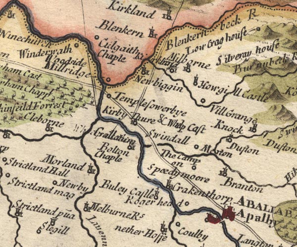
 |
All Saints Church -- church -- NY639233
-- 'Bolton Chaple' -- Circle, building and tower.
All Saints Church -- church -- NY61022966 -- 'Culgaith Chaple' -- Circle. Appleby-in-Westmorland -- building/s etc -- NY684204 -- 'Apalby / ABALLABA' -- Circle, buildings, towers on the road north of the river, and circle, building and tower south of the river. Bewley Castle -- castle (remains) -- NY64822115 -- 'Buley Castle' -- Circle, tower with a flag. Blencarn -- building/s -- NY6331 -- Circle, building and tower. Brampton Beck -- river -- NY675241 -- Joining the Swindale Beck near Merton. Brampton -- building/s -- NY6723 -- 'Branton' -- Circle, building and tower. bridge, Appleby-in-Westmorland -- bridge -- NY68432043 -- Double line over a stream. bridge, Kirkby Thore -- bridge -- NY635252 -- Note that the river is the Trout Beck, the Swindale Beck is a headwater. Colby Beck -- river -- NY664212 Crackenthorpe -- building/s -- NY661221 ? -- 'Crakenthorp' -- Circle, building and tower. Crowdundle Beck -- river -- NY6228 (etc) -- 'Blenkern beck R' -- With the county boundary drawn alongside; the river is muddled with a minor stream that starts near it but diverges away. Dufton -- building/s -- NY6825 -- 'Dufton' -- Circle, building and tower. Eden Bridge -- bridge -- NY60392818 -- Double line over a stream. Eden, River -- river etc -- NY3658 (etc) -- Eden River -- With the county boundary drawn alongside. Howgill Castle -- building/s -- NY665292 -- 'Howgill Castle' -- Circle, tower. King's Meaburn -- building/s -- NY6221 ? -- 'Melburne Rs' -- Circle, building and tower. Kirkby Thore -- building/s -- NY638256 -- 'Kirby Thure & Whelp Cast / Galla[tum]' -- Circle, building and tower; the roman name is engraved over a poorly erased label for Whelp Castle. Leith, River -- river -- NY5523 -- Joining the Lyvennet. Long Marton -- building/s -- NY6624 ? -- 'Merton' -- Circle. Milburn -- building/s -- NY6529 -- 'Milborne' -- Circle, building and tower. Milburn Grange -- building/s -- NY671280 ? -- 'Vill Grange' -- Circle. Millrigg -- building/s -- NY607283 -- 'Millridge' -- Circle. Morland -- building/s -- NY598225 -- 'Morland' -- Circle, building and tower. Newbiggin -- building/s -- NY6228 -- 'Newbiggin' -- Circle, building and tower. Newby -- building/s -- NY5921 -- 'Newby' -- Circle. Appleby to Bowes -- route -- road etc -- NY62 -- Double line. Appleby to Penrith -- road -- NY62 -- Double line. Bowes to Appleby -- route -- road etc -- NY62 -- Double line. Roger Head -- building/s -- NY669219 -- 'Roger head' -- Circle. Camp on Speedy Moor, The -- roman fort -- roman site -- NY647237 ? ? -- 'The Camp on Speedymoore' -- Circle. Sleagill -- building/s -- NY5919 -- 'Slegill' -- Circle, tower. Temple Sowerby -- building/s -- NY6127 -- 'Templesowerbye' -- Circle. Trout Beck -- river -- boundary -- NY6624 (etc) -- 'Swindall' -- No symbol; the label seems to be for the valley SE of Kikby Thore, where the Trout Beck runs; one of the headwaters of this stream is the Swindale Beck. Winderwath -- building/s -- NY597294 -- 'Winderwath' -- Circle. Woodside -- building/s -- NY585292 ? -- 'Woodside' -- No symbol. | |
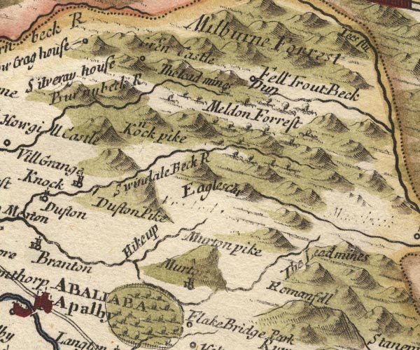 MD10NY72.jpg
 |
Dufton Fell -- hill -- fell -- NY7529 (etc) ?
-- 'Meldon Forrest' -- Trees.
Dufton Pike -- hill -- NY699266 -- 'Dufton Pike' -- Hillock. Great Dun Fell -- hill -- NY710321 (etc) ? -- 'Fell / Dun' -- Circle. Green Castle -- hill (promontory?) -- NY7131 ? -- 'Green Castle' -- No symbol, perhaps labelling the hillocks. High Cup Gill -- river -- boundary -- NY7325 (etc etc) -- Running down the gap. High Cup Nick -- pass -- NY746262 -- 'Hikeup' -- Gap between hills. Knock Pike -- hill -- NY686282 -- 'Knock pike' -- Hillock. Knock -- building/s -- NY680270 -- 'Knock' -- Circle, building and tower. Little Dun Fell -- hill -- NY704330 ? ? -- 'Fell / Dun' -- Circle. Low Crag House (?) -- building/s -- NY63 -- 'Low Crag house' -- Circle on a hillock. Milburn Beck -- river -- NY6528 (etc) -- 'Burnybeck R' Milburn Forest -- forest -- NY7232 (etc) -- 'Milburne Forrest' -- No trees. mine, Milburn -- lead mine -- mine -- NY7131 -- 'The Lead mines' -- No symbol. mine, Murton -- mine -- NY762225 (etc) ? -- 'The Lead mines' -- lead mine -- mine -- No symbol. Murton -- building/s -- NY7221 -- 'Murton' -- Circle, building and tower. Murton Pike -- hill -- NY734231 -- 'Murton pike' -- Hillock. Nichol Chair -- hill (?) -- rocks (?) -- NY741260 (?) ? ? -- 'Eaglescar' -- Hillock or hill feature?. Roman Fell -- hill -- fell -- NY7520 -- 'Romanfell' -- Also:-. -- Hillocks. Silveray (?) -- building/s (?) -- NY63 -- 'Silveray house' -- Circle on a hillock. Swindale Beck -- river -- boundary -- NY6928 (etc) -- 'Swindale Beck R' Trout Beck -- river -- boundary -- NY7432 (etc) -- 'Trout Beck' | |
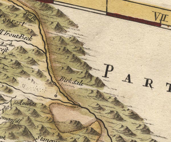 MD10NY82.jpg
 |
Birkdale -- building/s -- NY8028
-- 'Birkdale' -- Circle.
Maize Beck -- river -- boundary etc -- NY7626 (etc) -- Running into the Tees below Birkdale; there is a deleted label by this stream. Tees, River -- river -- NY7831 (etc etc) -- 'Tees flu' -- With the county boundary drawn alongside. | |
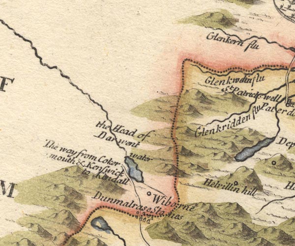 MD10NY31.jpg
 |
Derwent, River -- river etc -- NY2515 (etc) ?
-- 'the Head of Darwent water'
Glencoyne Beck -- river -- NY38751881 ? -- 'Glenkw[o]in flu' -- 'Glenkern flu' -- With county boundary drawn alongside; the same river is plotted again, and called:-. Glenridding Beck -- river -- NY35971603 ? -- 'Glenkridden flu' Helvellyn -- hill -- NY34261508 -- 'Helvillin hill' -- Marked with a circle on the side of the hillock. Ambleside to Keswick -- road -- route -- NY30 -- 'The way from Cokermouth & Kenswick to Kendall' -- Double line. Thirlmere -- lake -- NY3115 (etc) ? -- Outline, blue tint. Wythburn -- locality -- NY322130 (etc) -- 'Wiborne' -- Circle. | |
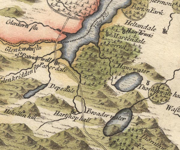 MD10NY41.jpg
 |
Brothers Water -- lake -- NY402127 ?
-- 'Broader water' -- Outline, no shore shading, not tinted,
the road running through it.
Cow Bridge -- bridge -- NY40261337 -- Double line over a stream, over the Goldrill Beck; the map is confused here, but the road has to cross this stream. Deepdale Hall -- building/s -- NY39561412 -- 'Depedale' -- Circle. Dovedale Beck -- river -- NY3811 (etc) ? -- Running into Brothers Water. Glencoyne Bridge -- bridge -- boundary -- county boundary -- NY38721879 -- Double line over a stream, over the Glenkwoin flu, on the county boundary; plotted again over the imagined Glenkern Flu. Glenridding Bridge -- bridge -- NY38711695 -- Double line over a stream, over the Glenridding Beck???. Goldrill Beck -- river -- NY393166 -- From Brothers Water to Ullswater. Grisedale Beck -- river -- NY36451437 ? -- Running into Ullswater at Patterdale. Grisedale Bridge -- bridge -- NY39041613 -- Double line over a stream, over the Grisedale Beck. Grisedale Tarn -- lake -- NY348120 ? -- Outline with shore shading, tinted blue. Hartsop Hall (?) -- building/s -- NY39861202 -- 'Hartshop hall' -- Circle, building and tower. Hawes Water -- lake -- reservoir -- NY4713 (etc) -- Outline with shore shading, tinted blue, with a hillock engraved within it. Hayeswater Gill -- river -- NY4112 Hayeswater -- lake -- NY431121 ? -- 'Hawswater' -- Outline with shore shading, tinted blue. Howtown -- building/s -- NY443195 ? -- 'Haw Towne' -- Circle, building and tower. Martindale -- locality -- NY4318 -- 'Martendale' -- Circle, building and tower. Martindale Common -- common -- NY4216 -- 'Martendale Forrest' -- Trees. Patterdale -- building/s -- NY394160 -- 'Paterdale' -- Circle, building and tower. St Patrick's Well -- spring -- NY38771663 -- 'St Patricks well' -- No symbol. Ullswater -- lake -- NY422202 (etc) ? -- 'Ulles Flu' -- Outline with shore shading, tinted blue; the county boundary drawn in the lake from Glencoin to Pooley Bridge. | |
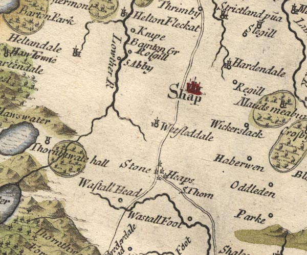 MD10NY51.jpg
 |
Bampton Grange -- building/s -- NY521180 ?
-- 'Bamton Gr' -- No symbol.
Harberwain -- building/s -- NY60731504 -- 'Haberwen' -- Circle. Hardendale -- building/s -- NY583146 -- 'Hardendale' -- Circle, building and tower. Haweswater Beck -- river -- NY5116 -- From Hawes Water, running into the Lowther. Heltondale -- building/s -- NY501208 -- 'Heltondale' -- Circle, building and tower. Stone Heaps -- stone circle -- NY568133 ? ? ? -- 'Stone Heaps' -- Group of little tower symbols around the junction of the Kendal Shap road and Shap Orton road. Knipe Hall -- building/s -- NY518194 ? -- 'Knipe' -- Circle. Lowther, River -- river etc -- NY5124 (etc) ? -- 'Lowther R' Reagill -- building/s -- NY603176 -- 'Regill' -- Circle. Kendal to Shap -- route -- road -- SD59 -- Double line. Shap to Penrith -- route -- road -- NY51 -- Double line. Rosgill -- building/s -- NY537167 -- 'Rosgill' -- Circle. Shap -- building/s etc -- NY562153 -- 'Shap' -- Circle, buildings, towers. Shap Abbey -- abbey -- religious house -- NY548153 -- 'S Abby' -- Circle. Shap Thorn -- hill -- NY571117 -- 'S. Thorn' -- No symbol, drawn beside the road from Shap towards Orton. Thornthwaite Hall -- building/s -- NY512163 -- 'Thornthwate hall' -- park -- Circle, tower; just outside a ring of fence palings, trees, with the Haweswater Beck running through. Wasdale Foot (?) -- building/s (gone?) -- NY5709 (?) -- 'Wastall Foot' -- Circle. Wasdale Head -- building/s -- NY55010817 -- 'Wastall Head' -- Circle. Wasdale Old Bridge -- bridge -- NY56470835 -- Bridge, unclear road river crossing. Wet Sleddale -- valley -- NY5411 (etc) -- 'Wetsleddale' -- Circle, building and tower. Wickerslack -- building/s -- NY608156 -- 'Wickerslack' -- Circle. | |
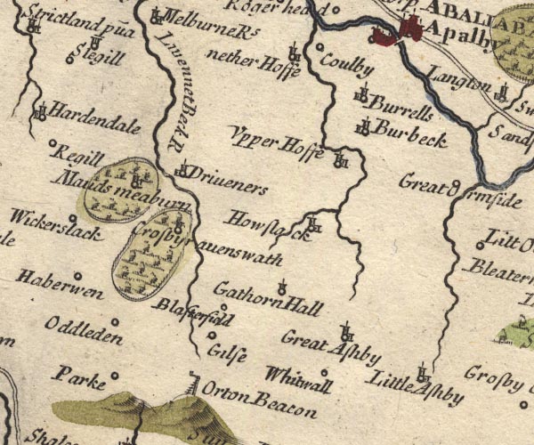 MD10NY61.jpg
 |
Beacon Hill -- hill -- beacon -- NY6309 ?
-- 'Orton Beacon' -- Post with a cresset on a bracket, and a
ladder up the side.
Blasterfield Farm -- building/s -- NY6311 ? -- 'Blas[t]erfield' -- Circle. Burbeck -- building/s -- NY6717 (?) -- 'Burbeck' -- Circle, building and tower. Burrells -- building/s -- NY6818 -- 'Burrells' -- Circle, building and tower. Colby -- building/s -- NY6620 -- 'Coulby' -- Circle. Crosby Ravensworth -- building/s -- NY622148 -- 'Crosbyravenswath' -- Circle, building and tower, in a park. Dryevers -- building/s -- NY645174 -- 'Driveners' -- Circle, building and tower. Gaythorne Hall -- building/s -- NY649132 -- 'Gathorn Hall' -- Circle, tower. Gilts -- building/s -- NY626118 ? -- 'Gilse' -- Circle. Great Asby -- building/s -- NY680131 -- 'Great Ashby' -- Circle, building and tower. Hoff -- building/s -- NY6717 -- 'Upper Hoffe' -- Circle, building and tower. Hoff Beck -- river -- NY6717 (etc) Howe Slacks -- building/s -- NY677148 -- 'Howslack' -- Circle, building and tower. Little Asby -- building/s -- NY698096 -- 'Little Ashby' -- Circle, building and tower. Lyvennet Beck -- river -- NY6215 (etc etc) -- 'Livennet Beck R' Maulds Meaburn -- building/s -- NY624168 -- 'Mauds meaburn' -- Circle, building and tower, in a park. Nether Hoff -- building/s -- NY667200 -- 'nether Hoffe' -- Circle, building and tower. Oddendale -- building/s -- NY594134 -- 'Oddleden' -- Circle. park, Crosby Ravensworth -- park -- NY6214 -- Ring of fence palings, trees, around Crosby Ravensworth. park, Maulds Meaburn -- park -- NY6216 -- Ring of fence palings, trees, around Maulds Meaburn. Park -- building/s -- NY612090 -- 'Parke' -- Circle. Scale Beck -- river -- boundary -- NY6614 (etc) -- Near Howslack. Whitewall -- building/s -- NY666124 -- 'Whitwall' -- Circle. | |
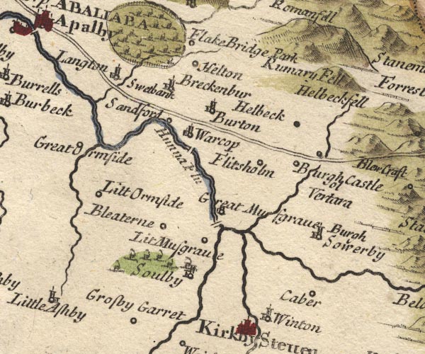 MD10NY71.jpg
 |
Bleatarn -- building/s -- NY7313
-- 'Bleaterne' -- Circle.
Brackenber -- building/s -- NY7219 -- 'Breckenbur' -- Circle, building and tower. bridge, Brough -- bridge -- NY79411417 -- Double line over the Swindale Beck at Brough. bridge, Coupland -- bridge -- NY7119 ? -- Double line over a stream, at Langton. Brough -- building/s -- NY795146 -- Circle, not labelled. Brough Castle -- castle -- NY791141 -- 'Burgh Castle ol Vertara' -- Circle. Brough Sowerby -- building/s -- NY7912 -- 'Burgh Sowerby' -- Circle, building and tower. Burton -- locality -- NY71 (?) -- 'Burton' -- Circle, building and tower. Crosby Garrett -- building/s -- NY7209 -- 'Crosby Garret' -- Circle. Eden, River -- river etc -- NY3658 (etc) -- 'Hunna Flu' -- With the county boundary drawn alongside. Flakebridge Park -- park -- NY7022 (?) -- 'Flake Bridge Park' Flitholme -- building/s -- NY761150 -- 'Flitsholm' -- Circle. Great Musgrave -- building/s -- NY767136 ? -- 'Great Musgrave' -- Circle, building and tower. Great Ormside -- building/s -- NY7017 -- 'Great Ormside' -- Circle. Helbeck -- building/s -- NY7915 -- 'Helbeck' -- Circle. Helbeck Fell -- hill -- fell -- NY814196 (etc) -- 'Helbeckfell' -- Hillock. Helm Beck -- river -- NY7015 (etc) -- Running into the Eden by Gt Ormside. Hilton Beck -- river -- NY7220 (etc) -- Running into the Eden, passing Langton. Hilton -- building/s -- NY734207 -- 'Helton' -- Circle. Kaber -- building/s -- NY7911 -- 'Caber' -- Circle. Langton -- building/s -- NY709201 -- 'Langton' -- Circle, building and tower. Little Musgrave -- building/s -- NY759131 ? -- 'Lit Musgrave' -- Circle. Little Ormside -- building/s -- NY708167 ? -- 'Litt Ormside' -- Circle. Musgrave Bridge -- bridge -- NY76571313 -- Double line over a stream, over the Eden at Gt Musgrave. Appleby to Bowes -- route -- road etc -- NY62 -- Double line. Bowes to Appleby -- route -- road etc -- NY62 -- Double line. Roman Fell -- hill -- fell -- NY7520 -- 'Rumary Fell' -- Also:-. -- Hillocks. Sandford -- building/s -- NY729162 -- 'Sandford' -- Circle. Scandal Beck -- river -- boundary -- NY7207 (etc) -- Running into the Eden at Great Musgrave; the plotting of the streams is confused. Soulby -- building/s -- NY7410 -- 'Soulby' -- Circle, building and tower. Swetbank (?) -- (?) -- NY7019 (?) -- 'Swetbank' -- No symbol. Swindale Beck -- river -- NY8016 (etc) -- Through Brough, running into the Eden. Warcop -- building/s -- NY7415 -- 'Warcop' -- Circle, building and tower. Warcop Old Bridge -- bridge -- NY74331507 -- Double line over a stream, over the Eden. | |
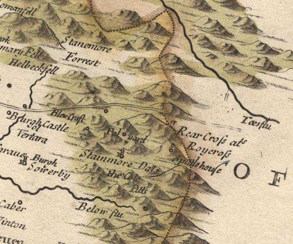 MD10NY81.jpg
 |
Belah, River -- river -- boundary etc -- NY7912 (etc)
?
-- 'Below Flu'
Bluegrass -- building/s -- NY8314 ? -- 'Blew Craft' -- Circle. mine, Kaber -- coal mine -- mine -- NY80 -- 'the Cole Pitts' -- Circle on the side of a hillock. Old Spital -- building/s -- inn -- hospital (once) -- NY910121 -- 'Spittle house' -- Circle. Palliard -- building/s -- NY864135 -- 'Pal yard' -- Circle. Rey Cross -- cross -- NY904123 ? -- 'Rear Cross als Roycross' -- Stone on the county boundary. Appleby to Bowes -- route -- road etc -- NY62 -- Double line. Bowes to Appleby -- route -- road etc -- NY62 -- Double line. Stainmore -- locality -- valley -- 'Stainmore Dale' -- Valley between hillocks. Stainmore Common -- common -- NY8517 (etc) ? ? -- 'Stanemore Forrest' -- No trees. Tees, River -- river -- NY7831 (etc etc) -- 'Tees flu' -- With the county boundary drawn alongside. | |
 MD10NY20.jpg
 | ||
 MD10NY30.jpg
 |
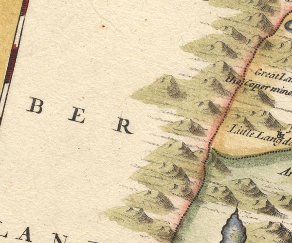
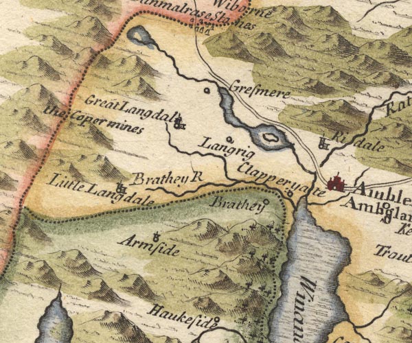
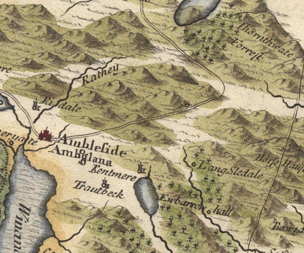
Ambleside -- building/s etc -- NY376045 ?
-- 'Ambleside / Amboglana' -- Circle, buildings, towers.
Brathay, River -- river -- NY3503 -- 'Brathey R' Clappersgate -- building/s -- NY366033 -- 'Clapperyate' -- Circle. Coniston Copper Mines -- copper mine -- mine -- SD290985 & SD280993 ? ? -- 'the Copermines' -- No symbol. Easedale Beck -- river -- NY336081 -- From Easedale tarn. Easedale Tarn -- lake -- NY307087 (etc) -- Outline with shore shading, tinted blue. Grasmere -- building/s -- NY336075 ? -- 'Gresmere' -- Circle. Grasmere -- lake -- NY337066 -- Outline with shore shading, tinted blue. Great Langdale Beck -- river -- NY3105 -- From Gt Langdale into Brathay. Great Langdale -- building/s -- NY3006 (?) -- 'Great Langdal' -- Circle, building and tower. Heron Island -- island -- NY356062 ? ? -- Island in Rydal Water. High Arnside -- building/s -- NY33230170 ? -- 'Armside' -- Circle, tower. Loughrigg -- locality -- NY3405 (?) ? -- 'Langrig' -- Circle. Low Arnside -- building/s -- NY33360190 ? -- 'Armside' -- Circle, tower. Old Brathay -- building/s -- NY367034 -- 'Brathey' -- Circle. Ambleside to Keswick -- road -- route -- NY30 -- Double line. Rothay, River -- river -- NY3308 (etct) -- River from Rydal Water into Windermere. Rydal Bridge -- bridge -- NY367058 ? -- Double line over the mislabelled Rydal Beck. Rydal Water -- lake -- NY355061 -- Outline with shore shading, tinted blue, with an island. Rydal -- building/s -- NY364062 -- 'Ridale' -- Circle, building and tower. Stock Ghyll -- river -- NY3905 -- Through Ambleside, into Windermere. Windermere -- lake -- SD392950 ? -- Winander Mere -- Outline with shore shading, tinted blue; nine unlabelled islands; the county boundary drawn along the east shore. | |
 MD10NY40.jpg
 |
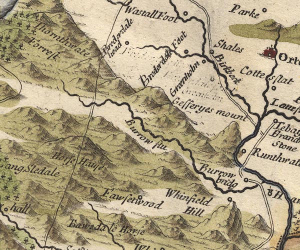
Kentmere -- valley -- NY457040 (etc)
-- 'Kentmere' -- Circle, building and tower.
Kentmere Tarn -- lake -- NY455028 (approx) -- Outline with shore shading, tinted blue. Longsleddale -- valley -- NY4904 (etc) -- 'Lang Sledale' -- Circle, marked high up the valley. Naddle Forest -- forest -- NY495145 (etc) ? -- 'Thornthwate Forrest' -- Trees. Ambleside to Kirkstone Pass -- road -- route -- NY3906 (etc) -- Double line. Rydal Beck -- river -- NY3608 -- 'Rathey' -- Labelling the wrong river. Sleddale Forest -- forest -- NY4802 & NY4801 -- Trees in Longsleddale and Kentmere. Troutbeck -- building/s -- NY4103 -- 'Troutbeck' -- Circle, building and tower. Ubarrow Hall -- building/s -- NY50390261 -- 'Ewbarrow hall' -- Circle. | |
 MD10NY50.jpg
 |
Birk Beck -- river -- NY5808
-- 'Birkbeck'
Borrow Beck -- river -- NY5503 -- 'Burrow flu' Bretherdale Beck -- river -- NY5804 (etc) -- Running into Birkbeck. Bretherdale Foot -- building/s -- NY596043 -- 'Brederdale Foot' -- Circle, the label re-engraved and re-positioned, and in the wrong position wrt Greenholme ... Bretherdale Head -- building/s -- NY5705 -- 'Brederdale head' -- Circle, the label re-engraved and re-positioned. Fawcett Forest -- locality -- NY5303 (etc) -- 'Fawsetwood' -- Circle. Greenholme -- building/s -- NY597057 -- 'Groenholm' -- Circle, the label re-engraved and re-positioned, the earlier spelling might be Greenholm. Horse House (?) -- building/s -- NY541041 (?) -- 'Horse Hause' -- Perhaps a pass, no symbol. Jeffrey's Mount -- hill -- NY603024 -- 'Gefferyes mount' -- Hillock. Low Borrowbridge -- building/s -- NY609014 -- 'Burrow bridg' -- Circle. Lune's Bridge -- bridge -- NY61300286 ? -- Road river crossing ???. Kendal to Shap -- route -- road -- SD59 -- Double line. Shap to Tebay -- route -- road -- NY51 -- Double line. Roundthwaite -- building/s -- NY608023 -- 'Runthwate' -- Circle. Whinfell Beacon -- hill -- beacon -- NY57350029 -- 'Whinfield Hill' -- Circle, on a hillock. | |
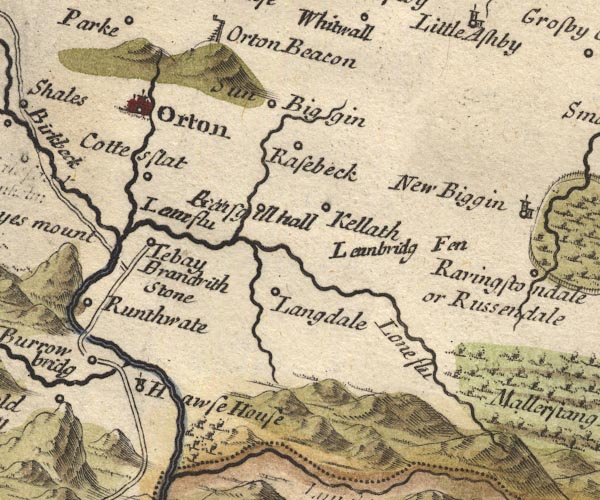 MD10NY60.jpg
 |
Brandrith Stone -- stone -- NY6104 (?)
-- 'Brandrith Stone' -- No symbol.
Chapel Beck -- river -- NY6206 (etc) -- Running into the Lune. Coatflatt Hall -- building/s -- NY621059 ? -- 'Cottesflat' -- Circle. Hawse House (?) -- building/s -- house -- NY608006 -- 'Hawse House' -- Circle, tower. Kelleth -- building/s -- NY661052 -- 'Kellath' -- Circle. Langdale Beck -- river -- NY6402 (etc) -- Running into the Lune. Langdale -- valley -- NY6502 (etc) -- 'Langdale' -- Circle. Low Borrow Bridge -- bridge -- NY60930143 -- Road crossing and interrupting the Borrow Beck. Lune, River -- river etc -- NY6205 (etc) -- Lune Flu -- With the county boundary drawn alongside. Lunebridge Fen (?) -- fen -- moor -- NY6605 -- 'L[ea]nbridg Fen' -- No symbol. Orton -- building/s -- NY621083 -- 'Orton' -- Circle, buildings, towers. Rais Beck -- river -- NY6407 (etc) -- Running into the Lune. Raisbeck -- building/s -- NY645075 -- 'Rasebeck' -- Circle. Raisgill Hall -- building/s -- NY635058 -- 'Raisgill hall' -- Circle; the engraving botched. Kendal to Appleby -- route -- SD59 -- Double line. Sunbiggin -- building/s -- NY658086 -- 'Sun Biggin' -- Circle. Tebay -- building/s -- NY616045 -- 'Tebay' -- Circle. Tebay Bridge, Tebay ? -- Road crossing and interrupting the Lune; some much here is confused by motorway and railway that identification is uncertain. | |
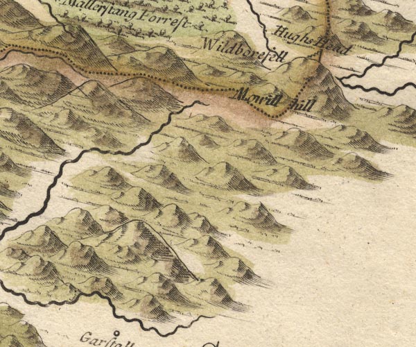
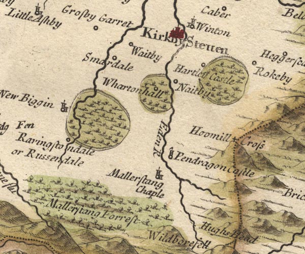 MD10NY70.jpg
 |
Eden, River -- river etc -- NY3658 (etc)
-- 'Eden R' -- With the county boundary drawn alongside.
Hartley Castle -- castle -- NY782082 -- 'Hartley Castle' -- park -- Circle, outside a park - ring of fence palings, trees. Hollow Mill Cross -- boundary stone -- NY81180405 -- 'Hoomill Cross' -- Marked by cross on a hillock. Kirkby Stephen -- building/s -- NY775086 -- 'Kirkby Steven' -- Circle, buildings, towers. Mallerstang Forest -- forest -- NY70 (?) & SD79 (?) -- 'Mallerstang Forrest' -- Trees. Nateby -- building/s -- NY7706 -- 'Naitby' -- Circle. Newbiggin-on-Lune -- building/s -- NY705051 -- 'New Biggin' -- Circle, building and tower. Pendragon Castle -- castle -- NY78180263 -- 'Pendragon Castle' -- Circle, tower with a flag. Ravenstonedale -- building/s -- NY7204 -- 'Ravingstondale or Russendale' -- Circle. Ravenstonedale Park -- park (ex) -- NY7205 ? -- Ring of fence palings, trees. Smardale -- building/s -- NY739080 (etc) -- 'Smardale' -- Circle. St Mary's Chapel -- church -- chapel -- NY78190142 -- 'Mallerstang Chaple' -- Circle, building and tower. Waitby -- building/s -- NY7508 -- 'Waitby' -- Circle. Wharton Hall -- building/s -- NY770062 -- 'Whartonhall' -- park -- Circle, in its park - ring of fence palings, trees. Winton -- building/s -- NY784105 -- 'Winton' -- Circle, building and tower. | |
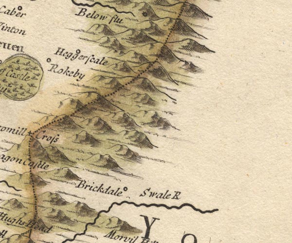 MD10NY80.jpg
 |
Birkdale -- building/s -- NY8501
-- 'Brickdale' -- Circle.
Heggerscales -- building/s -- NY811104 -- 'Heggerscale' -- Circle. Rookby -- building/s -- NY803109 -- 'Rokeby' -- Circle. Swale, River -- river -- NY80 (etc) -- 'Swale R' | |
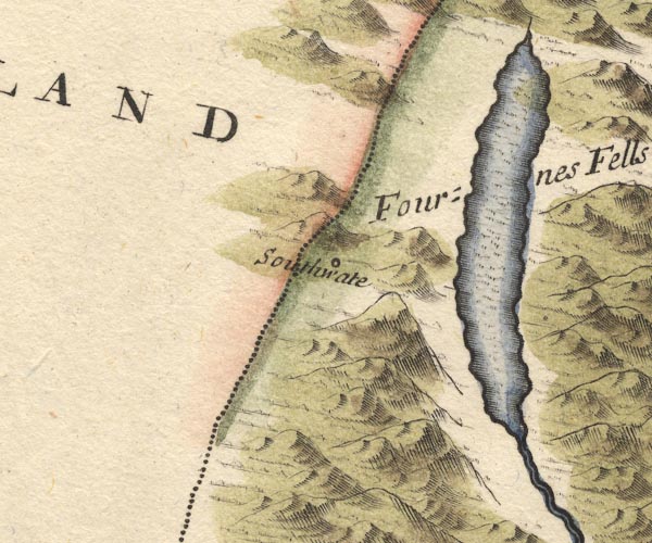 MD10SD29.jpg
 |
Coniston Water -- lake -- SD302943
-- Outline with shore shading, tinted blue.
Furness Fells -- hill -- fell -- SD3389 (etc) -- 'Fournes Fells' -- Hillocks. Seathwaite -- building/s -- SD227960 ? -- 'Southwate' -- Circle. | |
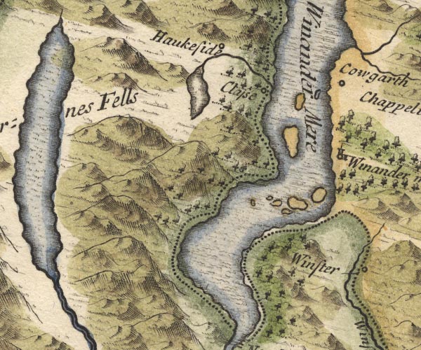 MD10SD39.jpg
 |
Winander Mere
-- 'Winander mere' -- Circle, building and tower.
Calgarth Hall -- building/s -- SD398996 ? -- 'Cowgarth' -- Circle. Claife -- area -- SD3798 (etc) -- 'Classe' -- Circle. Esthwaite Water -- lake -- SD3696 (etc) -- Outline with shore shading, tinted blue; the stream shown from the north end running to Windermere lake is completely wrong, the Cunsey Beck runs from the south end to the lake. Hawkshead -- building/s etc -- SD351980 -- 'Haukeside' -- Circle. Windermere -- lake -- SD392950 ? -- 'Winander Mere' -- Outline with shore shading, tinted blue; nine unlabelled islands; the county boundary drawn along the east shore. | |
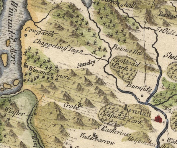 MD10SD49.jpg
 |
bridge, Bowston -- bridge -- SD49869660 ?
-- Double line over the Kent NW of Burneside.
bridge, Burneside -- bridge -- SD50529580 ? -- Double line over the Kent, at Burneside. Burneside -- building/s -- SD5095 -- 'Burnside' -- Circle. Crook -- building/s -- SD464951 -- 'Croke' -- Circle, building and tower. Cunswick Hall -- building/s -- park -- SD486934 -- 'Cunswick Park' -- Ring of fence palings, trees, with a circle. Gowan, River -- river -- SD4598 -- Running into the Kent. Height of Patton -- hill -- SD550967 ? ? -- 'Betone Hill' -- Hillock(s). Ings -- building/s -- SD445986 -- 'Chappel in ye Ing' -- Circle. Clonhead Park -- park -- SD4997 -- 'Clonhead Park' -- Ring of fence palings, trees. Kendal to Shap -- route -- road -- SD59 -- Double line. St Catherine's Church -- church (remains) -- tower -- SD45009467 ? -- 'S Katherines' -- Circle. Staveley -- building/s etc -- SD470984 -- 'Staveley' -- Circle. Trout Beck -- river -- NY4104 (etc) ? -- Running into Windermere, shown the wrong side of Calgarth. Winster -- building/s -- SD418935 -- 'Winster' -- Circle. | |
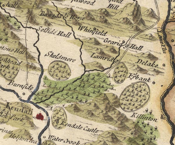 MD10SD59.jpg
 |
Bannisdale -- valley -- NY5103 (etc)
-- 'Ba[w]sdale Horse' -- No symbol, perhaps a valley or
pass.
Grayrigg Hall Beck -- river -- SD5797 (etc) -- Tributary to the Mint. Grayrigg Hall -- building/s -- SD57949750 -- 'Graridg Hall' -- Circle. Kendal -- building/s etc -- SD514926 -- 'Kendall' -- Circle, buildings, towers. Kendal Castle -- castle -- SD521924 -- 'Kendale Castle' -- park -- Circle, tower, in a park - ring of fence palings, trees. Lambrigg Park -- park -- SD595942 (etc) ? ? -- 'Lamridg' -- Ring of fence palings, trees?. Laverock Bridge -- packhorse bridge -- bridge (ex) -- SD53569517 ? -- Double line over a stream, over the Mint. Mint Bridge -- bridge -- SD52209426 ? -- Double line over the Mint N of Kendal. Mint, River -- river -- SD5596 Nether Bridge -- bridge -- SD516919 -- Road and river intersect. Old Park -- park -- SD6089 ? ? -- Ring of fence palings, trees, S of Firbank. Kendal to Appleby -- route -- SD59 -- Double line. Kendal to Shap -- route -- road -- SD59 -- Double line. Selside Hall -- building/s -- SD5399 ? -- 'Selside Hall' -- Circle. Skelsmergh Hall Farm -- building/s -- SD531959 -- 'Skelsmere' -- park -- Ring of fence palings, trees?. Sprint Bridge -- bridge -- SD51329602 -- Double line over a stream crossing the Sprint. Sprint, River -- river etc -- NY4806 (etc) Stramongate Bridge -- bridge -- SD51859297 -- Double line over a stream, over the Kent. Whinfell -- locality -- NY5700 -- 'Whinfield' -- Circle. | |
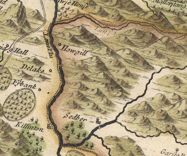 MD10SD69.jpg
 |
Carlingill Beck -- river -- boundary -- county boundary
(once) -- parish boundary -- SD6399 (etc)
-- With the county boundary drawn alongside; a label 'Lun
flu' is erased.
Clough River -- river -- SD7389 (etc etc) Crook of Lune Bridge -- bridge -- SD62029631 -- Double line over the Lune south of Howgill. Dee, River -- river -- SD7186 (etc etc) ? Delaken (??) -- building/s -- SD6295 -- 'Delake' -- Circle. Firbank -- building/s -- SD626940 (etc) -- 'Firbank' -- Circle. Howgill -- SD6396 (etc) -- 'Howgill' -- Circle. Killington -- building/s -- SD6188 ? -- 'Killinton' -- Circle, building and tower. Lune, River -- river etc -- NY6205 (etc) -- 'Lone Flu' -- With the county boundary drawn alongside. Sedbergh -- building/s -- SD662921 -- 'Sedber' -- Circle, building and tower. Sedbergh New Bridge (?) -- bridge -- SD66519194 ? -- Double line over a stream over the Rawthey. | |
 MD10SD79.jpg
 |
beacon, Hugh Seat -- beacon -- SD808991 (?)
-- Beacon, post and ladder, on Hughs Seat.
Hugh Seat -- hill -- SD80919910 -- 'Hughs Head' -- 'Mowill hill' -- Hillock; the two labels copied from earlier maps have become separated. Wild Boar Fell -- hill -- fell -- SD7598 -- 'Wildborefell' -- Hillock. | |
 MD10SD28.jpg
 | ||
 MD10SD38.jpg
 |
Crake, River -- river etc -- SD2987 (etc)
Leven, River -- river etc -- SD3483 (etc) ? Newby Bridge -- bridge -- SD36918636 ? -- 'New Bidge' -- Double line over a stream. | |
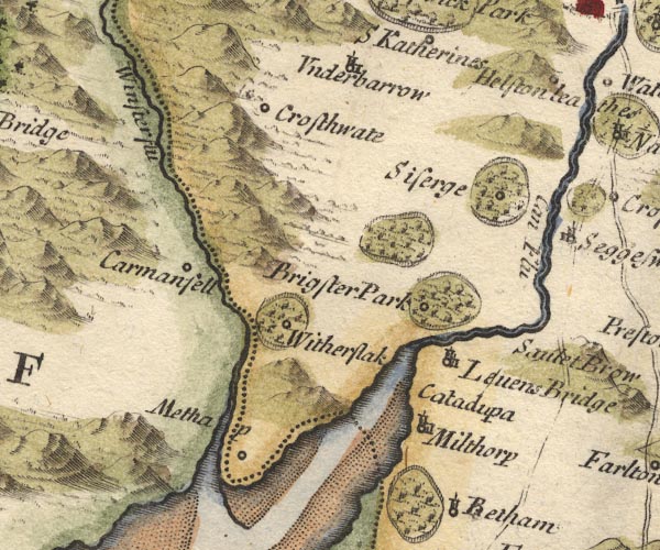 MD10SD48.jpg
 |
Brigsteer Park -- park -- SD4888
-- 'Brigster Park' -- Ring of fence palings, trees, with
circle.
Cartmel Fell -- building/s -- SD415880 (etc) ? -- 'Carmanfell' -- Circle. Catadupara -- (?) -- SD4682 (guess) -- 'Catadup~a' -- No symbol (or is this Milnthorpe or Levens???). Crosthwaite -- building/s -- SD437915 -- 'Crosthwate' -- Circle. Helsington Laithes -- building/s -- SD506907 ? -- 'Helston lea' -- Circle. Kent, River -- river etc -- NY4506 (etc) -- 'Can Flu' Levens Bridge -- bridge -- SD49618522 -- 'Levens Bridge' -- Circle, building and tower. Levens Park -- park -- SD5085 -- 'Brigsteer Park' -- Ring of fence palings, trees, and a circle for the house. Meathop -- building/s -- SD4380 -- 'Methap' -- Circle. Milnthorpe -- building/s -- SD496815 -- 'Milthorp' -- Circle, building and tower. Sizergh Castle -- building/s -- house -- park -- SD4987 -- 'Siserge' -- park -- Circle, in its park - ring of fence palings, trees. Underbarrow -- building/s -- SD465922 -- 'Underbarrow' -- Circle, building and tower. Winster, River -- river -- SD4285 (etc) -- 'Winster flu' -- With the county boundary drawn alongside. Witherslack -- building/s -- SD4383 -- 'Witherslack' -- Circle, in a park. Witherslack Hall -- building/s -- park -- SD436861 -- park -- Ring of fence palings, trees, around Witherslack. | |
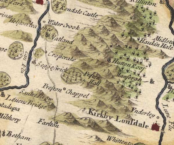 MD10SD58.jpg
 |
Crosscrake -- building/s -- SD524870
-- 'Crosscrake' -- Circle.
Farleton -- building/s -- SD535810 -- 'Farlton' -- Circle. Hutton Roof -- building/s -- SD5778 -- 'Hutton Roof' -- Circle, building and tower. Natland -- building/s -- SD5289 -- 'Natland' -- Circle, building and tower, in a park. Natland Park -- building/s -- SD521897 -- Ring of fence palings, trees, around Natland. park, Sedgwick -- park -- SD5187 -- Ring of fence palings, trees, N of Sedgwick. Preston Patrick Hall -- building/s -- SD544837 ? -- 'Preston Hall' -- park -- Circle, by a park - ring of fence palings, trees. Lancaster to Kendal -- route -- road etc -- SD46 -- Double line, through Farleton. -- Double line, through Sedgwick. Sedgwick -- building/s -- SD5187 -- 'Seggeswick' -- Circle, building and tower. Sellet Brow (?) -- hill -- SD520856 -- 'Saulet Brow' -- Hillock. St Patrick's Church -- church -- SD53698351 -- 'Preston Chappel' -- Circle. Watercrook -- locality -- SD514906 (etc) -- 'Water Crook' -- Circle. | |
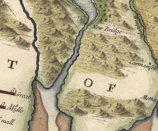
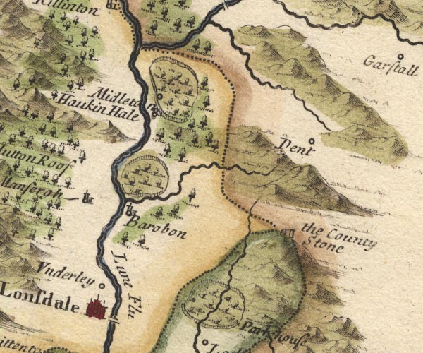 MD10SD68.jpg
 |
Barbon -- building/s -- SD6282
-- 'Barobon' -- Circle, building and tower.
Barbon Beck -- river -- SD6482 -- Running into the Lune at Barbon. Barbon Park -- park -- SD6483 -- Ring of fence palings, trees, by Barbon. County Stone -- boundary stone -- stone -- SD70148274 -- 'the County Stone' -- A pair of stones on a hillock, at the meet of three counties. Dent -- building/s -- SD705871 -- 'Dent' -- Circle. Devil's Bridge -- bridge -- SD61557823 -- Double line over a stream, over the Lune. Fairthwaite Park -- park -- SD6377 -- 'Park house' -- Ring of fence palings, trees, and Park House. Hawking Hall -- building/s -- SD619857 -- 'Haukin Hale' -- Circle, tower. Kirkby Lonsdale -- building/s -- SD6178 -- 'Kirkby Lonsdale' -- Circle, buildings, towers. Lune, River -- river etc -- NY6205 (etc) -- 'Lune Flu' -- With the county boundary drawn alongside. Mansergh -- building/s -- SD6082 -- 'Mansergh' -- Circle, building and tower. Middleton Hall -- building/s -- park -- SD626875 -- 'Midleton' -- park -- Circle, in ring of fence palings, trees. Rawthey, River -- river -- SD6894 (etc etc) ? -- Into the Lune. Underley Hall -- building/s -- school -- SD6180 -- 'Underley' -- Circle. | |
 MD10SD78.jpg
 |
Garsdale -- building/s -- SD7489
-- 'Garstall' -- Circle.
| |
 MD10SD27.jpg
 | ||
 MD10SD37.jpg
 |
Cartmel Sands -- sands -- SD3376 (etc)
Leven Estuary -- estuary -- river estuary -- sea area -- SD3375 (etc) Ulverston Sands -- sands -- SD3074 (etc) | |
 MD10SD47.jpg
 |
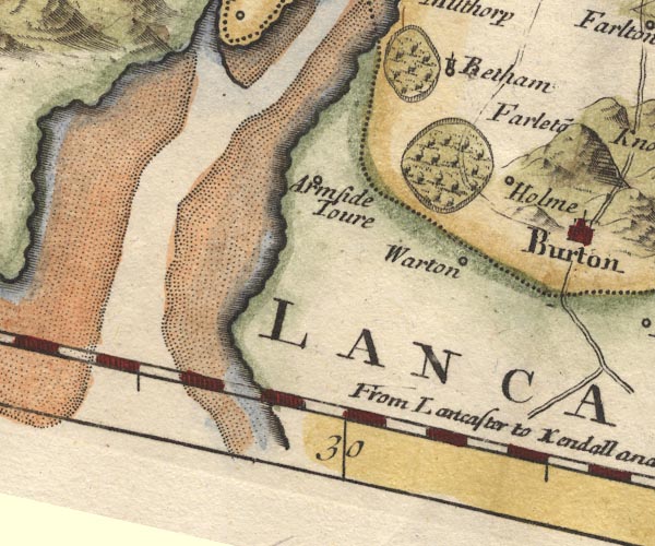
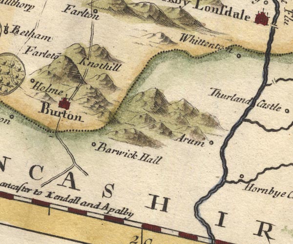
Arnside Tower -- tower -- SD458768
-- 'Armside Toure' -- Circle.
Beetham -- building/s -- SD4979 -- Circle, tower, by a park. Beetham Park -- park -- SD4978 -- Ring of fence palings, trees, by Betham. Holme -- building/s -- SD5279 -- 'Holme' -- Circle. Holme Park -- park (gone?) -- SD5379 -- Ring of fence palings, trees. Kent Estuary -- estuary -- river estuary -- sea area -- SD4377 (etc) Lancashire Sands Lancaster to Kendal -- route -- road etc -- SD46 -- Double line, through Farleton. -- Double line, through Sedgwick. Warton -- building/s -- SD5072 -- 'Warton' -- Circle. | |
 MD10SD57.jpg
 |
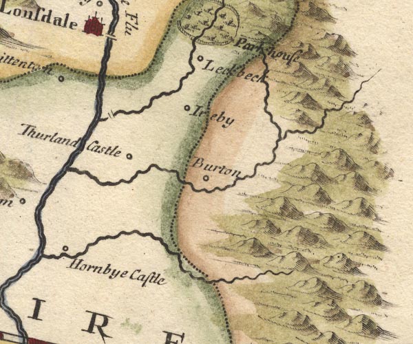
Arkholme -- building/s -- SD583722
-- 'Arum' -- Circle.
Borwick Hall -- building/s -- house -- SD527729 -- 'Barwick Hall' -- Circle. Burton-in-Kendal -- building/s -- SD531765 -- 'Burton' -- Circle, buildings, towers. Farleton Knott -- rocks -- SD5480 ? -- 'Farleto~ Knothill' -- Hillock. Hornby Castle -- castle -- SD587686 -- 'Hornbye Castle' -- Circle. Lancaster to Kendal -- route -- road etc -- SD46 -- 'From Lancaster to Kendall and Apalby' -- Double line, through Farleton. -- Double line, through Sedgwick. Wenning, River -- river -- SD571683 -- Into the Lune at Hornby. Whittington -- building/s -- SD600763 -- 'Whittenton' -- Circle. | |
 MD10SD67.jpg
 |
Burrow Bridge -- bridge -- SD614755
-- Double line over a stream.
Burton in Lonsdale -- building/s -- SD652722 -- 'Burton' -- Circle. Greta, River -- river -- SD599728 -- Running into the Lune. Ireby -- building/s -- SD654755 -- 'Ireby' -- Circle. Leck Beck -- river -- SD610754 Leck -- building/s -- SD643767 ? -- 'Leckbeck' -- Circle. Thurland Castle -- castle -- SD610730 -- 'Thurland Castle' -- Circle. Twiss, River -- river -- SD694732 | |
 MD10SD66.jpg
 | ||
 Lakes Guides menu.