 West 1784 map

|

|
|

|
back to object record | |
| MAP FEATURES | ||
|
A significant addition to the original map of 1784, is
relief shown by hill hachuring.
|
||
|
|
||
|
title
publisher |
Printed left middle:-
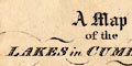
A Map of the LAKES in CUMBERLAND WESTMORELAND and LANCASHIRE Printed at bottom centre:- Published June 1, 1811, by Longman, Hurst, Rees, Orme and Brown, Paternosterrow, London. |
|
|
|
||
|
orientation
up is W |
The map has no indicator of orientation; it is printed
with West at the top of the sheet.
|
|
|
|
||
| scale |
The map has no indicator of scale. The map scale is
about:-
3.5 miles to 1 inch |
|
|
|
||
|
sea area
sea plain |
The sea area is plain, labelled:-
THE IRISH SEA |
|
|
|
||
|
coast line
coast form lines headlands foreshore |
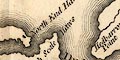
The coast line is emphasized by form lines. Some headlands are labelled, eg:- Humphry Point Hedbarrow Pt. Foreshore sands and shallows are labelled, not marked, eg:- Duddon Sands Lancaster Sands |
|
|
|
||
|
rivers
bridges ferries |
Rivers are drawn by wiggly line, tapering upstream. Some rivers are labelled, eg:- Kent River Greeta R. A waterfall might be noticed, for example:- Waterfall on the Kent above Levens Park, and another at Ambleside. Bridges are implied where a road crosses and interrupts a stream. A bridge might be labelled, eg:- 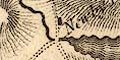
Newby Bridge Airey Bridge Although not marked or labelled, the layout of roads halfway down Windermere suggests the ferry there. |
|
|
|
||
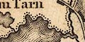
| lakes |
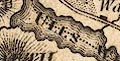
Lakes are drawn in outline, with form lines. Many are labelled:- Angle Tarn BASSENTHWAITE WATER Blea Tarn [above Watendlath] Blellum Tarn Broad Water [Brother Water] Burnmoor Tarn BUTTERMERE CROMMACK WATER DERWENT WATER DEVOCK WATER Elter Water ENNERDALE WATER ESTHWAITE WATER GRASMERE HAWES WATER Hayes Water LEATHES WATER Lever Water Loughrigg Tarn LOWES WATER Over Water Rydal Water Skeggles Water Sprinkling Tarn THURSTON or CONISTON WATER ULLS WATER WAS WATER Watendlath Tarn WINDERMERE [ ] Tarn [NW of Torver] Other lakes or tarns might be recognized, eg:- Bleaberry Tarn Easedale Tarn Kentmere Tarn [above Easedale] [decoy pond at Lowther] |
|
|
|
||
|
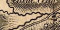
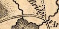
relief
hill hachuring |
Relief is indicated by hill hachuring. The engraving
shows a concentration of hills where it should, but also
obscures the engraving of placenames, especially hill names.
Some hills are labelled, eg:-
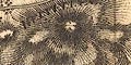
HELVELLYN SHAPFELLS Underbarrow Scar Grassmire Hill Kidsey Pike Some valleys are labelled, eg:- Eskdale St John's Vale |
|
|
|
||
| parks |
A few parks are drawn by a rounded outline with fence
palings, the interior pecked. The label might be just:-
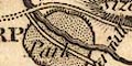
Park or a name as:- Gowbarrow Park Or a great house might identify the park:- Greystock Castle |
|
|
|
||
| county |
County boundaries are a fine dotted line, carried on alongside a feature which is the boundary. The county areas, remember this is not a county map, are labelled, eg:- PART OF WESTMORELAND And two regions in Lancashire are labelled,:- HIGH FURNESS LOW FURNESS |
|
|
|
||
|
settlements
street plan |
Settlements are marked by blocks or groups of blocks,
which might make a minimal street plan, differentiated by
style of labelling.
|
|
| towns |
group of blocks, perhaps on a street plan; labelled in
upright block caps, eg:-
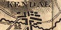
KENDAL COCKERMOUTH SHAP |
|
|
villages
hamlets houses |
block or blocks; labelled in italic lowercase text,
eg:-
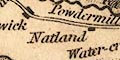
Natland Bootle Witherslack Dalmain Notice the:- 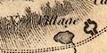
New Village marked by two semicircles of buildings at Lowther. Both upright and italic lowercase are used for other map features. |
|
|
|
||
|
roads
sands roads |
A network of roads is drawn by double line, solid or dotted possibly suggesting roads or tracks. 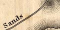
The routes across the sands at Lancaster sands and Leven and Ulverston Sands are shown as definite roads. The map originated in a guide book with planned itineraries, which might have influenced what roads were included. |
|
|
|
||
| miscellaneous | ||
|
|
||
| religious houses |
A religious house might be marked by a drawing of a
building with towers with crosses as at:-
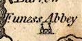
Funess Abbey or by a block as at:- Abbey [Shap] Conishead Priory |
|
|
|
||
| castles |
A castle might be marked by a drawing of a building with
two towers as at:-
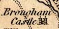
Brougham Castle Gleaston Castle |
|
|
|
||
|
antiquities
roman sites roman forts |
A roman site might be marked by a block as at:-
Roman Camp [Hutton Moor] Camp [Ambleside] |
|
|
|
||
|
antiquities
earthworks |
A circle marks:-
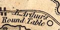
King Arthur's Round Table |
|
|
|
||
| pillars |
East of Penrith is labelled, but not marked:-
Ladys Pillar ie the Countess Pillar. |
|
Lakes Guides menu.