 West 1784 map

|

|
|

|
back to object record | |
| MAP FEATURES | ||
|
|
||
|
title
engraver |

There is no title cartouche; printed middle left is:- A MAP of the LAKES in Cumberland, Westmorland and Lancashire Printed bottom left and right, is:- Paas sculp. / No.53 Holborn The map includes only parts of each of the three counties; from 2 or 3 miles south of Lancashire to 3 or 4 miles north of Penrith, from Bootle and Ravenglass in the west to Shap in the east. The map sheet corners are, from bottom left clockwise, roughly:- SD064469 & NY089421 & NY631406 & SD606455 |
|
|
|
||
|
orientation
north point up is W |
Printed on the left is a north point; N-S line, North marked by a fleur de lys, E-S line, East marked by a simple cross. The map is printed with West at the top of the sheet; the sheet is in landscape orientation to fold longways into the guide book. |
|
|
|
||
|
scale line
scale |
Printed lower left is a:-
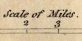
Scale of Miles marked and labelled at 1 miles. The 5 miles = 34.8 mm gives a scale 1 to 209550 unsafely assuming a statute mile. The map scale is about:- 1 to 210000 3 miles to 1 inch |
|
|
|
||
| table of symbols |
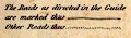
Printed below the title on the left is an explanation of the convention for roads, other symbols are taken for granted:- The Roads as directed in the Guide are marked thus [double line, solid] Other Roads thus [double line, dotted] On this copy of the map the described routes are also tinted brown. |
|
|
|
||
|
sea area
sea plain |
The sea is plain, with one sea area labelled:-
THE IRISH SEA |
|
|
|
||
|
coast line
coast form lines foreshore headlands |
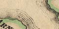
The coast is emphasised by form lines, engraved decoratively around islands and into river estuaries. Foreshore areas are not marked, but three are labelled:- Lancaster Sands Leven and Ulverston Sands Duddon Sands Roads, or rather routes, and shown across the first two: from Hest Bank across Lancashire Sands to Carter House near Cartmel; and two short routes across the Crake estuary near Ulverston. Some headlands are noticed, eg:- Humphry Point [S of Cartmel] |
|
|
|
||
|
rivers
bridges ferries lakes waterfalls |
Rivers are drawn by wiggly lines tapering upstream from
their estuaries which have form lines. Some are labelled,
eg:-
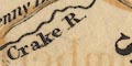
Crake R. Kent River Cockley Beck Many rivers are shown, but the countless small becks! Lakes are drawn in outline, with form lines, mostly tinted blue. Many are labelled, eg:- 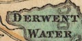
DERWENT WATER 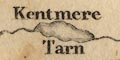
Kentmere Tarn WINDERMERE WATER THURSTON OR CONISTON WATER Islands are shown in the lakes. Bridges are not drawn, but are implied where a road crosses and interrupts a stream. A few are labelled, eg:- Duddon Bridge Ouse Bridge Pooley Bridge A couple of waterfalls are noticed:- 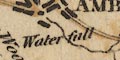
Waterfall [E side of Ambleside] Waterfall [on the Kent, E if Sizergh] The alignment of roads either side of Windermere water, south of Bowness, suggests a ferry. |
|
|
|
||
|
relief
hill hachuring |
Very little relief is shown on the map; and this is the
highest and most rugged part of England! There are slight
hachures for a few mountains and edges, labelled, eg:-
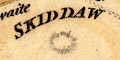
SKIDDAW FARLETON KNOT Underbarrow Scar HILL BELL Langdale Pikes Other relief features are labelled, without hachures, eg:- 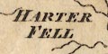
HARTER FELL COPELAND FOREST Holling Fell Honister Crag And at least one valley is labelled:- Eskdale separately from its river, Esk River, which is labelled lower down. |
|
|
|
||
| parks |
A few parks are shown, drawn in outline with fence
palings, perhaps labelled, eg:-
Park south of Sedgwick. Perhaps with a house inside, eg:- 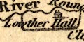
Lowther Hall |
|
|
|
||
| county |
County boundaries are a fine dotted line, often alongside a river line. The county areas are labelled, e:- PART OF WESTMORLAND Each county has a tint along the inside of its border: Cumberland yellow, Westmorland, green, Lancashire red. Lancashire North of the Sands, not labelled separately, is a detached part of the county. |
|
|
|
||
| settlements |
Settlements are indicated by blocks or groups of blocks,
and differentiated by style of labelling.
|
|
|
towns
villages |
group of blocks by the roads; labelled in upright block
caps, eg:-
KENDAL LANCASTER SHAP AMBLESIDE |
|
|
villages
hamlets |
block or blocks; labelled in italic lowercase text,
eg:-

Staveley Patterdale Long Sleddale Barrow Notice the New Village drawn by opposing semicircles of building blocks to the east of Lowther Hall. |
|
|
Lowercase italic lettering is used for various other
features on the map.
|
||
|
|
||
| roads |
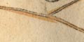
Roads are drawn by double lines; solid lines for the routes described in the guide book, tinted brown, 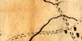
dotted for other roads. The destination of some roads going off the map are labelled, eg:- To Carlisle To Sedbergh 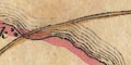
Notice the roads, or rather routes, across the Lancaster Sands and the sands near Ulverston. |
|
|
|
||
| canals |
The canal through Lancaster to Kendal is shown by a
triple line, light bold light, labelled:-

Lancaster Canal The canal opened through to Kendal on 1819. It had been proposed about 1792, and was open in southerly stretches in the 1800s. The canal is an addition to the map. It does not appear on the copy of this map tipped into the 1793 edition of the Guide to the Lakes in the Armitt collection. Near Lancaster the canal is shown going under the River Lune. The canal goes OVER the river here on an stone aqueduct built by John Rennie, 1798. Near Tewitfield are:- Locks shown by arrows on the line of the canal. And near Sedgwick is a:- Tunnel |
|
|
|
||
| miscellaneous | ||
|
|
||
| stones |
The:-
Bowther Stone [by Grange] is noticed. |
|
|
|
||
|
antiquities
henges |
A circle of dots above Keswick is labelled:-
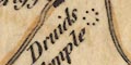
Druids Temple just by the village of Castlerigg. Near the road crossing of the Emmont River is:- K. Arthurs Round Table |
|
|
|
||
|
antiquities
roman sites roman forts |
At the south of Ambleside is a small rectangle
labelled:-
Camp and on Mell Fell, half way between Penrith and Threlkeld is:- 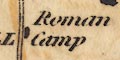
Roman Camp |
|
|
|
||
|
antiquities
castles |
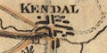
At Kendal, for example, there is a picture of a building
labelled:-
Castle |
|
|
|
||
| boundary marks |
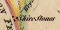
Near the Wrynose Pass, where three counties meet,
is:-
Shire Stones |
|
|
|
||
| monuments |
South of Wythburn is a group of small circles
labelled:-
Dunmail Raise Stones This cairn is thought to be a monument to Dunmail, last king of Cumberland, died 945. A dot in the road to Appleby from Eamont Bridge is labelled:- Ladys Pillar |
|
|
|
||
| towers |
A drawing of several layers of building, rather like some
period drawings of the Tower of Babel, in the south, is
labelled:-
Arnside Tower |
|
|
|
||
| beacons |
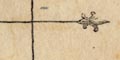
On the Lancashire coast near Warton is a drawing of a
tower labelled:-
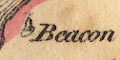
Beacon |
|
|
|
||
|
mills
gunpowder mills |
On the Leven River, a couple of miles north of the
estuary, are:-
Gunpowder Mills and at Natland south of Kendal:- Powdermills |
|
|
|
||
| furnaces |
A few works are labelled as:-

Newland Furnace [by Ulverston] Backbarrow Furnace [S of Newby Bridge] |
|
|
Notes about the guide book from which this map comes:-
|
||
Lakes Guides menu.