 Wallis 1810

|

|
|

|
back to object record | |
| MAP FEATURES | ||
|
|
||
|
title cartouche
plain cartouche map maker publisher |
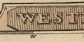
Printed in a shaded title cartouche in the upper border:- WESTMORELAND Printed at the bottom:- London Publish'd by W. Lewis, 21, Finch Lane. There is a page number, 36, top right. |
|
|
|
||
| table of symbols |
Printed at the bottom is an:-

Explanation _ County Town thus KENDALL [block caps] Market Towns Orton [upright lowercase] Villages Brains [italic lowercase, placename] Seats and Parks [outline with fence palings] Canals [triple line, light bold light] Rivers [wiggly line] Mail Coach Roads [double line with cross lines] Turnpike Roads [double line, light bold] The Small figures denote the distance of each place from London 257 The stars the number of members each place sends to Parliament [asterisk] --- |
|
|
|
||
|
orientation
compass rose up is E |
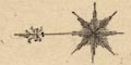
Printed upper right is a compass rose; no circle, star points for cardinal and half cardinal directions, North marked by a fleur de lys. The map is printed with East at the top of the sheet, not that much id gained as the county is nearly 'square'. |
|
|
|
||
|
scale line
scale |
Printed lower right is a:-
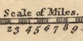
Scale of Miles. chequered and labelled in miles. The 10 miles = 13.2 mm gives a scale 1 to 1219200 assuming a statute mile. The map scale is about:- 1 to 1200000 19 miles to 1 inch |
|
|
|
||
|
lat and long
lat and long scales |
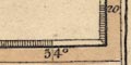
Printed in the map borders are scales of latitude and longitude for a rectangular projection; chequered and labelled at 5 minute intervals of latitude, 10 minutes of longitude. The right scale, South, longitude, is labelled:- Long. W fr. Lond. The bottom scale, West, latitude is labelled:- Long. W from London Whoops. From the longitude scale the longitude, Kendal = 2d 47m W suggesting a prime meridian 2d West of Greenwich, perhaps St Paul's Cathedral, BUT the size and accuracy of the map does not encourage faith in this deduction. The map includes from 2d 0m to 3d 20m W, from 53d 58m to 54d 27m N; all of Westmorland. |
|
|
|
||
|
coast line
coast shaded |
The tiny bit of coast line shown in the Kent Estuary is shaded to the right, ie south. |
|
|
|
||
|
rivers
bridges |
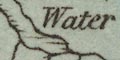
Rivers are drawn by wiggly line tapering upstream. Main rivers are shown with impressive arrays of tributaries, a little too regular for truth. Some rivers are labelled, eg:- Kent River Eden R. Bridges are implied where a road crosses and interrupts a stream. A few bridges are labelled, eg:- Lincolns Inn Br. Trout Beck Br. |
|
|
|
||
| lakes |
Lakes are drawn in outline with shading mostly to the right, ie on the north bank, to the south. Some lakes are labelled:- Ulles Water Winander Mere Horns Water [Hawes Water] Others might be recognised, eg:- Brothers Water decoy pond, Lowther Rydal Water Grasmere Kentmere Tarn Skeggles Water Elter Water (?) |
|
|
|
||
| parks |
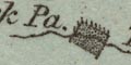
Parks are drawn in outline with fence palings, the interior pecked. Some are labelled, eg:- Trogtbeck Pa. Wharton Park |
|
|
|
||
|
county
distances from London electoral data |
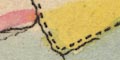
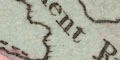
The county boundary is a dashed line. The line might not be continued along another feature which makes the boundary. The whole county is tinted blue. Adjacent counties are labelled, eg:- CUMBERLAND and each has a tint along its border; Cumberland yellow, Lancashire red, Yorkshire yellow, Durham red. A very little is shown outwith the county for the continuity of roads. |
|
|
|
||
| settlements |
Settlements are marked by blocks, differentiated by style
of labelling.
|
|
| towns |
blocks; labelled in upright lowercase text, eg:-
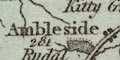
Ambleside / 281 Kirkby Stephen / 287 Appleby / 267 [2 stars] except:-Settlements are marked by blocks, differentiated by style of labelling. 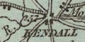
KENDALL in italic block caps as the de facto county town. The figures are the distances from London; the stars show how many members are returned to Parliament by a borough. |
|
|
villages
hamlets |
block or blocks; labelled in italic lowercase text,
eg:-
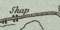
Shap Killah [Kellet] Thrimby |
|
|
This lettering is used generally for map features.
|
||
|
|
||
|
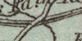
roads
post roads turnpike roads |
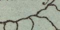
A network of roads is drawn by double line, differentiated as post roads or turnpike roads, explained in the table of symbols. Turnpike roads have bold light lines; post roads, mail coach roads, have cross hatching. Lines might be solid or dotted for fenced or unfenced, which produces a nice effect on the post roads - a row of little boxes. The post roads are:- from the south, Lancashire; through Burton, Kendal, Shap, Westmorland; then Penrith and north, Cumberland. from the east, Yorkshire; through Brough, Appleby, to join the N-S route just south of Penrith. Road destinations might be labelled at the county boundary, eg:- from Keswick to Settle and on the raod south from Kendal:- to |
|
|
|
||
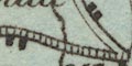
| canals |
Canals are drawn by a triple line, light bold light. |
|
| Lancaster Canal |
from the south, Lancashire; to Kendal, Westmorland. None
of the wiggles of the route are shown, and the canal stops
short of the town.
|
|
Lakes Guides menu.