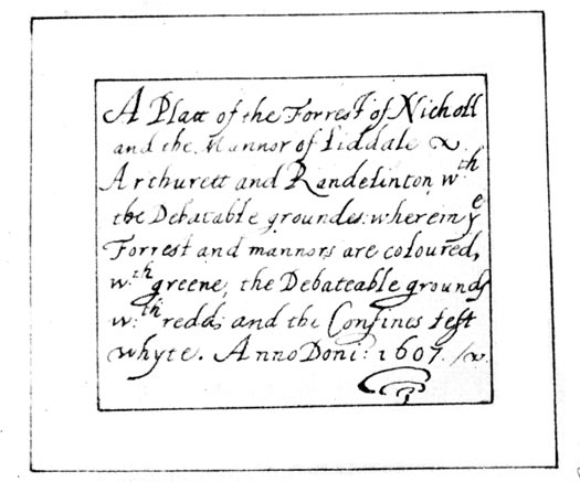
 Platt of the Forrest of Nicholl and the Mannor of
Liddale
Platt of the Forrest of Nicholl and the Mannor of
Liddale

|

|
|
|
map type:- Unknown 1607 |
|
|
|
Map, Platt of the Forrest of Nicholl and the Mannor of
Liddale, including the Debatable Land, Cumberland and
Scotland, 1607; published by Cumberland and Westmorland
Antiquarian and Archaeological Society, Kendal, Westmorland,
1914.
Reproduced with an article about the Debatable Land by T H B Graham. |
||
| inscription:- |
printed plain cartouche, upper left
A Platt of the Forrest of Nicholl / and the Manor of Liddale / Arthurett and Randelinton wth. / the Debatable grounds : wherein ye / Forrest and mannors are coloured / wth. greene.the Debateable grounds / wth. redd, and the Confines left / whyte. Anno Doni : 1607 |
|
| wxh, map (reproduction):- | 204x242mm | |
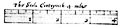
| inscription:- |
printed with the scale line
This Scale Conteyneth 4 miles |
|
| scale line (reproduction):- | 4 miles = 63.0 mm | |
| scale (reproduction):- | 1 to 100000 ? (1 to 102181 from scale line) | |
|
||
| references:- |
Graham, T H B: 1914: Debatable Land, The; part 2: Trans
CWAAS: 2nd series vol.14: pp.132-157; opp p.148 |
|
| sources:- |
National Archives (Maps and plans, Duchy of Lancaster
no.91) private collection |
|
| items seen (illustrated items in bold):- | ||

|
private collection (229) -- map -- Platt of the Forrest of Nicholl and the Mannor of Liddale | |