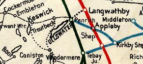
 Ullswater Steamers 1900s map

|

|
|
|
map type:- Ullswater Steamers 1900s map |
|
|
|
Railway map, London North Western, Midland, and North
Eastern Railways and their connections, published by the
Ullswater Steam Navigation Co, 2nd edn 1900s?
Included in the Souvenir and Guide to Ullswater together with railway fare tables for visiting The Lakes. |
||
|
(example JandMN (383_3)
|
||
| wxh, sheet:- | 21x28cm | |
| wxh, map:- | 199x262mm | |

|
||
| sources:- |
JandMN Collection |
|