 British High Roads, North and North Eastern
Routes
British High Roads, North and North Eastern
Routes

|

|
|
|
map type:- Tinsley 1877 |
|
|
|
Road book, itineraries and strip maps, British High
Roads, North and North Eastern Routes, published by Tinsley
Bros, 8 Catherine Street, Strand, London, 1877.
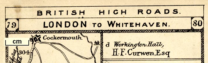
Advertised as part 1 of a series of 4. There is a contents list, index of places, index of residents of great houses and an index to these residences, a list of hotels with tariffs, and an index to advertisements which are missing from this volume. The strip maps are derived from Paterson's roads, qv. Published, part 1, as 'PART I. NORTH AND NORTH-EASTERN ROUTES. BRITISH HIGH ROADS. ARRANGED FOR THE USE OF TOURISTS. Illustrated by Forty-one Maps, On a Scale of 3/8 of an inch to the mile. IN FOUR PARTS. EACH PART COMPLETE IN ITSELF. PUBLISHED BY TINSLEY BROTHERS, 8, CATHERINE STREET, STRAND, LONDON, W.C. 1877. ALL RIGHTS RESERVED.] The itineraries and strip maps that concern Cumbria are:- Itinerary, route 3, London to Edinburgh and Glasgow via Boroughbridge and Carlisle, including from Bowes, Durham; through Brough, Appleby, Westmorland; then Penrith, Carlisle, Longtown, Cumberland; and into Scotland, published by Tinsley Bros, 8 Catherine Street, Strand, London, 1877. Itinerary, route 7, London to Whitehaven via the Lake Districts, including from Settle, Lancashire; through Kirkby Lonsdale, Kendal, Ambleside, Westmorland; then Keswick, Cockermouth to Whitehaven, Cumberland, published by Tinsley Bros, 8 Catherine Street, Strand, London, 1877. Strip maps 33-38, part of London to Edinburgh via Boroughbridge and Carlisle, including from Rey Cross; through Brough, Appleby, Westmorland; then Penrith, Carlisle, Longtown, Cumberland; and into Scotland published by Tinsley Bros, 8 Catherine Street, Strand, London, 1877. Strip maps 77-80, part of London to Whitehaven, including from before Kirkby Lonsdale through Kendal, Windermere, Ambleside, Westmorland; then Keswick, Cockermouth to Whitehaven, Cumberland, published by Tinsley Bros, 8 Catherine Street, Strand, London, 1877. |
||

|
Paterson 1785 | |
|
(private collecion (270))
|
||
| inscription:- |
printed title page
PART I. / NORTH AND NORTH-EASTERN ROUTES. / BRITISH HIGH ROADS. / ARRANGED FOR THE USE OF / TOURISTS. / Illustrated by Forty-one Maps, / On a Scale of 3/8 of an inch to the mile. / IN FOUR PARTS. / EACH PART COMPLETE IN ITSELF. // PUBLISHED BY / TINSLEY BROTHERS, 8, CATHERINE ST., STRAND, / LONDON, W.C. / 1877 / ALL RIGHTS RESERVED.) |
|
| inscription:- |
embossed cover
gold on red |
|
| inscription:- |
colophon: printed reverse of title page
ALABASTER & PASSMORE / PRINTERS LONDON |
|
| sources:- |
David Webb Collection |
|
| items seen (illustrated items in bold):- | ||
|
|
private collection (270) -- road book -- British High Roads, North and North Eastern Routes | |
|
|
private collection (270_3) -- strip map (pp.33-34) -- London to Edinburgh via Boroughbridge and Carlisle | |
|
|
private collection (270_4) -- strip map (pp.35-36) -- London to Edinburgh via Boroughbridge and Carlisle | |
|
|
private collection (270_5) -- strip map (pp.37-38) -- London to Edinburgh via Boroughbridge and Carlisle | |
|
|
private collection (270_6) -- strip map (pp.77-78) -- London to Whitehaven | |
|
|
private collection (270_7) -- strip map (pp.79-80) -- London to Whitehaven | |