 Cumberland, Physical Features

|

|
|
|
map type:- Thurnam 1910s-20s map 1 |
|
|
|
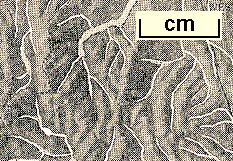
Relief map, halftone photographic image, physical
features of Cumberland, scale roughly 18 miles to 1 inch, by
E J Arnold and Son, Leeds, Yorkshire, published by Charles
Thurnam and Sons, Carlisle, Cumberland 1910s-20s.
Included on page 3 of Cumberland its Geography and History for Use in Schools. The image is much reduced from the original, it could possibly be a photograph of a framed relief model map. |
||
|
(example JandMN (270-1))
|
||
| map feature:- | up is N & sea plain & coast line & rivers & relief & hill shading & settlements (few) & roads (some) | |
| inscription:- |
printed bottom
Reproduced by permission of Messrs. E. J. Arnold & Sons, Leeds. |
|
| wxh, map:- | 107x127mm | |
| sources:- |
JandMN Collection |
|
| items seen (illustrated items in bold):- | ||

|
JandMN (270_1) -- relief map -- Cumberland, Physical Features | |