 Lake District, The

|

|
|
|
map type:- Stanford 1864 |
|
|
|
Geological maps, The Lake District, and North Cumberland,
each scale about 7 miles to 1 inch, by Edward Stanford, Long
Acre, probably published by James Reynolds, 174 Strand,
London, 1864.
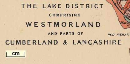
The Lake District has Westmorland with parts of Cumberland and Lancashire; the north sheet is North Cumberland and has the Isle of Man as an inset on the sheet. Published, probably, as plates 7 and 8 in a Portable Atlas of England and Wales ... by James Reynolds, 174 Strand, London, 1864. |
||
|
(map example JandMN (94))
|
||
| map feature:- | north point & up is N & scale line & sea plain & coast line & rivers & lakes & relief (very little) & hill hachuring & county & settlements & roads & railways & geology | |
| inscription:- |
printed plate 7 lower left
THE LAKE DISTRICT / COMPRISING / WESTMORLAND / AND PARTS OF / CUMBERLAND & LANCASHIRE |
|
| inscription:- |
printed plate 8 upper right
NORTH CUMBERLAND |
|
| inscription:- |
printed plate 7, bottom
London : Edward Stanford, 12, 13 & 14, Long Acre, W.C. |
|
| wxh, sheet:- | 25x19cm | |
| wxh, map:- | 241x183mm | |
| wxh, map:- | 241x177mm | |
| scale line:- | 12 miles = 42.9 mm | |
| scale:- | 1 to 450000 ? (1 to 450166 from scale line) | |
|
||
| sources:- |
JandMN Collection |
|
| items seen (illustrated items in bold):- | ||

|
JandMN (94) -- geological map -- Lake District, The -- North Cumberland | |
|
|
JandMN (141) -- geological map -- West Yorkshire and Lancashire | |