 Smith 1878

|

|
|
|
map type:- Smith 1878 |
|
|
|
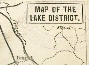
Railway map, Map of the Lake District, scale about 5.5
miles to 1 inch, published by Joseph Smith, 85 Fleet Street,
London, 1878.
|
||
|
(example Carlisle Library (169))
|
||
| map feature:- | plain cartouche & up is N & sea plain & coast form lines & rivers & lakes & county & settlements & railways | |
| inscription:- |
printed upper right
MAP OF THE / LAKE DISTRICT. |
|
| inscription:- |
printed bottom of page
Printed by Joseph Smith, of No.30, Loraine Road, Holloway, in the Parish of St. Mary, Islington, in the County of Middlesex, at the Printing Office of Messrs. Bradbury, Agnew, & Co., Lombard Street, / in the Precinct of Whitefriars, in the City of London, and published by him at No.85, Fleet Street, in the Parish of St. Bride, City of London, SATURDAY, May 4, 1878. |
|
| wxh, map:- | 94x105mm | |
| wxh, sheet:- | 22x14cm | |
| scale:- | 1 to 980000 ? (estimate) | |
| sources:- |
Carlisle Library Maps |
|
| items seen (illustrated items in bold):- | ||

|
Carlisle Library : Map 95 -- railway map -- Map of the Lake District | |
|
|
Carlisle Library : Map 103 -- railway map -- Map of the Lake District | |