 Plan of the City of Carlisle with the Position of the
Batteries Erected by the Duke of Cumberland
Plan of the City of Carlisle with the Position of the
Batteries Erected by the Duke of Cumberland

|

|
|
|
map type:- Smith 1746 map 2 |
|
|
|
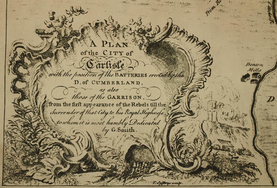
Town plan, A Plan of the City of Carlisle with the
Position of the Batteries Erected by the Duke of Cumberland,
Cumberland, scale about 12.5 inches to 1 mile, by G Smith,
engraved by T Jefferys, published by E Cave, St Johns Gate,
London, 1746
Edward Cave, under the pseudonum Sylvanus Urban, published the Gentleman's Magazine. |
||
|
(example Carlisle Library : ZBC912.1)
|
||
| map feature:- | streets | |
| inscription:- |
printed lower left, baroque cartouche
A PLAN / of the CITY of / Carlisle / with the position of the BATTERIES erected by the / D. of CUMBERLAND. / as also / those of the GARRISON. / from the first appearance of the Rebels till the / Surrender of that City to his Royal Highness / to whom it is most humbly dedicated / by G. Smith. |
|
| inscription:- |
printed lower left
T. Jefferys sculp. |
|
| inscription:- |
printed bottom
Publish'd according toAct of Parliament May ye 28 1746 Printed for E. Cave at S. Johns Gate |
|
| wxh, sheet:- | 50x38.5cm | |
| wxh, map:- | 447x320mm | |
| inscription:- |
printed with scale line
Yards |
|
| scale line:- | 600 yards = 108.8 mm | |
| scale:- | 1 to 5000 ? (1 to 5043 from scale line) | |
| sources:- |
Carlisle Library Maps |
|
| items seen (illustrated items in bold):- | ||

|
Carlisle Library : Map 338 -- street map -- Plan of the City of Carlisle with the Position of the Batteries Erected by the Duke of Cumberland | |