 Wordsworthshire

|

|
|
|
map type:- Robertson 1911 maps |
|
|
|
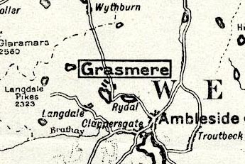
Map, of Wordsworthshire, scale about 7 miles to 1 inch,
by G W Bacon and Co, for Eric Robertson, published by Chatto
and Windus, London, 1911.
Folded and tipped into the book, Wordsworthshire, by Eric Robertson, Windermere, Westmorland, illustrated by Arthur Tucker, published by Chatto and Windus, London, 1911. Centred on Grasmere, with distance circles, the inner circle being the 'Heart of Wordsworthshire'. also:- Map, photo litho? The Dales, showing relief, by Eric Robertson? Map, engraving? The Meeting of the Ways, by Eric Robertson? derived from Yates's map of Lancashire, showing possible interpretations of William Wordsworth's Meeting of the Ways. Sketch map, diagram of Wordsworthshire, by Eric Robertson. |
||
|
(example JandMN (197_39))
|
||
| map feature:- | up is N & scale line & sea plain & coast line & rivers & lakes & relief & spot heights & county & settlements & roads & railways | |
| inscription:- |
printed bottom left, centre, right
COPYRIGHT / Published by Chatto & Windus / LONDON : G W BACON & C0., LTD. 127 STRAND. |
|
| wxh, sheet:- | 22x28.5cm | |
| wxh, map:- | 189x253mm | |
| inscription:- |
printed with scale line
SCALE OF MILES |
|
| scale line:- | 20 miles = 70.6 mm | |
| scale:- | 1 to 460000 ? (1 to 455905 from scale line) | |
| sources:- |
JandMN Collection |
|
| items seen (illustrated items in bold):- | ||

|
JandMN (197_23) -- map -- Meeting of the Ways | |
|
|
JandMN (197_36) -- sketch map -- Wordsworthshire | |
|
|
JandMN (197_38) -- map -- Dales, The | |
|
|
JandMN (197_39) -- map -- Wordsworthshire | |