 District of the Lakes

|

|
|
|
map type:- Red Guide 1892 map |
|
|
|
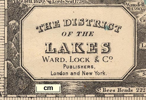
Map, The District of the Lakes, scale about 4 miles to 1
inch, published by Ward, Lock and Co, Warwick House,
Salisbury Square, London, etc, 1892.
Tipped in at the front of a Red Guide guide book, Guide to the English Lakes, 1892. The map is derived from Jonathan Otley's map of 1818. |
||

|
Otley 1818 | |
|
(map example JandMN (102_1))
|
||
| map feature:- | plain cartouche & north point & magnetic deviation & up is N & scale line & lat and long scales & sea tinted & coast shaded & rivers & lakes & relief & hill hachuring & woods & trees & settlements & roads & railways & canals | |
| inscription:- |
printed title cartouche, lower left
THE DISTRICT / OF THE / LAKES / WARD, LOCK & Co. / Publishers, / London and New York. |
|
| wxh, sheet:- | 28.5x37.5cm | |
| wxh, map:- | 260x348mm | |
| scale line:- | 10 miles = 62.9 mm | |
| scale:- | 1 to 260000 ? (1 to 255858 from scale line) | |
|
||
| sources:- |
JandMN Collection |
|
| items seen (illustrated items in bold):- | ||
|
|
JandMN (102_1) -- map -- District of the Lakes | |