 Winander Mere and its Vicinity

|

|
|
|
map type:- Prior 1874 map 2 |
|
|
|
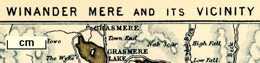
Map, Winander Mere and its Vicinity, scale about 1.5
miles to 1 inch, engraved by W Banks, Edinburgh, published
by John Garnett, Windermere, Westmorland, 1874.
Tipped in between pp.4-5 of A Sail on Winander Mere, by Herman Prior, |
||
|
(example private collection (133_2))
|
||
| map feature:- | up is N & scale line & rivers & lakes & relief & hill hachuring & county (including all the lake in Westmorland) & settlements & roads & railways | |
| inscription:- |
printed top
WINANDER MERE AND ITS VICINITY |
|
| inscription:- |
printed bottom
[W] Banks & Co. Edinburgh |
|
| wxh, sheet:- | 17.5x24cm | |
| wxh, map:- | 144x213mm | |
| inscription:- |
printed with scale line
Miles |
|
| scale line:- | 8 miles = 124.6 mm | |
| scale:- | 1 to 100000 ? (1 to 103329 from scale line) | |

|
||
| sources:- |
private collection |
|
| items seen (illustrated items in bold):- | ||

|
private collection (133_2) -- map -- Winander Mere and its Vicinity | |