 Pratt's Road Atlas of England and Wales

|

|
|
|
map type:- Pratt 1905 |
|
|
|
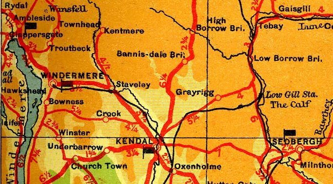
Road book, Pratt's Road Atlas of England and Wales, road
maps, scale 6 miles to 1 inch, by George Philip and Son, 32
Fleet Street, London, 1905, published by Anglo-American Oil
Co, 36-38 Queen Anne's Gate, Westminster, London, 1915.
The atlas has a table of lighting up times, general railway map of England and Wales, index map to road map plates, a table of symbols and diagram of heights showing layer colouring and the heights of places, 70 road map plates - Hampshire is mostly covered by plates 11 and 12, maps of routes out of London, street maps of towns, road gradient diagrams using the layer colours, explanations of a few road signs, table of speeds against time for 1 mile, and some advertisements. |
||
| map feature:- | up is N & lat and long grid & table of symbols & scale line & sea tinted & rivers & relief & layer colouring & settlements & roads & road distances & railways & golf courses | |
| inscription:- |
printed title page
PURVEYORS OF MOTOR SPIRIT / TO / H.M. THE KING. H.M. QUEEN ALEXANDRA. / PRATT'S / ROAD ATLAS OF / ENGLAND AND / WALES / FOR MOTORISTS / COPYRIGHTED 1905 / Published by / ANGLO-AMERICAN OIL CO., LTD., / 36-38 QUEEN ANNE'S GATE, / WESTMINSTER, LONDON, S.W. / Engraved and Printed by George Philip & Son, Ltd., / 32 Fleet Street, London E.C. / REVISED EDITION, 1915. red and black on white; coats of arms |
|
| wxh:- | 13x22cm | |
| scale line:- | 15 miles = 63.5 mm | |
| scale:- | 1 to 380000 ? (1 to 380160 from scale line) | |
| sources:- |
HMCMS Map Collection |
|
| items seen (illustrated items in bold):- | ||

|
Hampshire Museums : FA2001.138 -- road book -- Pratt's Road Atlas of England and Wales | |
|
|
JandMN (427) -- road book -- Pratt's Road Atlas of England and Wales | |