 Scotland

|

|
|
|
map type:- OS 1936 Ten Inch |
|
|
|
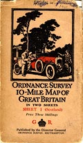
Map series, Ten Inch Map of Great Britain, with National
Yard Grid, scale 10 miles to 1 inch, published by the
Ordnance Survey, Southampton, Hampshire 1936-37.
The two sheets are both needed for Westmorland, Cumberland etc:- sheet 1 - Scotland sheet 2 - England (?) The index grid is at 50000 yard squares (cf 50Km squares). The map cover has an Ellis Martin design of a red Sunbeam motor car by a signpost, the driver and a passenger studying a map. |
||
|
||
| sources:- |
JandMN Collection Hellyer 1999 |
|
| items seen (illustrated items in bold):- | ||

|
JandMN (437_1) -- map -- Scotland | |