 OS 1900s Half Inch

|

|
|
|
map type:- OS 1900s Half Inch |
|
|
|
Map series, Half Inch series, with or without index grid,
hill shading series or layer colouring series, scale 2 miles
to 1 inch, published by the Ordnance Survey, from 1906.
The sheets for Westmorland, Cumberland etc are:- sheet 2 - Carlisle. sheet 3 - Newcastle on Tyne. sheet 5 - Lake District. sheet 6 - [unnamed, Darlington?] sheet 8 - Preston. |
||
|
||
| sources:- |
JandMN Collection Hellyer 1999 |
|
| items seen (illustrated items in bold):- | ||

|
JandMN (434_1) -- map -- Jedburgh and Alnwick -- Jedburgh, Berwick upon Tweed and Alnwick | |
|
|
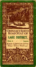
JandMN (434_5) -- map -- Lake District | |
|
|
JandMN (435_2) -- map -- Carlisle | |
|
|
JandMN (435_3) -- map -- Newcastle on Tyne -- Newcastle upon Tyne | |
|
|
JandMN (435_6) -- map | |
|
|
JandMN (435_8) -- map -- Preston -- Lancaster, Southport and Preston | |