 Sectional Cycling Map

|

|
|
|
map type:- Ogdens 1910 |
|
|
|
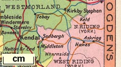
Map, cigarette card no.9 of 50 in the Sectional Cycling
Map series, showing the Westmorland area, scale about miles
to 1 inch, issued with Ogden's Cigarettes, by the Imperial
Tobacco Co, Nottingham, Nottinghamshire, about 1910.
The card shows parts of Lancashire, Westmorland, Cumberland, and Yorkshire. The set does not make a complete map of England or Britain, and does not have another card with the rest of The Lakes area. |
||
|
(map example JandMN (20))
|
||
| map feature:- | sea tinted & coast line & up is N & lakes & county & settlements & roads | |
| inscription:- |
printed obv
OGDEN'S / CIGARETTES |
|
| inscription:- |
printed rev
SECTIONAL CYCLING MAP. / 50 IN SERIES / ... No.9 ... / OGDEN'S CIGARETTES / ISSUED BY THE IMPERIAL TOBACCO CO. (OF GREAT BRITAIN & IRELAND), LTD. |
|
| sources:- |
JandMN Collection |
|
| items seen (illustrated items in bold):- | ||

|
JandMN (20) -- map -- Sectional Cycling Map | |