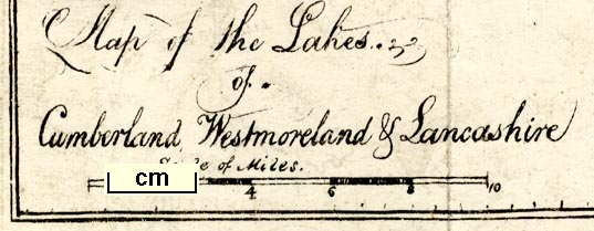
 Map of the Lakes of Cumberland, Westmoreland and
Lancashire
Map of the Lakes of Cumberland, Westmoreland and
Lancashire

|

|
|
|
map type:- Maude 1831 map |
|
|
|
Map of the Lakes of Cumberland, Westmoreland and
Lancashire, drawn by Gideon Michael Angelo Maude, published
by Thomas Inchbold, Leeds, Yorkshire, 1831.
Frontispiece, folded and tipped into A Tour into Westmoreland, and to the Moors, by Gideon Maude. The map is very much hand drawn, inaccurate, untidy, ... unreliable. |
||
|
(example Armitt Library : A1387.1)
|
||
| map feature:- | folded (3x2) & up is N & scale line & sea plain & coast shaded & rivers & lakes & relief & hill hachuring & table of heights & county & settlements & roads & canals | |
| inscription:- |
printed lower left
Map of the Lakes / of / Cumberland, Westmoreland & Lancashire |
|
| inscription:- |
printed bottom right, centre
drawn by G. M. A. Maude / Leeds published by Thomas Inchbold |
|
| wxh, sheet:- | 21x27.5cm | |
| wxh, map:- | 181x229mm | |
| inscription:- |
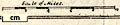
printed with scale line
Scale of Miles |
|
| scale line:- | 10 miles = 45.8 mm | |
| scale:- | 1 to 350000 ? (1 to 351385 from scale line assuming a statute mile) | |
|
||
| sources:- |
Armitt Library Bicknell 1990 |
|
| items seen (illustrated items in bold):- | ||

|
Armitt Library : A1387.1 -- map -- Map of the Lakes of Cumberland, Westmoreland and Lancashire | |