 General Sketch Map of the LNWR and its
Communications
General Sketch Map of the LNWR and its
Communications

|

|
|
|
map type:- LNWR 1887 |
|
|
|
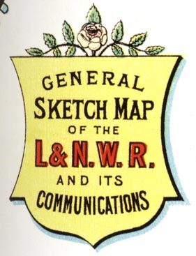
Railway map, General Sketch Map of the LNWR and its
Communications, by John Bartholomew, Edinburgh, published by
The London and NOrth Western Railway, London, 1887.
The map has panels left and right with pictures and location maps of the railway company's hotels. |
||
| map feature:- | title cartouche (shield) & up is N & scale line & sea tinted & coast tinted & settlements (on railway) & railways & shipping routes | |
| inscription:- |
printed title cartouch, upper left
GENERAL / SKETCH MAP / OF THE / L.&N.W.R. / AND ITS / COMMUNICATIONS |
|
| inscription:- |
printed shield cartouche, upper right
ROYAL MAIL / WEST COAST ROUTE / BETWEEN / ENGLAND / AND / SCOTLAND |
|
| inscription:- |
printed lower left
J. BARTHOLOMEW, EDINR. |
|
| references:- |
Spaven, David & Holland, Julian: 2011: Times Mapping the
Railways, The: Times Books (London):: ISBN 978 0 00 790286
6 |
|