 LMS Map of the Lake District

|

|
|
|
map type:- LMS 1930s |
|
|
|
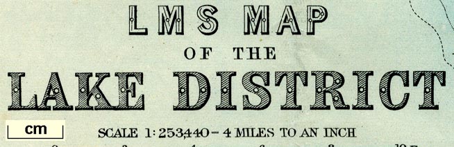
Railway map, LMS Map of the Lake District, scale about 4
miles to 1 inch, published for the London Midand and
Scottish Railway, LMS, by John Bartholomew and Son, The
Edinburgh Geographical Institute, Edinburgh, 1930s?
The railways shown are those included in the LMS after the grouping in 1923. |
||
|
(example JandMN (337))
|
||
| map feature:- | up is N & scale line & lat and long scales & lat and long grid & sea tinted & depth contours & coast tinted & foreshore sands & rivers & lakes & relief & hill hachuring & spot heights & woods & forests & parks & settlements & roads & railways | |
| inscription:- |
printed lower left
LMS MAP / OF THE / LAKE DISTRICT |
|
| inscription:- |
printed bottom left, right
THE EDINBURGH GEOGRAPHICAL INSTITUTE / COPYRIGHT - JOHN BARTHOLOMEW & SON, LTD. |
|
| wxh, sheet:- | 31.5x37cm | |
| wxh, map:- | 281x336mm | |
| inscription:- |
printed with scale line
SCALE 1 : 253,440 - 4 MILES TO AN INCH |
|
| scale line:- | 10 miles = 63.2 mm | |
| scale:- | 1 to 250000 ? (1 to 254653 from scale line) | |

|
||
| sources:- |
JandMN Collection |
|
| items seen (illustrated items in bold):- | ||

|
JandMN (337) -- railway map -- LMS Map of the Lake District | |