 Bathymetrical Survey of Grasmere Lake

|

|
|
|
map type:- Green 1902 |
|
|
|
Map, Bathymetrical Survey of Grasmere Lake, scale about
25 ins to 1 mile, by T A Green, Grasmere, Westmorland, 1902.
The map has a street plan of Grasmere, and four views of the lake from North, East, South and West. |
||
|
(example Armitt Library : 1959.195)
|
||
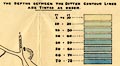
| map feature:- | north point & up is N & rivers & lakes & depth soundings & depth contours & table of depths & settlements & roads & town plan | |
| inscription:- |
printed upper left
BATHYMETRICAL SURVEY / OF / GRASMERE LAKE / BY / T. A. GREEN, GRASMERE. / ... / 1902. |
|
| wxh, sheet:- | 58.5x91.5cm | |
| wxh, map:- | 542x850mm | |
| scale:- | 1 to 2500 ? | |
|
||
| sources:- |
Armitt Library |
|
| items seen (illustrated items in bold):- | ||

|
Armitt Library : 1959.195 -- map -- Bathymetrical Survey of Grasmere Lake | |