 Geological Survey Ten Mile Map

|

|
|
|
map type:- Geological Survey 1948 Ten Inch |

|
|
|
Geological map, 2 sheets, The Geological Survey Ten Mile
Map, Geological Map of Scotland and the North of England,
and Geological Map of England and Wales, scale about 10
miles to 1 inch, by the Geological Survey on outline maps by
the Ordnance Survey, 1948.
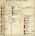
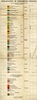
There are stratigraphical columns giving the colours, and letter codes, for the geological strata printed on each sheet. Beware: the colourings and codings are declared for Scotland and England north of 55Km N, and England south of 550Km N, an are different. This is awkward for the Lakes area. The whole map is printed on two sheets, Great Britain North and South. The Lakes area is divided, part on each sheet. The stratigraphical colouring does not change at the 550Km line, but notice that the letter codings are given in both systems. |
||
|
(example map JandMN (146))
|
||
| map feature:- | mounted (on linen) & folded (effective for use, but producing tears and grubbinesses) & card covers & scale line & lat and long scales & index grid (national grid) & sea plain & coast line & rivers & county & settlements & roads & geology | |
| inscription:- |
north sheet: printed cover
SHEET ONE / GEOLOGICAL SURVEY / 'TEN-MILE' MAP / Published 1948 / Price 15/- / PRINTED ON OUTLINE MAPS OF THE ORDNANCE SURVEY black on cream, olive green border; illustration of geologists at work near a coast; index map; royal coat of arms |
|
| inscription:- |
morth sheet: right centre
GEOLOGICAL MAP / OF / SCOTLAND / AND THE / NORTH OF ENGLAND / PREPARED BY THE GEOLOGICAL SURVEY / 1948 |
|
| wxh, sheet:- | 103.5x82cm | |
| wxh, folded:- | 13.5x21cm | |
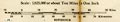
| scale line:- | 50+10 miles = 154.7 mm | |
| scale:- | 1 to 625000 ? (nominal) | |
|
||
|
||
|
||
| sources:- |
JandMN Collection |
|
| items seen (illustrated items in bold):- | ||

|
JandMN (146) -- geological map -- Geological Survey Ten Mile Map -- Geological Map of Scotland and the North of England -- Geological Map of England and Wales | |