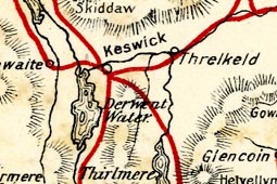
 Map of Author's Route

|

|
|
|
map type:- Bradley 1901 map |
|
|
|
Map of Author's Route, in The Lakes, Westmorland,
Cumberland and Lancashire, scale about 8.5 miles to 1 inch,
drawn for A G Bradley, published by Macmillan and Co,
London, 1901.
Tipped in at end of Highways and Byways in the Lake District. |
||
| map features:- | folded (4x1, to fold out and be read while reading the book) & up is N & scale line & sea plain & coast line & rivers & lakes & relief & hill hachuring & county & settlements & (roads are not shown except the author's route overprinted in red) | |
| inscription:- |
printed top right
Bradley's English Lakes |
|
| inscription:- |
printed list of plates, prelims
MAP OF AUTHOR'S ROUTE ... End of Volume. |
|
| inscription:- |
printed bottom left
R. & R. Clark, Ltd., Printers Edinburgh |
|
| wxh, sheet:- | 36x20cm | |
| wxh, map:- | 211x160mm | |
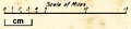
| inscription:- |
printed with scale line
Scale of Miles |
|
| scale line:- | 15 miles = 45.0 mm | |
| scale:- | 1 to 540000 ? (1 to 536448 from scale line) | |
|
||
| sources:- |
JandMN Collection |
|