 Bowen and Bowen 1767

|

|
|
|
map type:- Bowen and Bowen 1767 |
|
|
|
Map, Cumberland and Westmorland, scale about 9 miles to 1
inch, by Emanuel Bowen and Thomas Bowen, published by Thomas
Kitchin, 59 Holborn Hill, London, about 1767; published 1767
to 1793.
Published in 'Atlas Anglicanus, Or a Complete Sett of Mapps of the Counties of South Britain; Divided into their respective Hundreds, Wapentakes, Wards, Rapes, Lathes, &c. Exhibiting the Cities, Boroughs, market Towns, Parishes & Principal Villages; with the Number of Members returned to Parliament & the Market Days annexed to each Town; Describing also the Church Livings. The whole Illustrated with Historical Extracts, relative to Natural produce, Trade, Manufactures &c. both Entertaining and Instructive; With Various Improvements, not Inserted in any other Sett of Half Sheet Map extant. To which is added a Correct Map of the Roads of England, with the Distances agreeable to the Mile Stones and other exact Admensurations, between the Principal Towns. By the late Emanuel Bowen, Geographer to His Majesty George IId. and Thomas Bowen. Printed for T. Kitchin, No.59, Holborn Hill.' 1767. The atlas has historical notes; its size is 9 1/4 x 14 3/4 ins. The Westmorland and Cumberland plate may have a number, '6'. This is probably a pigeon hole or bin number from the publisher's warehouse, not a plate number. Published in another edition 'Atlas Anglicanus ... 1777. Printed for T. Kitchin, No.59, Holborn Hill. & Andrew Dury, Duke's Court, St. Martins Lane.' 1777. Published in 'Bowles's New Medium English Atlas; Or, Complete Set of Maps of the Counties of England and Wales: Divided Into Their Respective Hundreds, Wapentakes, Wards, Rapes, Lathes, &c. Exhibiting The Roads, Rivers, Cities; Borough, Market, and Seaport Towns; Principal Villages and Places of Note; with their Distances from London, and Members sent to Parliament; also Church-Livings, Seats of the nobility, and a Variety of Historical Extracts relative to Natural Produce, Trade, Manufactures and Commerce. Compiled and laid down from the latest and most approved Authorities. ... London, Printed for the Proprietor Carington Bowles, at his Map and Print Warehouse, No.69, in St. Paul's Church Yard, M DCC LXXXV.' ie 1785. Published in another edition 'Bowles's New Medium Atlas; ...' by Bowles and Carver, after 1793. |
||
|
(map example Dove Cottage : 2007.38.122)
|
||
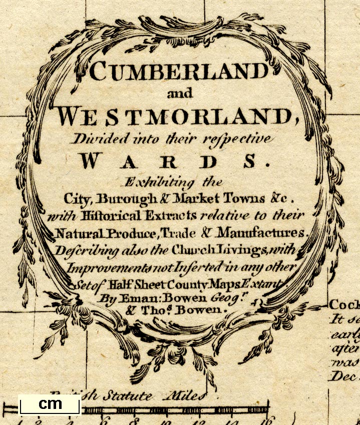
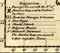
| map feature:- | foliage cartouche & table of symbols & descriptive text & compass rose & up is N & scale line & lat and long scales (rectangular projection, W from London) & lat and long grid & sea plain & coast form lines & rivers & lakes & relief & hillocks & forests & trees & parks & county & settlements & roads & road distances | |
| inscription:- |
printed title cartouche, upper left
CUMBERLAND / and / WESTMORLAND, / Divided into their respective / WARDS. / Exhibiting the / Ciry, Borough & Market Towns &c. / with Historical Extracts relative to their / Natural Produce, Trade & Manufactures. / Describing also the Church Livings, with / Improvements not Inserted in any other / Set of Half Sheet County Maps Extant. / By Eman : Bowen Geogr. / & Thos. Bowen. |
|
| inscription:- |
printed bottom
Printed for Tho. Kitchin at No.59 Holborn Hill London. |
|
| wxh, sheet:- | 26.5x39cm | |
| wxh, plate:- | 234x333mm | |
| wxh, map:- | 226x321mm | |
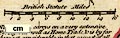
| scale line:- | 16 miles = 44.9 mm | |
| scale:- | 1 to 570000 ? (1 to 573486 from scale line wrongly assuming a statute mile) | |
| longitude, Kendal:- | 2d 50.8m W (approx) | |
|
||
|
||
| references:- |
Bowen, Emanuel & Bowen, Thomas: 1767: Atlas Anglicanus:
Complete Sett of Mapps of the Counties of South Britain:
Kitchin, Thomas (London) Bowen, Emanuel & Bowen, Thomas: 1777: Atlas Anglicanus: Complete Sett of Mapps of the Counties of South Britain: Kitchin, Thomas & Dury, Andrew (London) : 1785: Bowles's New Medium English Atlas & Complete Set of Maps of the Counties of England and Wales: Bowles, Carington (London) : 1793 (after): Bowles's New Medium English Atlas & Complete Set of Maps of the Counties of England and Wales: Bowles and Carver (London) |
|
| sources:- |
Chubb 1927 (CCXXXII) Hodson 1984 Wordsworth Trust Collection Carlisle Library Maps |
|
| items seen (illustrated items in bold):- | ||

|
Armitt Library : ALMC2008.14.120 -- map -- Cumberland and Westmorland | |
|
|
Carlisle Library : Map 7 -- map -- Cumberland and Westmorland | |
|
|
Dove Cottage : 2007.38.122 -- map -- Cumberland and Westmorland | |