 Black 1884 map

|

|
|
|
map type:- Black 1884 map |
|
|
|
Series of small maps printed in the text of Black's Guide
to The Lakes, 1884.
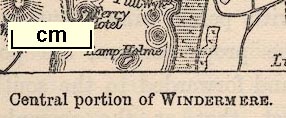
Published in 'BLACK'S GUIDE TO THE ENGLISH LAKES OF CUMBERLAND AND WESTMORLAND / SIXTEENTH EDITION EDINBURGH ADAM AND CHARLES BLACK 1884' Most of the small maps are not titled, and are all about 1 inch to 1 mile. They are rectangular, circular, and in one instance triangular:- Central portion of Windermere lake. Windermere Ferry. Hawkshead. Coniston and north part of Coniston Water. Upper reach of Windermere lake. Ambleside and Troutbeck area. Keswick and north part of Derwentwater. South part of Ullswater. Shap and Shap Abbey. |
||
| sources:- |
JandMN Collection Bicknell 1990 |
|
| items seen (illustrated items in bold):- | ||

|
JandMN (59_2) -- map -- Central Portion of Windermere | |
|
|
JandMN (59_3) -- map -- Windermere Ferry | |
|
|
JandMN (59_4) -- map | |
|
|
JandMN (59_5) -- map | |
|
|
JandMN (59_6) -- map -- Windermere, Upper Reach | |
|
|
JandMN (59_7) -- map | |
|
|
JandMN (59_8) -- map -- Keswick and Derwentwater | |
|
|
JandMN (59_9) -- map -- Chart of the Lake Ullswater | |
|
|
JandMN (59_10) -- map | |