 Lake District of Cumberland, Westmorland and
Lancashire
Lake District of Cumberland, Westmorland and
Lancashire

|

|
|
|
map type:- Black 1850s map |
|
|
|
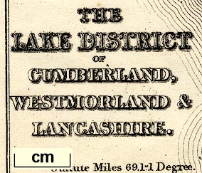
Map, Lake District of Cumberland, Westmorland and
Lancashire, scale about 5 miles to 1 inch, engraved by S
Hall, Bury Street, Bloomsbury, London, published by A and C
Black, Edinburgh, 1850s.
Perhaps used in an edition of Black's Guide to the Lakes? The railways shown are - Lancaster and Carlisle Railway open 1846, Kendal and Windermere Railway open 1846, Cockermouth and Workington Railway open 1847, Whitehaven and Furness Junction Railway open 1850-55, Furness Railway open 1840s. |
||
|
(JandMN (163))
|
||
| map feature:- | up is N & scale line & sea plain & coast form lines & rivers & lakes & relief & hill hachuring & forests & parks & county & settlements & roads & canals & railways | |
| inscription:- |
printed lower left
THE / LAKE DISTRICT / OF / CUMBERLAND, / WESTMORLAND & / LANCASHIRE. |
|
| inscription:- |
printed bottom
left, right, centre |
|
| wxh, sheet:- | 23x18cm | |
| wxh, map:- | 188x147mm | |
| inscription:- |
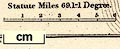
printed above scale line
Statute Miles 69.1=1 Degree. |
|
| scale line:- | 6 miles = 29.0 mm | |
| scale:- | 1 to 330000 ? (1 to 332968 from scale line) | |
|
||
| sources:- |
JandMN Collection |
|
| items seen (illustrated items in bold):- | ||

|
JandMN (163) -- map -- Lake District of Cumberland, Westmorland and Lancashire | |