 Bartholomew's Half Inch Series

|

|
|
|
map type:- Bartholomew 1940s |
|
|
|
Map series, Bartholomew's Half Inch Series, scale 2 miles
to 1 inch, published by John Bartholomew and Son, The
Geographical Institute, Duncan Street, Edinburgh, Scotland,
about 1940s-50s.
The sheets that are needed for Westmorland, Cumberland and parts of Lancashire and Yorkshire, now Cumbria, are:- sheet 38 - The Solway sheet 39 - Tyneside sheet 34 - English Lakes sheet 31 - North Lancashire Each sheet has an index map of the series on the back cover; beware - the sheets on the index map are not always the same as what you get. Other sheets overlap those listed above. |
||
|
(map example )
|
||
| map feature:- | folded & card covers & table of symbols & north point & magnetic deviation & scale line & lat and long scales & sea tinted & coast line & rivers & relief & contours & layer colouring & table of heights & woods & forests & trees & parks & county & settlements & roads & railways & canals | |
| inscription:- |
printed cover
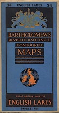
34 ENGLISH LAKES 34 / BY APPOINTMENT TO THE LATE KING GEORGE V. / BARTHOLOMEW'S / REVISED 'HALF-INCH' / CONTOURED / MAPS / PUBLISHED AT THE EDINBURGH / GEOGRAPHICAL INSTITUTE BY / JOHN BARTHOLOMEW & SON LTD / GREAT BRITAIN, SHEET 34 / ENGLISH LAKES / PAPER 3/- NET black and orange on blue; royal coat of arms; map of Great Britain |
|
| scale line:- | 10+1 miles = 137.5 mm | |
| scale:- | 1 to 126720 ? (nominal) | |
| wxh, folded:- | 11x19.5cm | |
| wxh, sheet:- | 84x56.5cm | |
| wxh, map:- | 80.5x52.5cm | |
|
||
| sources:- |
|
|
| sources:- |
JandMN Collection |
|