|

|
|
|
|
map type:-
Bartholomew
1930s
|
|
|
|
Map series, Bartholomew's Half Inch to Mile Map of
England and Wales, scale 2 miles to 1 inch, published by
John Bartholomew and Son, The Geographical Institue, Duncan
Street, Edinburgh, Scotland, about 1930s.
The sheets that concern Westmorland, Cumberland and parts of
Lancashire and Yorkshire, now Cumbria, are perhaps:-
sheet Scotland series 2 - Dumfries ?
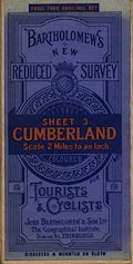
sheet 3 - Cumberland
sheet 2 - Newcastle ?
sheet 4 - Durham ?
sheet 5 - Barrow
sheet 6 - York ?
|
|
|
(map example )
|
|
|
map feature:-
|
sectioned for folding & mounted & card covers &
table of symbols & compass rose & magnetic deviation
& scale line & lat and long scales & sea tinted
& coast line & rivers & relief & contours
& layer colouring & table of heights & woods
& forests & trees & parks & county &
settlements & roads & railways & canals
|
|
|
inscription:-
|
printed cover
PRICE FOUR SHILLINGS NET / BARTHOLOMEW'S / NEW / REDUCED
SURVEY / SHEET 3 / CUMBERLAND / Scale 2 Miles to an Inch. /
COLOURED / FOR / TOURISTS / & CYCLISTS / JOHN BARTHOLOMEW &
SON, LTD. / The Geographical Institute, / DUNCAN ST.,
EDINBURGH / DISSECTED & MOUNTED ON CLOTH
red and black on blue; globe and crown
|
|
|
inscription:-
|
trade mark: printed globe, crown and garter
JOHN BARHOLOMEW; SON. LTD.
|
|
|
scale line:-
|
55 miles = 71 cm (approx)
|
|
|
scale:-
|
1 to 126720 ? (nominal)
|
|
|
wxh, folded:-
|
9.5x19.5cm
|
|
|
wxh, sheet:-
|
76.5x55.5cm
|
|
|
wxh, sheet:-
|
70x50cm
|
|
|
|

|
|
|
sources:-
|
JandMN Collection
|


 Bartholomew's Half Inch to Mile Map of England and
Wales